File:Ok-33 path.svg
Jump to navigation
Jump to search

Size of this PNG preview of this SVG file: 800 × 386 pixels. Other resolutions: 320 × 154 pixels | 640 × 308 pixels | 1,024 × 494 pixels | 1,280 × 617 pixels | 2,560 × 1,234 pixels | 973 × 469 pixels.
Original file (SVG file, nominally 973 × 469 pixels, file size: 51 KB)
Captions
Captions
Add a one-line explanation of what this file represents
Summary[edit]
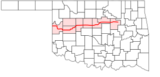
| Description | A map showing the path of State Highway 33 in Oklahoma. |
| Date | |
| Source | Created by me in Inkscape 0.43 based on data collected from Google Earth by User:KJBurns. |
| Author | Scott Nazelrod |
| Permission (Reusing this file) |
Public domain, credit appreciated but not required |
Licensing[edit]
| I, the copyright holder of this work, release this work into the public domain. This applies worldwide. In some countries this may not be legally possible; if so: I grant anyone the right to use this work for any purpose, without any conditions, unless such conditions are required by law. |
File history
Click on a date/time to view the file as it appeared at that time.
| Date/Time | Thumbnail | Dimensions | User | Comment | |
|---|---|---|---|---|---|
| current | 03:29, 4 June 2006 | | 973 × 469 (51 KB) | Scott5114 (talk | contribs) | {{Information |Description=A map showing the path of w:State Highway 33 (Oklahoma) in Oklahoma. |Source=Created by me in Inkscape 0.43 based on data collected from Google Earth by User:KJBurns. |Date=2 June 2006 |Author=[[User:Scott5 |
You cannot overwrite this file.
File usage on Commons
There are no pages that use this file.