File:Operation Dragoon - map.jpg
Fitxer original (1.265 × 965 píxels, mida del fitxer: 1,94 Mo, tipus MIME: image/jpeg)
Llegendes
Llegendes

|
Aquesta imatge (de tipus military map) s'hauria de tornar a crear utilitzant gràfics vectorials com ara un fitxer SVG. Això té diversos avantatges; en trobareu més informació a Commons:Media for cleanup. Si ja disposeu d'una versió d'aquesta imatge en format SVG, us preguem que la pengeu; després, reemplaceu aquesta plantilla amb la plantilla {{Vector version available|nom nou de la imatge.svg}} en aquesta imatge.
|


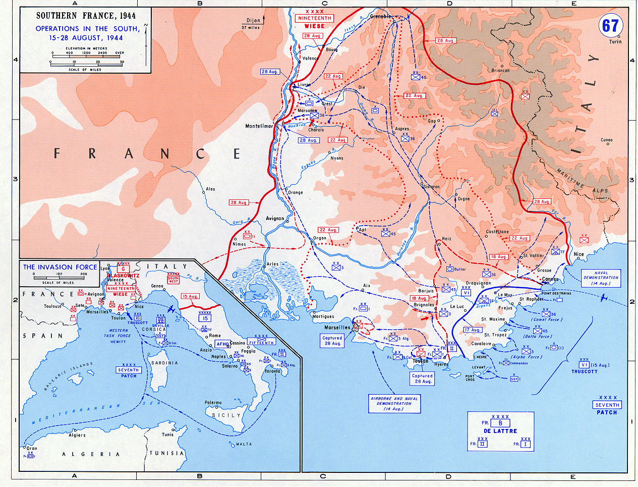
- Description: Operation Dragoon - Aug. 1944
- Source: www.dean.usma.edu
- Background information:
In 1938 the predecessors of what is today The Department of History at the United States Military Academy began developing a series of campaign atlases to aid in teaching cadets a course entitled, "History of the Military Art." Since then, the Department has produced over six atlases and more than one thousand maps, encompassing not only America’s wars but global conflicts as well.
In keeping abreast with today's technology, the Department of History is providing these maps on the internet as part of the department's outreach program. The maps were created by the United States Military Academy’s Department of History and are the digital versions from the atlases printed by the United States Defense Printing Agency. We gratefully acknowledge the accomplishments of the department's former cartographer, Mr. Edward J. Krasnoborski, along with the works of our present cartographer, Mr. Frank Martini.
Please be aware that these maps are large in file size and may require substantial download times.
Notes
[modifica]
- The indication "Dijon 37 miles" in the top middle of the map is most likely an error and should read "Lyon 37 miles".
Aquesta imatge és obra d'un soldat o empleat de l'exèrcit dels EUA feta durant la prestació oficial de servei. Com a obra del govern federal dels EUA, la imatge és en el domini públic.
|
 |
Historial del fitxer
Cliqueu una data/hora per veure el fitxer tal com era aleshores.
| Data/hora | Miniatura | Dimensions | Usuari/a | Comentari | |
|---|---|---|---|---|---|
| actual | 16:50, 23 maig 2018 | | 1.265 × 965 (1,94 Mo) | Hohum (discussió | contribucions) | Colour adjust |
| 17:53, 14 set 2005 |  | 1.265 × 965 (1,93 Mo) | W.wolny (discussió | contribucions) |
No podeu sobreescriure aquest fitxer.
Ús del fitxer
Les 3 pàgines següents utilitzen aquest fitxer:
Ús global del fitxer
Utilització d'aquest fitxer en altres wikis:
- Utilització a azb.wikipedia.org
- Utilització a bg.wikipedia.org
- Utilització a ca.wikipedia.org
- Utilització a cs.wikipedia.org
- Utilització a da.wikipedia.org
- Utilització a de.wikipedia.org
- Utilització a el.wikipedia.org
- Utilització a en.wikipedia.org
- Utilització a eo.wikipedia.org
- Utilització a es.wikipedia.org
- Utilització a fa.wikipedia.org
- Utilització a fi.wikipedia.org
- Utilització a fr.wikipedia.org
- Utilització a he.wikipedia.org
- Utilització a hu.wikipedia.org
- Utilització a id.wikipedia.org
- Utilització a it.wikipedia.org
- Utilització a ja.wikipedia.org
- Utilització a ko.wikipedia.org
- Utilització a nl.wikipedia.org
- Utilització a no.wikipedia.org
- Utilització a pl.wikipedia.org
- Utilització a ro.wikipedia.org
- Utilització a ru.wikipedia.org
- Utilització a sh.wikipedia.org
- Utilització a sk.wikipedia.org
- Utilització a sl.wikipedia.org
- Utilització a sv.wikipedia.org
- Utilització a ta.wikipedia.org
- Utilització a th.wikipedia.org
- Utilització a tr.wikipedia.org
- Utilització a uk.wikipedia.org
- Utilització a www.wikidata.org
- Utilització a zh.wikipedia.org