File:Ordnance Survey Drawings - Andover (OSD 77).jpg
Jump to navigation
Jump to search

Size of this preview: 800 × 565 pixels. Other resolutions: 320 × 226 pixels | 640 × 452 pixels | 1,024 × 723 pixels | 1,280 × 904 pixels | 2,560 × 1,808 pixels | 4,000 × 2,825 pixels.
Original file (4,000 × 2,825 pixels, file size: 4.41 MB, MIME type: image/jpeg)
Captions
Captions
Add a one-line explanation of what this file represents
| Andover (OSD 77)
|
|||||
|---|---|---|---|---|---|
| Title |
Ordnance Survey Drawings: Andover (OSD 77) |
.jpg) | |||
| Object type |
manuscript map |
||||
| Description |
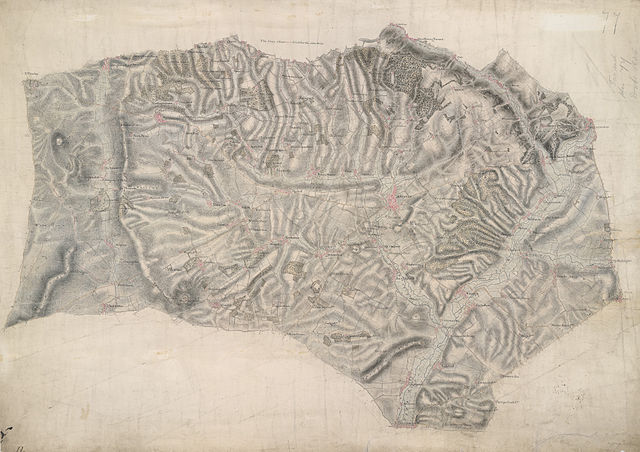
 Centre of map shown on a map of England
English: This drawing delineates the county border of Hampshire and Wiltshire. The boundary is marked as a red pecked line and follows the path of main roads and field boundaries. At Fullerton, the River Test branches into its tributaries. The draughtsman names each river and canal and depicts their various intersections. Main communication routes are tinted yellow, with the road near Doles Wood at the top of the plan marked "TG", meaning toll gate. Attention paid to communication routes is evidence of the military focus of the survey. Several archaeological sites are marked in this area, with the neighbouring hillforts of Sidbury and Quarley indicated by concentric rings towards the top left of the map. Varying shades of green are used to distinguish forests and meadows..
This image has been georeferenced.
|
||||
| Language |
English |
||||
| Date | 1808 | ||||
| Medium | Pen and ink on paper | ||||
| Dimensions | height: 290 mm (11.41 in); width: 400 mm (15.74 in) | ||||
| Collection | |||||
| Accession number |
Maps OSD 77 |
||||
| Credit line | British Library | ||||
| Notes |
Scale 2 inches : 1 mile ( 1: 31680). Please note that the British Library provides these digital files "as-is"; materials will not be rephotographed under this programme. If resupply of files is required, the requestor will be required to purchase them at the standard rate. |
||||
| References |
http://www.bl.uk/onlinegallery/onlineex/ordsurvdraw/a/002osd000000007u00053000.html (English) |
||||
| Source/Photographer |
|
||||
| Permission (Reusing this file) |
|
||||


_(St_Edwards_Crown).svg)
.jpg¶ms=51.202714_N_-1.52846_E_)
.jpg¶ms=51.088949_N_-1.761422_E_)
.jpg¶ms=51.316479_N_-1.295497_E_)
.jpg¶ms=51.316479_N_-1.71408_E_)
.jpg¶ms=51.128635_N_-1.761422_E_)
.jpg¶ms=51.088949_N_-1.342839_E_)
.jpg¶ms=51.276793_N_-1.295497_E_)
File history
Click on a date/time to view the file as it appeared at that time.
| Date/Time | Thumbnail | Dimensions | User | Comment | |
|---|---|---|---|---|---|
| current | 22:21, 26 September 2013 | | 4,000 × 2,825 (4.41 MB) | LibraryBot (talk | contribs) | {{subst:User:Andrew Gray/OSD|ID= 002OSD000000007U00053000 |OSD_NUM= OSD 77 |MEDIUM= Pen and ink on paper |TITLE= Andover |CREATOR= |YEAR= 1808 |DESCRIPTION= This drawing delineates the county border of Hampshire and Wiltshire. The boundary is marked a... |
You cannot overwrite this file.
File usage on Commons
The following page uses this file:
File usage on other wikis
The following other wikis use this file:
- Usage on www.wikidata.org
.jpg&oldid=912379963)