File:Ordnance Survey Drawings - Midhurst (OSD 84).jpg
Jump to navigation
Jump to search
Size of this preview: 790 × 600 pixels. Other resolutions: 316 × 240 pixels | 632 × 480 pixels | 1,012 × 768 pixels | 1,280 × 972 pixels | 2,560 × 1,944 pixels | 4,000 × 3,037 pixels.
Original file (4,000 × 3,037 pixels, file size: 4.87 MB, MIME type: image/jpeg)
Captions
Captions
Add a one-line explanation of what this file represents
| Midhurst 8 (OSD 84)
|
|||||
|---|---|---|---|---|---|
| Artist |
Budgen, Charles - Draughtsman |
.jpg) | |||
| Title |
Ordnance Survey Drawings: Midhurst (OSD 84) |
||||
| Object type |
manuscript map |
||||
| Description |
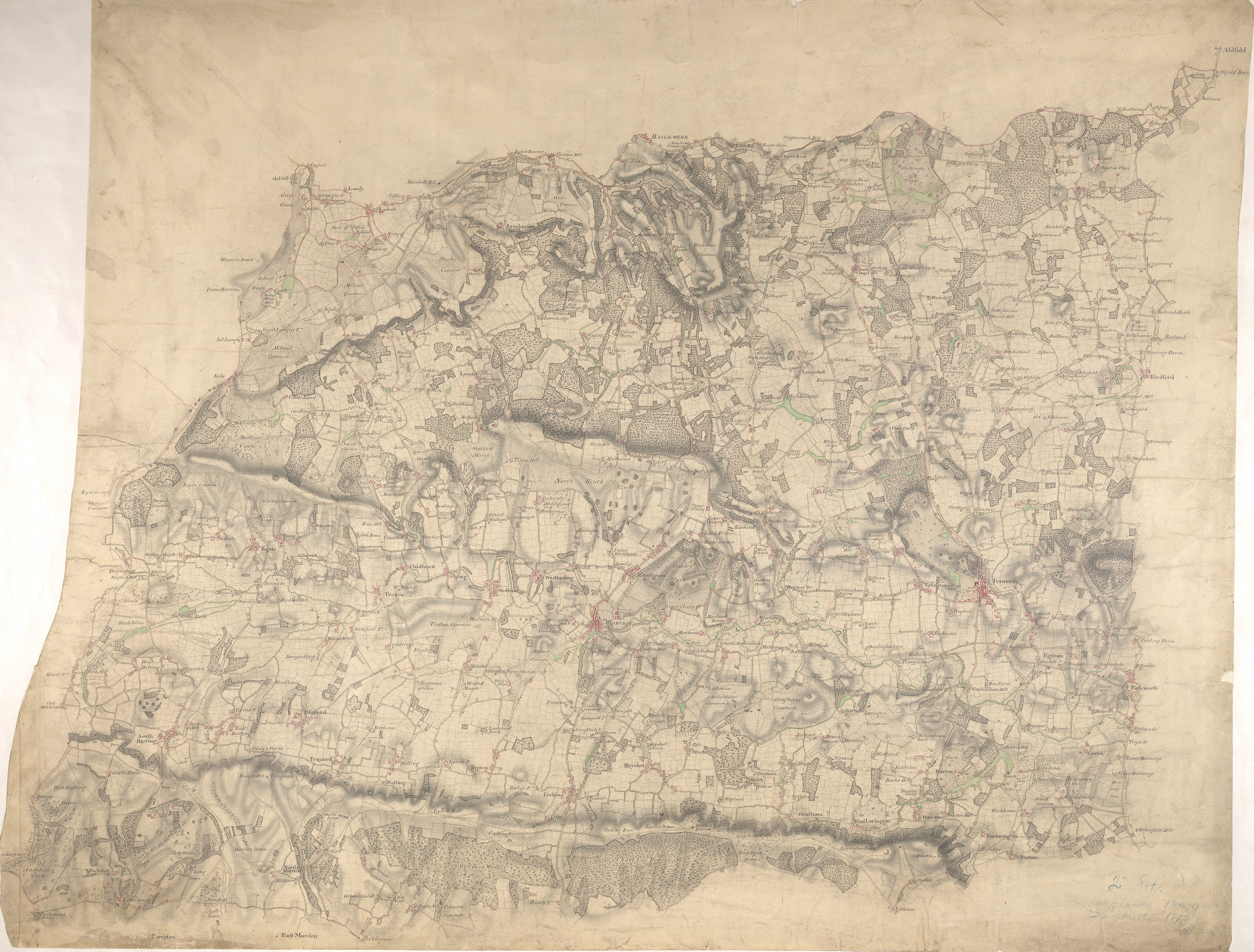
 Centre of map shown on a map of England
English: The counties of Hampshire, Surrey and Sussex are separated by a red dashed boundary line in this map of the South Downs and the River Rother Valley. Archaeological details are recorded at Duncton Beacon and Irons Barrow even though such documentation did not become obligatory until 1816. Trees and woodland dominate this undulating landscape. Individual trees with a small vertical stem and a shadow at the base are painstakingly drawn, as well as more general, stippled representations of tree tops en masse. The detailed representation of woodland highlights the military emphasis of the survey: trees could hinder or hide the movement of a regiment. The paper bears the watermark '1903.'.
This image has been georeferenced.
|
||||
| Language |
English |
||||
| Date | 1808 | ||||
| Medium | Pen and ink on paper | ||||
| Dimensions | height: 300 mm (11.81 in); width: 370 mm (14.56 in) | ||||
| Collection | |||||
| Accession number |
Maps OSD 84 |
||||
| Credit line | British Library | ||||
| Notes |
Scale 2 inches : 1 mile (1:31680). Please note that the British Library provides these digital files "as-is"; materials will not be rephotographed under this programme. If resupply of files is required, the requestor will be required to purchase them at the standard rate. |
||||
| References |
http://www.bl.uk/onlinegallery/onlineex/ordsurvdraw/m/002osd000000008u00061000.html (English) |
||||
| Source/Photographer |
|
||||
| Permission (Reusing this file) |
|
||||


_(St_Edwards_Crown).svg)
.jpg¶ms=51.017506_N_-0.724922_E_)
.jpg¶ms=50.906686_N_-0.944866_E_)
.jpg¶ms=51.128326_N_-0.504978_E_)
.jpg¶ms=51.128326_N_-0.919948_E_)
.jpg¶ms=50.924826_N_-0.944866_E_)
.jpg¶ms=50.906686_N_-0.529896_E_)
.jpg¶ms=51.110187_N_-0.504978_E_)
File history
Click on a date/time to view the file as it appeared at that time.
| Date/Time | Thumbnail | Dimensions | User | Comment | |
|---|---|---|---|---|---|
| current | 22:34, 26 September 2013 | | 4,000 × 3,037 (4.87 MB) | LibraryBot (talk | contribs) | {{subst:User:Andrew Gray/OSD|ID= 002OSD000000008U00061000 |OSD_NUM= OSD 84 |MEDIUM= Pen and ink on paper |TITLE= Midhurst |CREATOR= Budgen, Charles - Draughtsman |YEAR= 1808 |DESCRIPTION= The counties of Hampshire, Surrey and Sussex are separated by a... |
You cannot overwrite this file.
File usage on Commons
The following page uses this file:
File usage on other wikis
The following other wikis use this file:
- Usage on www.wikidata.org
.jpg&oldid=713429526)