File:Ordnance Survey Drawings - Welshpool (OSD 199).jpg
(Redirected from File:Ordnance Survey Drawings - Welshpool, Powys (OSD 199).jpg)

Size of this preview: 575 × 599 pixels. Other resolutions: 230 × 240 pixels | 461 × 480 pixels | 737 × 768 pixels | 983 × 1,024 pixels | 1,966 × 2,048 pixels | 4,050 × 4,219 pixels.
Original file (4,050 × 4,219 pixels, file size: 3.76 MB, MIME type: image/jpeg)
Captions
Captions
Add a one-line explanation of what this file represents
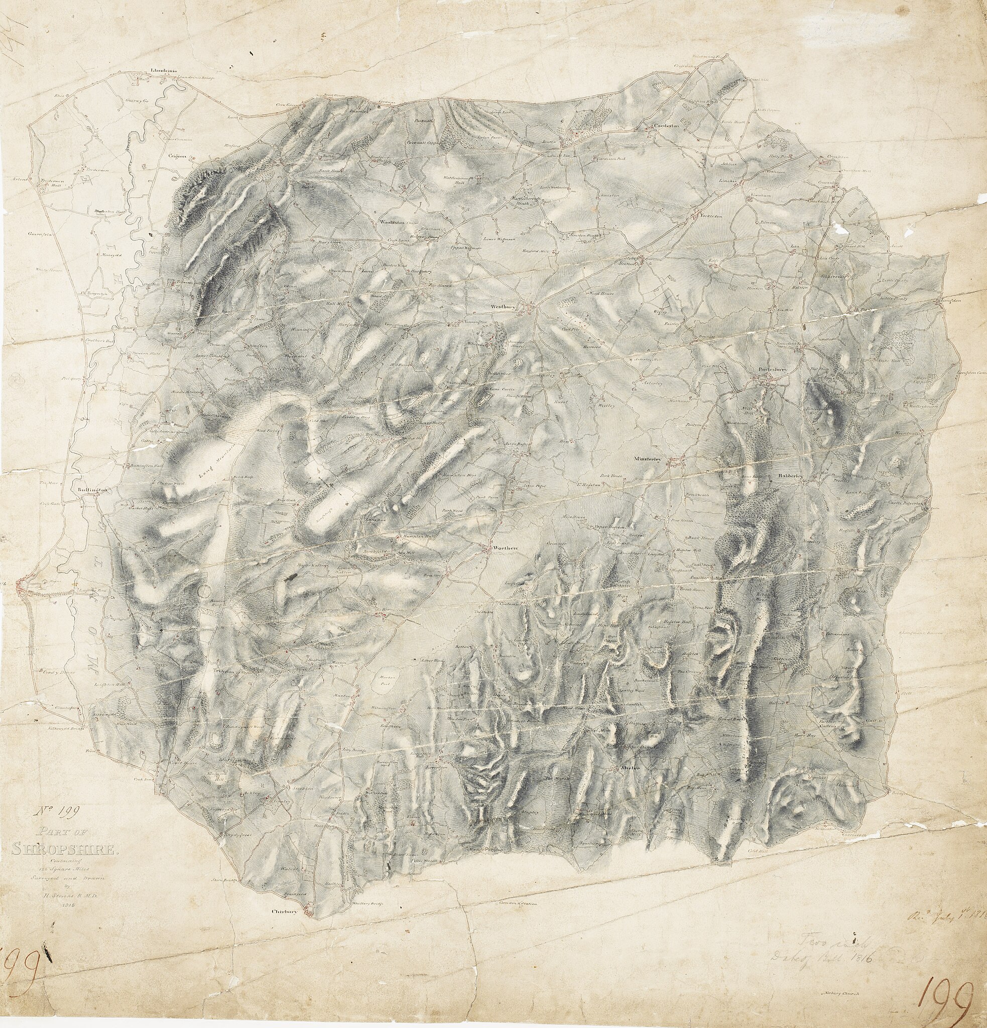
| Part of Shropshire containing 126 square miles. Surveyed and Drawn by H. Stevens R. M. D. 1816'' (OSD 199)
|
|||||
|---|---|---|---|---|---|
| Artist |
Stevens, Henry - Draughtsman |
.jpg) | |||
| Title |
Ordnance Survey Drawings: Welshpool, Powys (OSD 199) |
||||
| Object type |
manuscript map |
||||
| Description |
 Centre of map shown on a map of England
English: .This is the first map to conform fully to the 1816 Ordnance Survey Circular, which stated that every plan was to,have an area title, survey and drawing date,,and a note of,its author's,name and rank.,The,map shows,a section of Offa's Dyke, the great earth bank running 176 miles along or near the English border from the North Wales coast south to Chepstow., Offa's Dyke is eight miles longer than Hadrian's Wall but, because it was not a stone construction, was never garrisoned., Its purpose was to mark rathen than defend the frontier..
This image has been georeferenced.
|
||||
| Language |
English |
||||
| Date | 1816 | ||||
| Medium | Pen and ink on paper | ||||
| Dimensions | 310 × 310 mm (12.20 × 12.20 in) | ||||
| Collection | |||||
| Accession number |
Maps OSD 199 |
||||
| Credit line | British Library | ||||
| Notes |
Scale 2 inches : 1 mile (1:31680). Please note that the British Library provides these digital files "as-is"; materials will not be rephotographed under this programme. If resupply of files is required, the requestor will be required to purchase them at the standard rate. |
||||
| References |
http://www.bl.uk/onlinegallery/onlineex/ordsurvdraw/p/002osd000000003u00157000.html (English) |
||||
| Source/Photographer |
|
||||
| Permission (Reusing this file) |
|
||||


_(St_Edwards_Crown).svg)
.jpg&redirect=no)
.jpg¶ms=52.641691_N_-2.988776_E_)
.jpg¶ms=52.510608_N_-3.199713_E_)
.jpg¶ms=52.772773_N_-2.77784_E_)
.jpg¶ms=52.772773_N_-3.087045_E_)
.jpg¶ms=52.577306_N_-3.199713_E_)
.jpg¶ms=52.510608_N_-2.890508_E_)
.jpg¶ms=52.706075_N_-2.77784_E_)
File history
Click on a date/time to view the file as it appeared at that time.
| Date/Time | Thumbnail | Dimensions | User | Comment | |
|---|---|---|---|---|---|
| current | 09:10, 26 September 2013 | | 4,050 × 4,219 (3.76 MB) | LibraryBot (talk | contribs) | {{subst:User:Andrew Gray/OSD|ID= 002OSD000000003U00157000 |OSD_NUM= OSD 199 |MEDIUM= Pen and ink on paper |TITLE= Welshpool, Powys |CREATOR= Stevens, Henry - Draughtsman |YEAR= 1816 |DESCRIPTION= .This is the first map to conform fully to the 1816 Ordn... |
You cannot overwrite this file.
File usage on Commons
The following 2 pages use this file:
File usage on other wikis
The following other wikis use this file:
- Usage on www.wikidata.org
.jpg&oldid=906244210)