File:Ottawa, Illinois (7981644021).jpg

Original file (4,000 × 3,000 pixels, file size: 2.1 MB, MIME type: image/jpeg)
Captions
Captions
Summary[edit]
.jpg&action=edit§ion=1)
| Description |
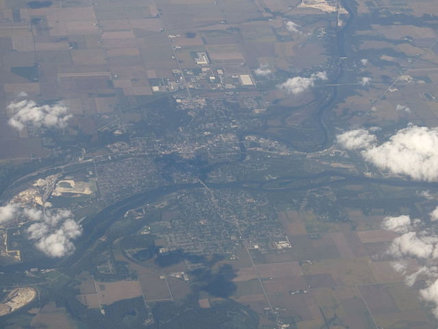
Ottawa is a city located at the confluence of the navigable Illinois River and Fox River in LaSalle County, Illinois, USA. The Illinois river is a conduit for river barges and connects Lake Michigan at Chicago, to the Mississippi river, and North America's 25,000 mile river system. As of the 2010 census, the city population was 18,786. It is the county seat of LaSalle County and it is part of the Ottawa-Streator Micropolitan Statistical Area, which was the 259th-most populous area in the United States in 2007. Ottawa was the site of the first of the Lincoln-Douglas debates of 1858. During the Ottawa debate Stephen A. Douglas, leader of the Democratic Party, openly accused Abraham Lincoln of forming a secret bipartisan group of Congressmen to bring about the abolition of slavery. The John Hossack House was a "station" on the Underground Railroad; Ottawa being a major stop, because of its rail, road and river transportation. Because of numerous silica sand deposits (Ottawa sand was on board the ill-fated Columbia space shuttle for experimental purposes) Ottawa has been a major sand and glass center for more than 100 years. Transportation of the sand is facilitated by the navigable Illinois river. One of its largest employers is Pilkington Glass works, a successor to LOF (Libbey Owens Ford). Formerly concentrated in automotive glass, the plant now manufactures specialty glass and underwent a $50 million renovation in 2006. Ottawa sand continues to be extracted from several quarries in the area, and is recognized in glass-making and abrasives for its uniform granularity and characteristics. en.wikipedia.org/wiki/Ottawa%2C_Illinois en.wikipedia.org/wiki/Wikipedia:Text_of_Creative_Commons_... |
| Date | |
| Source | Ottawa, Illinois |
| Author | Ken Lund from Reno, Nevada, USA |
| Camera location | | View this and other nearby images on: OpenStreetMap |
|---|
.jpg¶ms=041.342213_N_-088.842723_E_globe:Earth_type:camera_source:Flickr_&language=en)
Licensing[edit]
.jpg&action=edit§ion=2)
- You are free:
- to share – to copy, distribute and transmit the work
- to remix – to adapt the work
- Under the following conditions:
- attribution – You must give appropriate credit, provide a link to the license, and indicate if changes were made. You may do so in any reasonable manner, but not in any way that suggests the licensor endorses you or your use.
- share alike – If you remix, transform, or build upon the material, you must distribute your contributions under the same or compatible license as the original.
| This image was originally posted to Flickr by Ken Lund at https://flickr.com/photos/75683070@N00/7981644021. It was reviewed on 3 December 2015 by FlickreviewR and was confirmed to be licensed under the terms of the cc-by-sa-2.0. |
File history
Click on a date/time to view the file as it appeared at that time.
| Date/Time | Thumbnail | Dimensions | User | Comment | |
|---|---|---|---|---|---|
| current | 22:38, 3 December 2015 | | 4,000 × 3,000 (2.1 MB) | INeverCry (talk | contribs) | Transferred from Flickr via Flickr2Commons |
You cannot overwrite this file.
File usage on Commons
There are no pages that use this file.
.jpg&oldid=498082044)