File:Outer Hebrides UK relief location map.jpg
跳至導覽
跳至搜尋

預覽大小:456 × 600 像素。 其他解析度:182 × 240 像素 | 365 × 480 像素 | 584 × 768 像素 | 778 × 1,024 像素 | 2,001 × 2,632 像素。
原始檔案 (2,001 × 2,632 像素,檔案大小:481 KB,MIME 類型:image/jpeg)
說明
說明
添加單行說明來描述出檔案所代表的內容
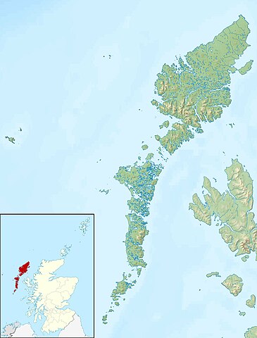
Relief map of the Outer Hebrides
| 描述 |
Relief map of the Outer Hebrides (excluding Sula Sgeir), UK. Equirectangular map projection on WGS 84 datum, with N/S stretched 180% Geographic limits:
|
| 日期 | |
| 來源 |
|
| 作者 | Nilfanion, created using Ordnance Survey data |
| 授權許可 (重用此檔案) |
此檔案採用創用CC 姓名標示-相同方式分享 3.0 未在地化版本授權條款。 姓名標示: Contains Ordnance Survey data © Crown copyright and database right
|
| 其他版本 | File:Outer Hebrides UK blank map.svg - Blank map |
檔案歷史
點選日期/時間以檢視該時間的檔案版本。
| 日期/時間 | 縮圖 | 尺寸 | 使用者 | 備註 | |
|---|---|---|---|---|---|
| 目前 | 2011年11月30日 (三) 12:26 | | 2,001 × 2,632(481 KB) | Nilfanion(留言 | 貢獻) | {{Information |Description=Relief map of the Outer Hebrides (excluding Sula Sgeir), UK. Equirectangular map projection on WGS 84 datum, with N/S stretched 180% Geographic limits: *West: 8.70W *East: 6.10W *North: 58 |
無法覆蓋此檔案。
檔案用途
下列2個頁面有用到此檔案:
全域檔案使用狀況
以下其他 wiki 使用了這個檔案:
- ar.wikipedia.org 的使用狀況
- bg.wikipedia.org 的使用狀況
- ceb.wikipedia.org 的使用狀況
- da.wikipedia.org 的使用狀況
- de.wikipedia.org 的使用狀況
- Soay (St. Kilda)
- Hirta
- Uist
- Boreray (St. Kilda)
- Uig (Lewis)
- Dùn
- North Rona
- Sula Sgeir
- Stac Lee
- Stac an Armin
- Barra Head (Schottland)
- Loch Druidibeag
- Lewis and Harris
- Seaforth Island
- Haskeir
- Vorlage:Positionskarte Schottland Outer Hebrides
- Stiaraval
- Ruaval
- Heaval
- Ben Tangaval
- Beinn Sciathan
- Eriskay-Sund
- Acairseid Mhor
- Berneray-Sund
- Loch Borve
- Loch Beag Bhuirgh
- Loch Bhrusda
- Borve Hill
- Beinn Shleibhe
- Loch Seaforth
- Loch Odhairn
- Scarp
- Fladday
- Sound of Scarp
- Loch Langavat
- Mealasta
- Little Bernera
- Flodaigh
- Flodaigh (Bernera)
- Bearasay
- Seanna Chnoc
- Kealasay
- Campay
- Craigeam
檢視此檔案的更多全域使用狀況。