File:Overtoun Bridge - geograph.org.uk - 1024544.jpg
跳至導覽
跳至搜尋
無更高解析度可提供。
Overtoun_Bridge_-_geograph.org.uk_-_1024544.jpg (640 × 480 像素,檔案大小:110 KB,MIME 類型:image/jpeg)
說明
說明
添加單行說明來描述出檔案所代表的內容
摘要
[編輯]
| 描述 |
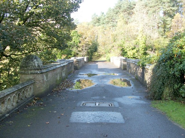
English: Overtoun Bridge. This thick-sided stone bridge, located next to 59380, has parapets on both sides; the river gorge that it crosses has sides that fall away steeply, and the river is therefore located a surprising distance below the bridge.
Overtoun House was built in 1859-63 for the Rutherglen chemical manufacturer James White (1735631), whose son became the first Lord Overtoun, but the bridge dates from 1895, and was built by H.E.Milner ["North Clyde Estuary - An Illustrated Architectural Guide", Frank Arneil Walker with Fiona Sinclair]. Although his son, John Campbell White (the aforementioned Lord Overtoun), was well known for his charitable works, he was famously lambasted in 1899 by Keir Hardie, who exposed the appalling working conditions faced by those employed in his chemical factory. [The location has featured in news reports more than once. In 1994, a mentally-disturbed man threw his two-week-old son to his death from the bridge. In October 2006, the fact that a surprising number of dogs have leapt to their death from the bridge was the subject of a television programme. This phenomenon has been reported under the sensational and misleading title of "dog suicides". Suggested explanations have ranged from the supernatural to peculiar sonic effects in the structure of the bridge; however, among the more plausible explanations is the idea that something (perhaps the scent of mink) is tempting dogs, from whose viewpoint the long drop is not apparent, to leap the bridge wall.] |
| 日期 | |
| 來源 | From geograph.org.uk |
| 作者 | Lairich Rig |
| 姓名標示 (由许可协议要求) | Lairich Rig / Overtoun Bridge / |
| 拍攝地點 | | 位於此地的本圖片與其他圖片: OpenStreetMap |
|---|
_heading:292.00&language=zh-hant)
| 目標地點 | | 位於此地的本圖片與其他圖片: OpenStreetMap |
|---|
_heading:292.00&language=zh-hant)
授權條款
[編輯]

|
此檔案採用創用CC 姓名標示-相同方式分享 2.0 通用版授權條款。
姓名標示: Lairich Rig
- 您可以自由:
- 分享 – 複製、發佈和傳播本作品
- 重新修改 – 創作演繹作品
- 惟需遵照下列條件:
- 姓名標示 – 您必須指名出正確的製作者,和提供授權條款的連結,以及表示是否有對內容上做出變更。您可以用任何合理的方式來行動,但不得以任何方式表明授權條款是對您許可或是由您所使用。
- 相同方式分享 – 如果您利用本素材進行再混合、轉換或創作,您必須基於如同原先的相同或兼容的條款,來分布您的貢獻成品。
檔案歷史
點選日期/時間以檢視該時間的檔案版本。
| 日期/時間 | 縮圖 | 尺寸 | 使用者 | 備註 | |
|---|---|---|---|---|---|
| 目前 | 2011年2月23日 (三) 14:58 | | 640 × 480(110 KB) | GeographBot(留言 | 貢獻) | == {{int:filedesc}} == {{Information |description={{en|1=Overtoun Bridge This thick-sided stone bridge, located next to 59380, has parapets on both sides; the river gorge that it crosses has sides that fall away steeply, and the river is therefore loc |
無法覆蓋此檔案。
檔案用途
下列頁面有用到此檔案:
全域檔案使用狀況
以下其他 wiki 使用了這個檔案:
- de.wikipedia.org 的使用狀況
- fa.wikipedia.org 的使用狀況
- fr.wikipedia.org 的使用狀況
- hy.wikipedia.org 的使用狀況
- it.wikipedia.org 的使用狀況
- ru.wikipedia.org 的使用狀況
- uk.wikipedia.org 的使用狀況
- www.wikidata.org 的使用狀況
- zh.wikipedia.org 的使用狀況