File:PAnke-Ring-August-2008-205.png
Jump to navigation
Jump to search

Size of this preview: 570 × 599 pixels. Other resolutions: 228 × 240 pixels | 456 × 480 pixels | 730 × 768 pixels | 1,200 × 1,262 pixels.
Original file (1,200 × 1,262 pixels, file size: 1.22 MB, MIME type: image/png)
Captions
Captions
Add a one-line explanation of what this file represents
Summary
[edit]
| Description |
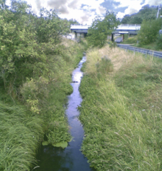
Deutsch: Die Panke durchfließt nahe Karow die Brücke des 1953 erbauten Berliner Außenringes. Der Bau des Ringes wurde durch die Teilung der Stadt nötig. Die Deutsche Reichsbahn war DDR-Bahn und die Durchfahrung von Westberlin für DDR-Bürger sollte vermieden werden. |
| Date | |
| Source | Own work |
| Author | Boonekamp |
| Camera location | | View this and other nearby images on: OpenStreetMap |
|---|
Licensing
[edit]
| I, the copyright holder of this work, release this work into the public domain. This applies worldwide. In some countries this may not be legally possible; if so: I grant anyone the right to use this work for any purpose, without any conditions, unless such conditions are required by law. |
File history
Click on a date/time to view the file as it appeared at that time.
| Date/Time | Thumbnail | Dimensions | User | Comment | |
|---|---|---|---|---|---|
| current | 17:13, 8 December 2008 | | 1,200 × 1,262 (1.22 MB) | Boonekamp (talk | contribs) | {{Information |Description={{de|1=Die Panke durchfließt nahe Karow die Brücke des 1953 erbauten Berliner Außenringes. Der Bau des Ringes wurde durch die Teilung der Stadt nötig. Die Deutsche Reichsbahn war DDR-Bahn und die Durchfahrung von Westberlin |
You cannot overwrite this file.
File usage on Commons
The following page uses this file: