File:PIA21315 - Bermuda.jpg

Original file (2,385 × 1,968 pixels, file size: 720 KB, MIME type: image/jpeg)
Captions
Captions
Summary[edit]
| Description |
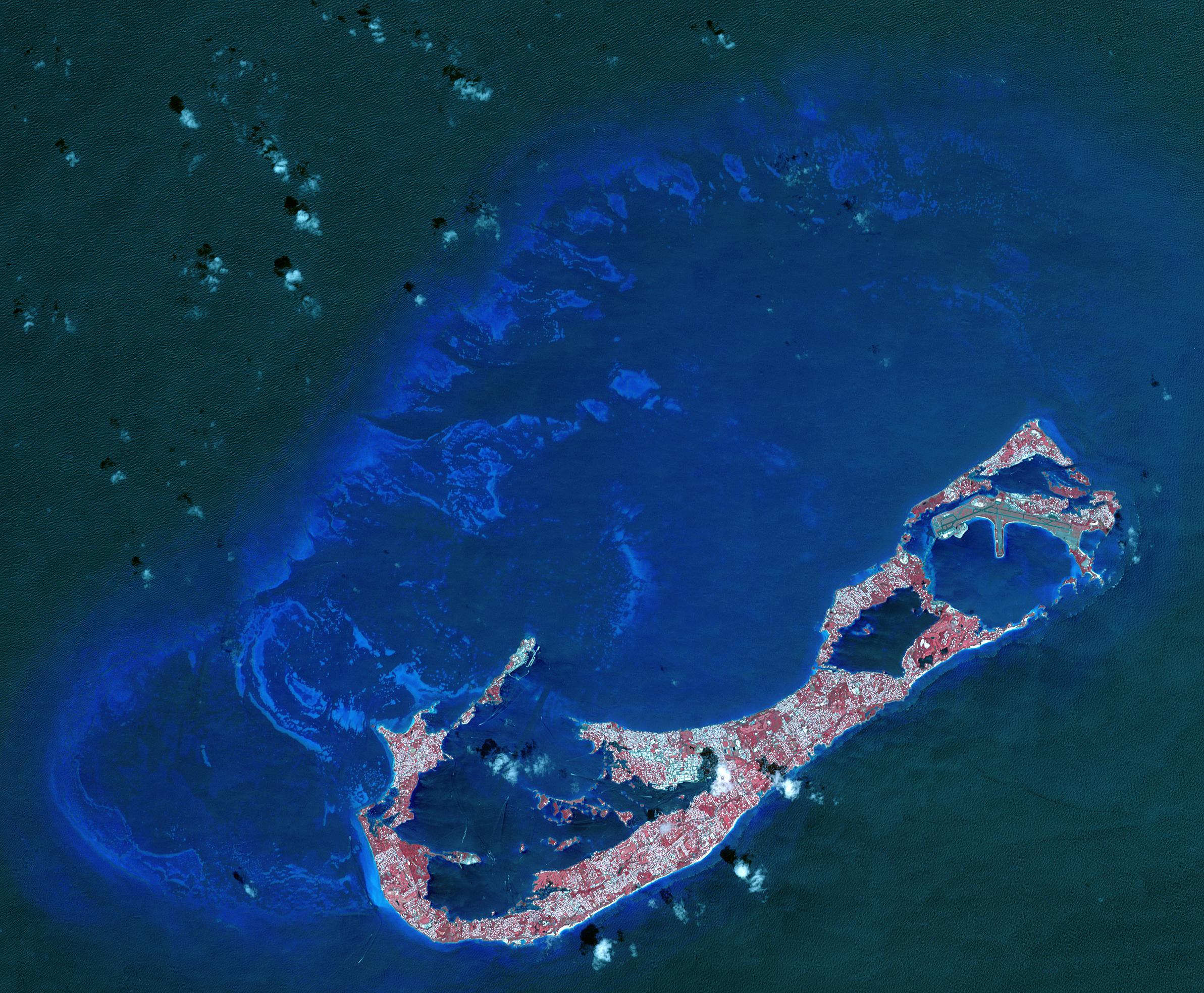
English: Bermuda is a British Overseas Territory in the western Atlantic off the east coast of North America. The uninhabited islands were first discovered in 1503 by the Spanish explorer Juan de Bermudez. In 1609 the English Virginia Colony settled Bermuda, and it has remained a British colony for over 400 years. Bermuda's economy is dominated by offshore insurance, and tourism, resulting in a very high GDP per capita. The image was acquired April 19, 2009, covers an area of 29.4 by 40.7 kilometers, and is located at 32.3 degrees north, 64.8 degrees west.
With its 14 spectral bands from the visible to the thermal infrared wavelength region and its high spatial resolution of 15 to 90 meters (about 50 to 300 feet), ASTER images Earth to map and monitor the changing surface of our planet. ASTER is one of five Earth-observing instruments launched Dec. 18, 1999, on Terra. The instrument was built by Japan's Ministry of Economy, Trade and Industry. A joint U.S./Japan science team is responsible for validation and calibration of the instrument and data products. The broad spectral coverage and high spectral resolution of ASTER provides scientists in numerous disciplines with critical information for surface mapping and monitoring of dynamic conditions and temporal change. Example applications are: monitoring glacial advances and retreats; monitoring potentially active volcanoes; identifying crop stress; determining cloud morphology and physical properties; wetlands evaluation; thermal pollution monitoring; coral reef degradation; surface temperature mapping of soils and geology; and measuring surface heat balance. The U.S. science team is located at NASA's Jet Propulsion Laboratory, Pasadena, Calif. The Terra mission is part of NASA's Science Mission Directorate, Washington, D.C. More information about ASTER is available at http://asterweb.jpl.nasa.gov/. |
| Date | 19 April 2009 (published 15 February 2017) |
| Source | Catalog page · Full-res (JPEG · TIFF) |
| Author | NASA/METI/AIST/Japan Space Systems, and U.S./Japan ASTER Science Team |
| Camera location | | View this and other nearby images on: OpenStreetMap |
|---|
This image or video was catalogued by Jet Propulsion Laboratory of the United States National Aeronautics and Space Administration (NASA) under Photo ID: PIA21315. This tag does not indicate the copyright status of the attached work. A normal copyright tag is still required. See Commons:Licensing. Other languages:
|
| This media is a product of the Terra mission Credit and attribution belongs to the Advanced Spaceborne Thermal Emission and Reflection Radiometer (ASTER) team, NASA/METI/AIST/Japan Space Systems |
Licensing[edit]
| This file is in the public domain in the United States because it was solely created by NASA. NASA copyright policy states that "NASA material is not protected by copyright unless noted". (See Template:PD-USGov, NASA copyright policy page or JPL Image Use Policy.) | ||
 |
Warnings:
|
File history
Click on a date/time to view the file as it appeared at that time.
| Date/Time | Thumbnail | Dimensions | User | Comment | |
|---|---|---|---|---|---|
| current | 05:06, 16 February 2017 | | 2,385 × 1,968 (720 KB) | PhilipTerryGraham (talk | contribs) | User created page with UploadWizard |
You cannot overwrite this file.
File usage on Commons
The following page uses this file: