File:PIA22348 – Formations in Context (or, what is it?).jpg

Original file (2,736 × 1,824 pixels, file size: 718 KB, MIME type: image/jpeg)
Captions
Captions
Summary
[edit].jpg&action=edit§ion=1)
| Description |
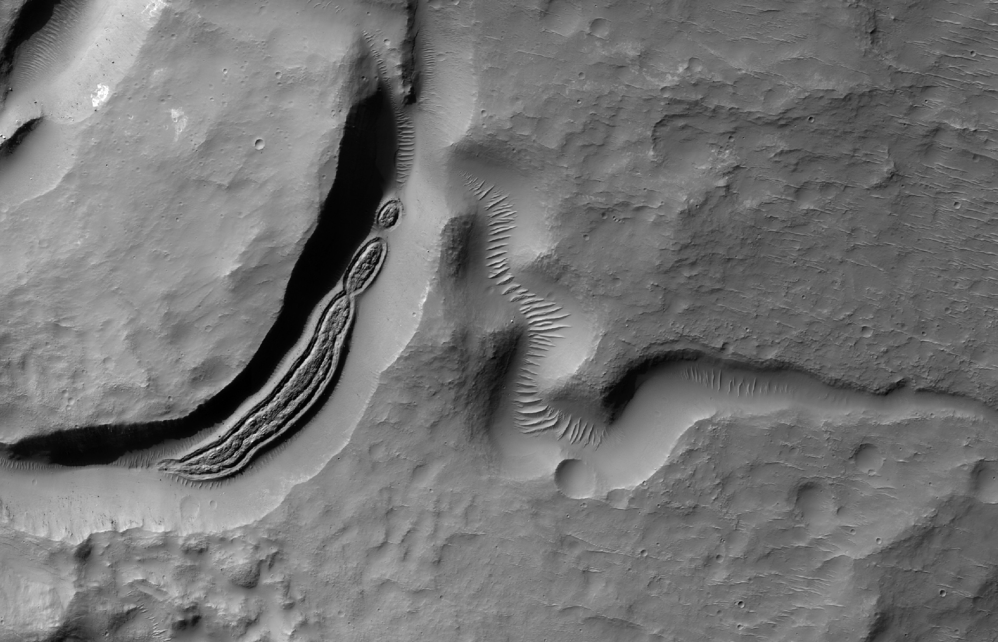
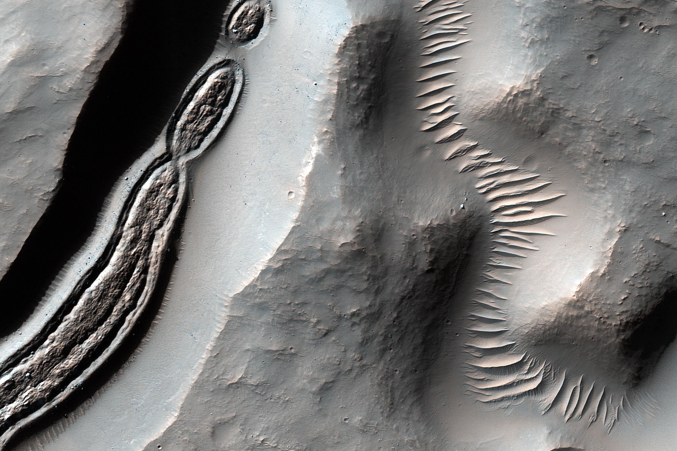
English: This image from NASA's Mars Reconnaissance Orbiter is a close-up of a trough, along with channels draining into the depression. Some HiRISE images show strange-looking formations. Sometimes it helps to look at Context Camera images to understand the circumstances of a scene -- like this cutout from CTX 033783_1509 -- which here shows an impact crater with a central peak, and a collapse depression with concentric troughs just north of that peak.
On the floor of the trough is some grooved material that we typically see in middle latitude regions where there has been glacial flow. These depressions with concentric troughs exist elsewhere on Mars, and their origins remain a matter of debate. NB: The Context Camera is another instrument onboard MRO, and it has a larger viewing angle than HiRISE, but less resolution capability than our camera. The map is projected here at a scale of 50 centimeters (19.7 inches) per pixel. [The original image scale is 51.3 centimeters (20.2 inches) per pixel (with 2 x 2 binning); objects on the order of 154 centimeters (60.6 inches) across are resolved.] North is up. The University of Arizona, Tucson, operates HiRISE, which was built by Ball Aerospace & Technologies Corp., Boulder, Colorado. NASA's Jet Propulsion Laboratory, a division of Caltech in Pasadena, California, manages the Mars Reconnaissance Orbiter Project for NASA's Science Mission Directorate, Washington. |
| Date | 12 January 2018 (published 2 April 2018) |
| Source | Catalog page · Full-res (JPEG · TIFF) |
| Author | NASA/JPL-Caltech/Univ. of Arizona |
| Location on Mars | View this and other nearby images on: Google Maps |
|---|
.jpg¶ms=-28.330000_N_0083.487000_E_globe:Mars__&language=en)
This image or video was catalogued by Jet Propulsion Laboratory of the United States National Aeronautics and Space Administration (NASA) under Photo ID: PIA22348. This tag does not indicate the copyright status of the attached work. A normal copyright tag is still required. See Commons:Licensing. Other languages:
|
 |
This media is a product of the Mars Reconnaissance Orbiter mission Credit and attribution belongs to the High Resolution Imaging Science Experiment (HiRISE) team, NASA/JPL-Caltech/Univ. of Arizona |
Licensing
[edit].jpg&action=edit§ion=2)
| This file is in the public domain in the United States because it was solely created by NASA. NASA copyright policy states that "NASA material is not protected by copyright unless noted". (See Template:PD-USGov, NASA copyright policy page or JPL Image Use Policy.) | ||
 |
Warnings:
|
File history
Click on a date/time to view the file as it appeared at that time.
| Date/Time | Thumbnail | Dimensions | User | Comment | |
|---|---|---|---|---|---|
| current | 19:20, 16 April 2018 | | 2,736 × 1,824 (718 KB) | PhilipTerryGraham (talk | contribs) | User created page with UploadWizard |
You cannot overwrite this file.
File usage on Commons
The following page uses this file:
.jpg&oldid=910960239)