File:PPN749483423 Plan von Hamburg, Altona und Umgebung (1885).tif
Jump to navigation
Jump to search

Size of this JPG preview of this TIF file: 762 × 600 pixels. Other resolutions: 305 × 240 pixels | 610 × 480 pixels | 976 × 768 pixels | 1,280 × 1,007 pixels | 2,560 × 2,014 pixels | 7,549 × 5,940 pixels.
Original file (7,549 × 5,940 pixels, file size: 25.18 MB, MIME type: image/tiff)
Captions
Captions
Add a one-line explanation of what this file represents
Summary
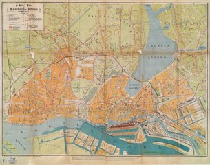
[edit]| Title |
Plan von Hamburg, Altona und Umgebung nebst Ansichten, Text, Straßenverzeichnis etc. ; mit Special-Angaben betr.: Zollanschluß |
||||||||||||||||||||||||||
| Description |
Mit Ansichten auf der Rücks. |
||||||||||||||||||||||||||
| Date | |||||||||||||||||||||||||||
| Source | http://resolver.sub.uni-hamburg.de/goobi/PPN749483423 | ||||||||||||||||||||||||||
| Creator |
Unknown author |
||||||||||||||||||||||||||
| Geotemporal data | |||||||||||||||||||||||||||
| Scale | [ Ca. 1:12.000] | ||||||||||||||||||||||||||
| Georeferencing | If inappropriate please set warp_status = skip to hide. | ||||||||||||||||||||||||||
| Bibliographic data | |||||||||||||||||||||||||||
| Place of publication | Hamburg | ||||||||||||||||||||||||||
| Publisher |
Adler |
||||||||||||||||||||||||||
| Archival data | |||||||||||||||||||||||||||
| Collection |
|
||||||||||||||||||||||||||
| Accession number | |||||||||||||||||||||||||||
| Dimensions | 53 x 40 cm, gefaltet | ||||||||||||||||||||||||||
| Medium | Lithographie (mehrfarb.), 1 Kt | ||||||||||||||||||||||||||
| Other versions |
.jpg) |
||||||||||||||||||||||||||

Licensing
[edit]|
This is a faithful photographic reproduction of a two-dimensional, public domain work of art. The work of art itself is in the public domain for the following reason:
The official position taken by the Wikimedia Foundation is that "faithful reproductions of two-dimensional public domain works of art are public domain".
This photographic reproduction is therefore also considered to be in the public domain in the United States. In other jurisdictions, re-use of this content may be restricted; see Reuse of PD-Art photographs for details. | ||||
File history
Click on a date/time to view the file as it appeared at that time.
| Date/Time | Thumbnail | Dimensions | User | Comment | |
|---|---|---|---|---|---|
| current | 10:36, 13 April 2019 |  | 7,549 × 5,940 (25.18 MB) | RKBot (talk | contribs) | =={{int:filedesc}}== {{Map |title = Plan von Hamburg, Altona und Umgebung nebst Ansichten, Text, Straßenverzeichnis etc. ; mit Special-Angaben betr.: Zollanschluß |description = Mit Ansichten auf der Rücks. |legend = |author = {{unknown}} |date = 1885 |source = http://resolver.sub.uni-hamburg.de/goobi/PPN749483423 |permission = |map date = |location = |projection = |scale = [ Ca. 1... |
You cannot overwrite this file.
File usage on Commons
The following page uses this file: