File:Palestine governorates.png
跳至導覽
跳至搜尋
預覽大小:515 × 599 像素。 其他解析度:206 × 240 像素 | 413 × 480 像素 | 755 × 878 像素。
原始檔案 (755 × 878 像素,檔案大小:23 KB,MIME 類型:image/png)
說明
說明
添加單行說明來描述出檔案所代表的內容
摘要
[編輯]
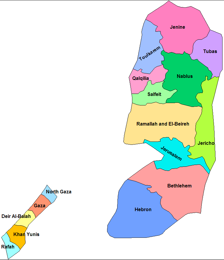
| 描述 | Map of the governorates of Palestine. Created by Rarelibra 21:51, 17 April 2007 (UTC) for public domain use, using MapInfo Professinal v8.5 and various mapping resources. |
| 日期 | 2007年4月17日 (原始上傳日期) |
| 來源 | No machine-readable source provided. Own work assumed (based on copyright claims). |
| 作者 | No machine-readable author provided. Rarelibra assumed (based on copyright claims). |
授權條款
[編輯]
| 我,此作品的版權所有人,釋出此作品至公共領域。此授權條款在全世界均適用。 這可能在某些國家不合法,如果是的話: 我授予任何人有權利使用此作品於任何用途,除受法律約束外,不受任何限制。 |
檔案歷史
點選日期/時間以檢視該時間的檔案版本。
| 日期/時間 | 縮圖 | 尺寸 | 使用者 | 備註 | |
|---|---|---|---|---|---|
| 目前 | 2007年7月3日 (二) 00:37 | | 755 × 878(23 KB) | Timeshifter(留言 | 貢獻) | Cropped image of original creator/uploader to eliminate white space to left and right. Original creator released image under <nowiki>{{PD-self}}</nowiki> |
| 2007年4月17日 (二) 21:51 |  | 1,281 × 878(26 KB) | Rarelibra(留言 | 貢獻) | Map of the governorates of Palestine (Palestinian Occupied Territory). Created by ~~~~ for public domain use, using MapInfo Professinal v8.5 and various mapping resources. |
無法覆蓋此檔案。
檔案用途
下列頁面有用到此檔案:
全域檔案使用狀況
以下其他 wiki 使用了這個檔案:
- arz.wikipedia.org 的使用狀況
- ast.wikipedia.org 的使用狀況
- ca.wikipedia.org 的使用狀況
- Franja de Gaza
- Cisjordània
- Estat de Palestina
- Governació de Gaza Nord
- Plantilla:Governacions Palestina
- Governació de Gaza
- Governació de Deir al-Balah
- Governació de Khan Yunis
- Governació de Rafah
- Governació de Jerusalem
- Governació de Betlem
- Governació d'Hebron
- Governació de Ramal·lah i al-Bireh
- Governació de Jericó
- Governació de Salfit
- Governació de Nablus
- Governació de Qalqilya
- Governació de Tubas
- Governació de Tulkarem
- Governació de Jenin
- Governacions de Palestina
- en.wikipedia.org 的使用狀況
- Governorates of Palestine
- Jerusalem Governorate
- Jenin Governorate
- Template:Governorates of the State of Palestine
- Nablus Governorate
- Bethlehem Governorate
- North Gaza Governorate
- Qalqilya Governorate
- Jericho Governorate
- Template talk:Governorates of the State of Palestine
- Hebron Governorate
- Rafah Governorate
- Tubas Governorate
- Ramallah and al-Bireh Governorate
- Gaza Governorate
- Khan Yunis Governorate
- Tulkarm Governorate
- Deir al-Balah Governorate
- Salfit Governorate
- User:Kharbaan Ghaltaan/sandbox
- User:Falcaorib/Israel and Palestine
- es.wikipedia.org 的使用狀況
- eu.wikipedia.org 的使用狀況
檢視此檔案的更多全域使用狀況。