File:Pam 2015-03-13 0220Z.jpg
Jump to navigation
Jump to search

Size of this preview: 450 × 600 pixels. Other resolutions: 180 × 240 pixels | 360 × 480 pixels | 576 × 768 pixels | 768 × 1,024 pixels | 1,536 × 2,048 pixels | 6,300 × 8,400 pixels.
Original file (6,300 × 8,400 pixels, file size: 10.86 MB, MIME type: image/jpeg)
Captions
Captions
Add a one-line explanation of what this file represents
Summary
[edit]
| Description |
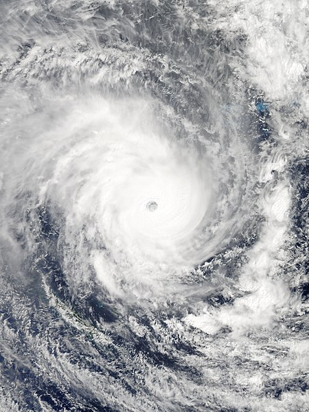
English: Severe Tropical Cyclone Pam over Vanuatu and nearing peak intensity on 13 March 2015. Español: El ciclón tropical Pam cerca de su pico de intensidad localizado al este de Vanuatu, el 13 de marzo de 2015. |
| Date | |
| Source | EOSDIS Worldview |
| Author | MODIS image captured by NASA’s Aqua satellite |
| Camera location | | View this and other nearby images on: OpenStreetMap |
|---|
Licensing
[edit]
| This file is in the public domain in the United States because it was solely created by NASA. NASA copyright policy states that "NASA material is not protected by copyright unless noted". (See Template:PD-USGov, NASA copyright policy page or JPL Image Use Policy.) | ||
 |
Warnings:
|
File history
Click on a date/time to view the file as it appeared at that time.
| Date/Time | Thumbnail | Dimensions | User | Comment | |
|---|---|---|---|---|---|
| current | 16:44, 12 April 2017 | | 6,300 × 8,400 (10.86 MB) | Meow (talk | contribs) | Directly optimised the image from Worldview. |
| 15:34, 13 March 2015 |  | 6,800 × 8,800 (5.94 MB) | Meow (talk | contribs) | Gallery version | |
| 12:58, 13 March 2015 |  | 6,721 × 7,524 (21.73 MB) | TheAustinMan (talk | contribs) | Increase saturation/contrast | |
| 05:42, 13 March 2015 |  | 6,401 × 8,321 (3.75 MB) | Byralaal (talk | contribs) | User created page with UploadWizard |
You cannot overwrite this file.
File usage on Commons
The following 2 pages use this file:
File usage on other wikis
The following other wikis use this file:
- Usage on ca.wikipedia.org
- Usage on de.wikipedia.org
- Usage on en.wikipedia.org
- Usage on es.wikipedia.org
- Usage on fi.wikipedia.org
- Usage on fr.wikipedia.org
- Usage on ja.wikipedia.org
- Usage on ko.wikipedia.org
- Usage on ml.wikipedia.org
- Usage on pl.wikipedia.org
- Usage on pt.wikipedia.org
- Usage on sr.wikipedia.org
- Usage on th.wikipedia.org
- Usage on vi.wikipedia.org
- Usage on www.wikidata.org
- Usage on zh.wikipedia.org