File:Panorama Mittenwalder Höhenweg.jpg
Jump to navigation
Jump to search

Size of this preview: 800 × 115 pixels. Other resolutions: 320 × 46 pixels | 640 × 92 pixels | 1,024 × 147 pixels | 1,280 × 183 pixels | 9,918 × 1,420 pixels.
Original file (9,918 × 1,420 pixels, file size: 2.71 MB, MIME type: image/jpeg)
Captions
Captions
Add a one-line explanation of what this file represents
| Description |
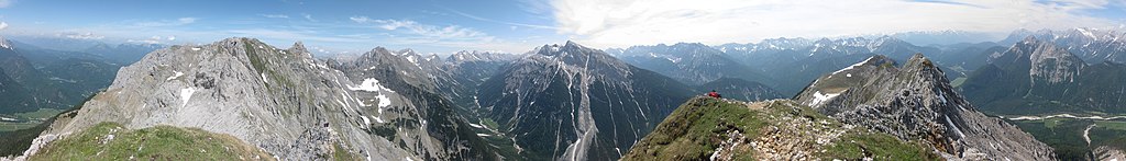
Deutsch: 360°-Panorama von der Sulzleklammspitze (2323 m). Von links nach rechts: Mittenwalder Höhenweg, Karwendelbachtal, Pleisenspitze (2567 m; Bildmitte), Kirchlspitze (2302 m), Große Arnspitze (2196 m; Gipfel rechts hinten), Wettersteingebirge (Massiv rechts im Hintergrund).
English: 360° panorama from Sulzleklammspitze (2323 m). From left to right: Mittenwalder Höhenweg, Karwendelbachtal, Pleisenspitze (2567 m; center), Kirchlspitze (2302 m), Große Arnspitze (2196 m), Wetterstein (mountain range in the background at the right border).
This image was created with Hugin. |
||
| Date | |||
| Source | Own work | ||
| Author | Thorsten Hartmann |

| 360° | View in 360° panoramic viewer
|
|---|
| Camera location | | View this and other nearby images on: OpenStreetMap |
|---|
I, the copyright holder of this work, hereby publish it under the following licenses:

|
Permission is granted to copy, distribute and/or modify this document under the terms of the GNU Free Documentation License, Version 1.2 or any later version published by the Free Software Foundation; with no Invariant Sections, no Front-Cover Texts, and no Back-Cover Texts. A copy of the license is included in the section entitled GNU Free Documentation License. |
| This file is licensed under the Creative Commons Attribution-Share Alike 3.0 Unported license. | ||
| ||
| This licensing tag was added to this file as part of the GFDL licensing update. |
This file is licensed under the Creative Commons Attribution-Share Alike 2.0 Germany license.
- You are free:
- to share – to copy, distribute and transmit the work
- to remix – to adapt the work
- Under the following conditions:
- attribution – You must give appropriate credit, provide a link to the license, and indicate if changes were made. You may do so in any reasonable manner, but not in any way that suggests the licensor endorses you or your use.
- share alike – If you remix, transform, or build upon the material, you must distribute your contributions under the same or compatible license as the original.

You may select the license of your choice.
| Annotations | This image is annotated: View the annotations at Commons |
File history
Click on a date/time to view the file as it appeared at that time.
| Date/Time | Thumbnail | Dimensions | User | Comment | |
|---|---|---|---|---|---|
| current | 00:06, 20 June 2009 | 9,918 × 1,420 (2.71 MB) | Thgoiter (talk | contribs) | {{Information |Description={{de|360°-Panorama von der Sulzleklammspitze (2323 m). Von links nach rechts: Mittenwalder Höhenweg, Karwendelbachtal, Pleisenspitze (2567 m; Bildmitte), Kirchlspitze (2302 |
You cannot overwrite this file.
File usage on Commons
The following 4 pages use this file:
File usage on other wikis
The following other wikis use this file:
- Usage on bg.wikipedia.org
- Usage on de.wikipedia.org
- Usage on es.wikipedia.org