File:Parinacota Volcano, South America.JPG
跳至導覽
跳至搜尋

預覽大小:800 × 531 像素。 其他解析度:320 × 213 像素 | 640 × 425 像素 | 1,024 × 680 像素 | 1,280 × 850 像素 | 2,560 × 1,700 像素 | 4,288 × 2,848 像素。
原始檔案 (4,288 × 2,848 像素,檔案大小:10.67 MB,MIME 類型:image/jpeg)
說明
說明
添加單行說明來描述出檔案所代表的內容
摘要
[編輯]
| 描述 |
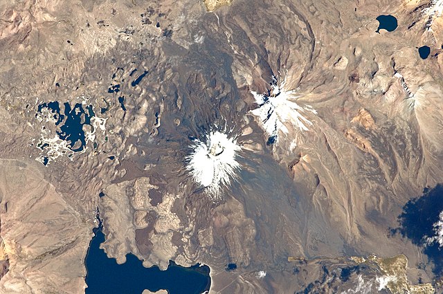
English: This astronaut photograph from the International Space Station highlights the symmetrical cone of Parinacota, with its well-developed summit crater (elevation 6,348 meters above sea level). Dark brown to dark gray surfaces to the east and west of the summit include lava flows, pyroclastic deposits, and ash.
A companion volcano, Pomerape, is located across a low saddle to the north. This volcano last erupted during the Pleistocene Epoch (approximately 3 million to 12,000 years ago). Together, Parinacota and Pomerape form the Nevados de Payachata volcanic area. The summits of both volcanoes are covered by white snowpack and small glaciers. Eruptive activity at Parinacota has directly influenced development of the local landscape, beyond the placement of volcanic deposits. Approximately 8,000 years ago, the western flank of the volcano collapsed, creating a debris avalanche that travelled 22 kilometres to the west. The debris blocked rivers and streams, leading to the formation of Chungará Lake to the south (lower left). The uneven, hummocky surface of the avalanche debris provides ample catchments for water, as evidenced by the numerous small ponds and Cotacotani Lake to the west. |
| 日期 | |
| 來源 | NASA Earth Observatory |
| 作者 | ISS Expedition 29 crew |
| 拍攝地點 | | 位於此地的本圖片與其他圖片: OpenStreetMap |
|---|
本圖像或影音收錄於美國國家航空暨太空總署 (NASA)休士頓太空中心(Johnson Space Center),其照片編號為: ISS029-E-20003 此標籤不表示文件的著作權狀態。任何文件在附有此標籤的同時還需要一個有效的著作權標籤。請參閱許可協議說明頁面以了解更多資訊。 其他語言:
|
Image acquired with a Nikon D2Xs digital camera using a 400 mm lens, and is provided by the ISS Crew Earth Observations experiment and Image Science & Analysis Laboratory, Johnson Space Center.
授權條款
[編輯]
| 本作品由NASA創作,屬於公有領域。根據NASA的版權政策:“NASA的創作除非另有聲明否則不受版權保護。”(參見:Template:PD-USGov/zh,NASA版權政策或JPL圖像使用政策) | ||
 |
警告:
|
| 註解 | 該圖片含有註解:在維基媒體共享資源上查看註解 |
檔案歷史
點選日期/時間以檢視該時間的檔案版本。
| 日期/時間 | 縮圖 | 尺寸 | 使用者 | 備註 | |
|---|---|---|---|---|---|
| 目前 | 2011年10月17日 (一) 13:26 | | 4,288 × 2,848(10.67 MB) | Originalwana(留言 | 貢獻) | {{Information |Description ={{en|1=This astronaut photograph from the International Space Station highlights the symmetrical cone of Parinacota, with its well-developed summit crater (elevation 6,348 meters above sea level). Dark brown to dark |
無法覆蓋此檔案。
檔案用途
沒有使用此檔案的頁面。
全域檔案使用狀況
以下其他 wiki 使用了這個檔案:
- bs.wikipedia.org 的使用狀況
- en.wikipedia.org 的使用狀況
- ja.wikipedia.org 的使用狀況
- lld.wikipedia.org 的使用狀況
- www.wikidata.org 的使用狀況
- zh.wikipedia.org 的使用狀況