File:Paris Metro map.svg
跳至導覽
跳至搜尋

此 SVG 檔案的 PNG 預覽的大小:653 × 600 像素。 其他解析度:261 × 240 像素 | 523 × 480 像素 | 836 × 768 像素 | 1,115 × 1,024 像素 | 2,230 × 2,048 像素 | 1,927 × 1,770 像素。
原始檔案 (SVG 檔案,表面大小:1,927 × 1,770 像素,檔案大小:309 KB)
說明
說明
添加單行說明來描述出檔案所代表的內容
| 描述 |
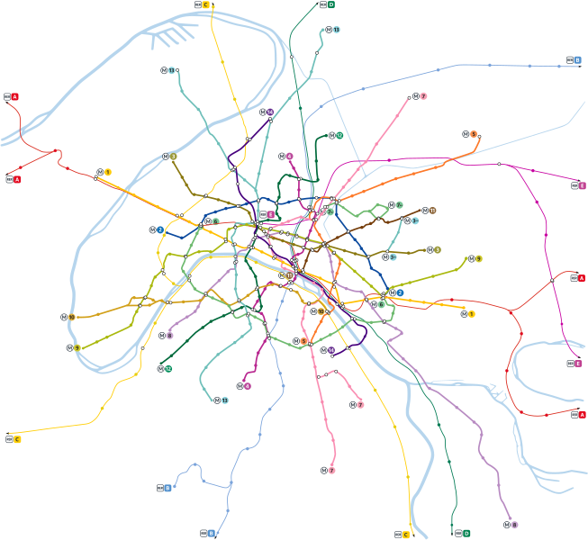
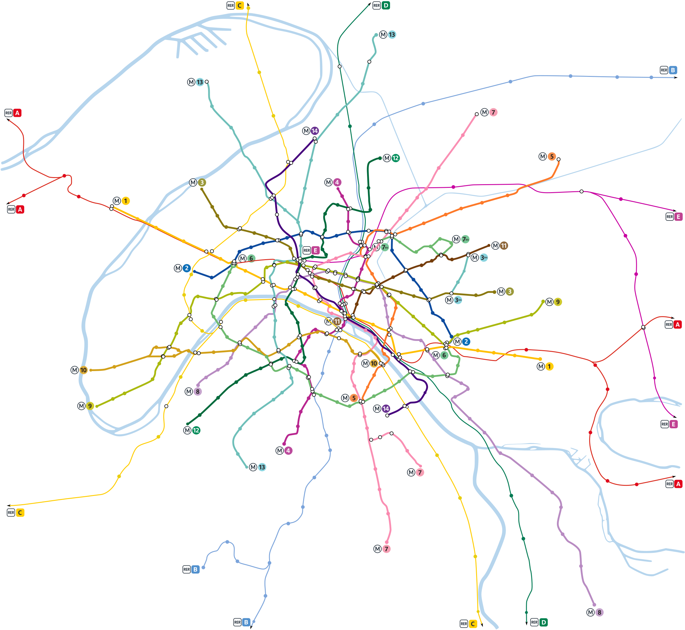
English: Paris metro network pictured at a geographically accurate scale.
Français : Plan du métro de Paris en repectant les proportions géographiques.
Русский: Карта парижского метрополитена и сети RER в географическом масштабе. |
||
| 日期 | |||
| 來源 | Vectorisation of Image:Paris Metro map.gif | ||
| 作者 | User:Pmx | ||
| 授權許可 (重用此檔案) |
|
||
| 其他版本 |
  |
檔案歷史
點選日期/時間以檢視該時間的檔案版本。
| 日期/時間 | 縮圖 | 尺寸 | 用戶 | 備註 | |
|---|---|---|---|---|---|
| 目前 | 2022年5月14日 (六) 08:35 | | 1,927 × 1,770(309 KB) | Lyon-St-Clair(對話 | 貢獻) | New line signs since 2019/2020 |
| 2021年1月18日 (一) 09:33 |  | 1,927 × 1,770(326 KB) | Julio974fr(對話 | 貢獻) | New extensions | |
| 2010年1月10日 (日) 11:25 |  | 1,927 × 1,770(342 KB) | Greenski(對話 | 貢獻) | Using of the goods paris metro signs, changing rer A color. | |
| 2008年6月22日 (日) 00:54 |  | 1,927 × 1,770(321 KB) | Gonioul(對話 | 貢獻) | split to multiple layers, thickens metro paths | |
| 2008年6月21日 (六) 22:16 |  | 1,927 × 1,770(222 KB) | Gonioul(對話 | 貢獻) | grey background is bad for readability | |
| 2008年6月13日 (五) 18:46 |  | 1,927 × 1,770(222 KB) | Otourly(對話 | 貢獻) | Mise à jour | |
| 2007年7月13日 (五) 20:59 |  | 1,927 × 1,770(219 KB) | Pmx(對話 | 貢獻) | {{Information |Description= {{en|Paris metro network pictured at a geographically accurate scale.}} {{fr|Plan du métro de Paris en vrai grandeur.}} |Source=Vectorisation of Image:Paris Metro map.gif |Date=13/07/07 |Author=User:Pmx |Permission=PD |
無法覆蓋此檔案。
檔案用途
下列11個頁面有用到此檔案:
- Maps of Paris
- Paris Metro
- User:Chumwa/OgreBot/Public transport information/2021 January 11-20
- User:Chumwa/OgreBot/Public transport information/2022 May 11-20
- User:Chumwa/OgreBot/Transport Maps/2021 January 11-20
- User:Chumwa/OgreBot/Transport Maps/2022 May 11-20
- User:Paris 16/Paris
- User talk:Pi.1415926535/Archive 1
- File:Paris Metro map.gif
- File:Paris Metro map beschriftet.png
- File:Paris Metro map complete.svg
全域檔案使用狀況
以下其他 wiki 使用了這個檔案:
- cs.wikipedia.org 的使用狀況
- de.wikipedia.org 的使用狀況
- fr.wikipedia.org 的使用狀況
- Métro de Paris
- Portail:Transports en Île-de-France
- Portail:Transports en Île-de-France/Introduction
- Portail:Transports en Île-de-France/Métro
- Wikipédia:Atelier graphique/Images à améliorer/Archives/Juin 2008
- Wikipédia:Atelier graphique/Cartes/Archives/Demandes mises en sommeil
- Wikipédia:Atelier graphique/Cartes/Archives/juillet 2009
- Réseau (homonymie)
- Wikipédia:Atelier graphique/Cartes/Archives/juin 2016
- it.wikipedia.org 的使用狀況
- pl.wikipedia.org 的使用狀況
- zh.wikipedia.org 的使用狀況