File:Parker's sectional & geological map of Iowa exhibiting her iron, lead, copper, coal and other geological resources and all rail roads completed in progress, and projected compiled from the U.S. LOC 98688479.jpg
Jump to navigation
Jump to search

Size of this preview: 800 × 551 pixels. Other resolutions: 320 × 220 pixels | 640 × 441 pixels | 1,024 × 705 pixels | 1,280 × 881 pixels | 2,560 × 1,762 pixels | 14,432 × 9,936 pixels.
Original file (14,432 × 9,936 pixels, file size: 26.65 MB, MIME type: image/jpeg)
Captions
Captions
Add a one-line explanation of what this file represents
Summary
[edit]| Warning | The original file is very high-resolution. It might not load properly or could cause your browser to freeze when opened at full size. |
|---|
| Description |
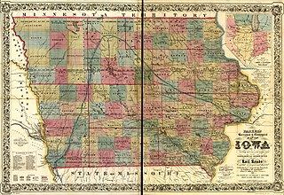
English: Names of railroads are listed at lower left of map. |
||
| Title | Parker's sectional & geological map of Iowa exhibiting her iron, lead, copper, coal and other geological resources and all rail roads completed in progress, and projected compiled from the U.S. surveys and personal reconnoisance. By Nathan H. Parker author of "Iowa As It Is" Clinton Io. 1856. | ||
| Shelf ID | G4151.H1 1856 .P31 | ||
| Date | |||
| Source | https://www.loc.gov/item/98688479/ | ||
| Author | Parker, Nathan H. (Nathan Howe); Parker, Nathan H. | ||
| Permission (Reusing this file) |
|
||
| Other versions |
|
||
| Location | United States · Iowa | ||
| Part of | American Memory · Catalog · Railroad Maps, 1828-1900 · Geography And Map Division · Transportation And Communication | ||
| Subject | United States · Mines And Mineral Resources · Iowa · Railroads · Maps |


Licensing
[edit]
|
This is a faithful photographic reproduction of a two-dimensional, public domain work of art. The work of art itself is in the public domain for the following reason:
The official position taken by the Wikimedia Foundation is that "faithful reproductions of two-dimensional public domain works of art are public domain".
This photographic reproduction is therefore also considered to be in the public domain in the United States. In other jurisdictions, re-use of this content may be restricted; see Reuse of PD-Art photographs for details. | ||||
File history
Click on a date/time to view the file as it appeared at that time.
| Date/Time | Thumbnail | Dimensions | User | Comment | |
|---|---|---|---|---|---|
| current | 06:25, 3 June 2018 | | 14,432 × 9,936 (26.65 MB) | Fæ (talk | contribs) | LOC Maps https://www.loc.gov/item/98688479/ #18682 |
You cannot overwrite this file.
File usage on Commons
The following 2 pages use this file: