File:Part of DeKalb and Fulton County, Ga. - compiled for the use of the Topographical Engrs. from the original land map & surveys of DeKalb County LOC 2006459240.jpg
Jump to navigation
Jump to search

Size of this preview: 800 × 430 pixels. Other resolutions: 320 × 172 pixels | 640 × 344 pixels | 1,024 × 551 pixels | 1,280 × 688 pixels | 2,560 × 1,377 pixels | 11,185 × 6,016 pixels.
Original file (11,185 × 6,016 pixels, file size: 6.99 MB, MIME type: image/jpeg)
Captions
Captions
Add a one-line explanation of what this file represents
Summary
[edit]| Description |
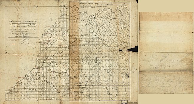
English: Relief shown by hachures. Originally printed on 2 sheets, 54 x 40 cm. and 53 x 34 cm., sheets joined to form 1 map. LC Civil War maps (2nd ed.), S77 Available also through the Library of Congress Web site as a raster image. Note on western sheet: "Note. The topographical engineers are directed to return as soon as possible one copy of this land map with all the information they are able to obtain, to this office. Corps Engineers will cause a speedy compilation." In pencil on verso: "Dear Bill [believed to be Col. William E. Merrill], This is the only map I have of the country you want-If you have any way to have it traced to night please do so and either return this or the tracing. My office is in Marietta. No one here with me or I would have it traced my self. If you cannot trace it keep it. [signed] Harry C. Wharton." Map drawn on a numbered 9/16 in. grid. Includes names of select landowners. Annotations in pencil, red pencil, blue pencil, and red ink. Printed at lower-center of right sheet: 18. LC copy imperfect: Fold-lined, minor losses along folds. |
||
| Title | Part of DeKalb and Fulton County, Ga. : compiled for the use of the Topographical Engrs. from the original land map & surveys of DeKalb County | ||
| Shelf ID | G3923.D5 1864 .U62 | ||
| Date | |||
| Source | https://www.loc.gov/item/2006459240/ | ||
| Author | United States. Army. Department Of The Cumberland. Topographical Engineers | ||
| Permission (Reusing this file) |
|
||
| Other versions |
|
||
| Location | United States · Dekalb County · Fulton County · Georgia | ||
| Part of | Civil War Maps · County Landownership Maps · Cultural Landscapes · Military Battles And Campaigns · Catalog · American Memory · Geography And Map Division | ||
| Subject | Georgia · Dekalb County · Dekalb County (Ga.) · United States · Maps · Fulton County · Fulton County (Ga.) · Landowners |


Licensing
[edit]
|
This is a faithful photographic reproduction of a two-dimensional, public domain work of art. The work of art itself is in the public domain for the following reason:
The official position taken by the Wikimedia Foundation is that "faithful reproductions of two-dimensional public domain works of art are public domain".
This photographic reproduction is therefore also considered to be in the public domain in the United States. In other jurisdictions, re-use of this content may be restricted; see Reuse of PD-Art photographs for details. | ||||
File history
Click on a date/time to view the file as it appeared at that time.
| Date/Time | Thumbnail | Dimensions | User | Comment | |
|---|---|---|---|---|---|
| current | 07:50, 11 May 2018 | | 11,185 × 6,016 (6.99 MB) | Fæ (talk | contribs) | LOC Maps https://www.loc.gov/item/2006459240/ #8450 |
You cannot overwrite this file.
File usage on Commons
The following page uses this file: