File:Patras 1772.jpg
Jump to navigation
Jump to search

Size of this preview: 800 × 509 pixels. Other resolutions: 320 × 204 pixels | 640 × 407 pixels | 1,051 × 669 pixels.
Original file (1,051 × 669 pixels, file size: 33 KB, MIME type: image/jpeg)
Captions
Captions
Add a one-line explanation of what this file represents
Summary
[edit]
| Description |
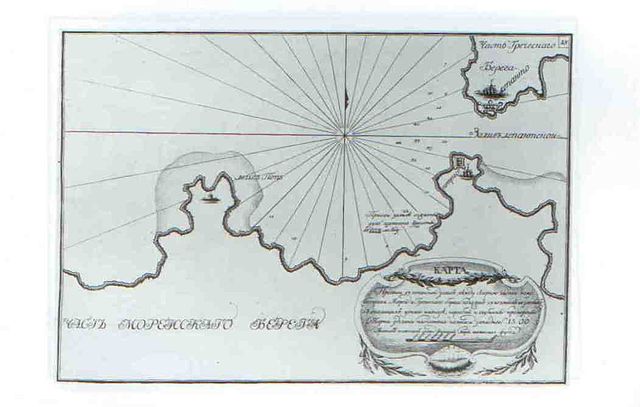
English: This is chart of the channel at the entrance to the Gulf of Corinth. Chart of the Channel leading into the gulf of Lepanto between the northern part of Moreas Peninsula and the Greek coast, drawn after bearings taken from the russian ships anchored therein, with depths measured. The charthas been complied with compass with western variation of 15.00. Scale in sazhens of 7-feet measure of English feet. Scale about 1:210000. The chart was made by russian navy during russo-turkish war 1769-1774. The place Battle of Patras is signed on the chart.
Русский: Это карта пролива между Патраским и Коринфским заливами. Карта пролива в Лепантской залив между северной частью полуострова Морея и Греческим берегом, положен с пеленгов взятых у стоявших у оного на якоре судов и промерены глубины. Глубины указаны в саженях семифутовой меры английского фута. Место Патрасского сражения 1772 года указано надписью. |
| Date | |
| Source | http://www.indrik.ru/catalogue/1997/Atlas_archipelagus.shtml |
| Author | Unknown author |
Licensing
[edit]
|
This work is in the public domain in its country of origin and other countries and areas where the copyright term is the author's life plus 100 years or fewer. | |
| This file has been identified as being free of known restrictions under copyright law, including all related and neighboring rights. | |
File history
Click on a date/time to view the file as it appeared at that time.
| Date/Time | Thumbnail | Dimensions | User | Comment | |
|---|---|---|---|---|---|
| current | 14:46, 2 December 2010 | | 1,051 × 669 (33 KB) | Kontiger (talk | contribs) | {{Information |Description={{en|1=This is chart of the channel at the entrance to the Gulf of Corinth. Chart of the Channel leading into the gulf of Lepanto between the northern part of Moreas Peninsula and the Greek coast, drawn after bearings taken from |
You cannot overwrite this file.
File usage on Commons
There are no pages that use this file.
File usage on other wikis
The following other wikis use this file:
- Usage on fr.wikipedia.org
- Usage on ru.wikipedia.org
- Usage on uk.wikipedia.org