File:Pelourinho de Murça - Portugal (4367643907).jpg
Original file (7,596 × 5,064 pixels, file size: 13.33 MB, MIME type: image/jpeg)
Captions
Captions
Summary
[edit].jpg&action=edit§ion=1)
| Description |
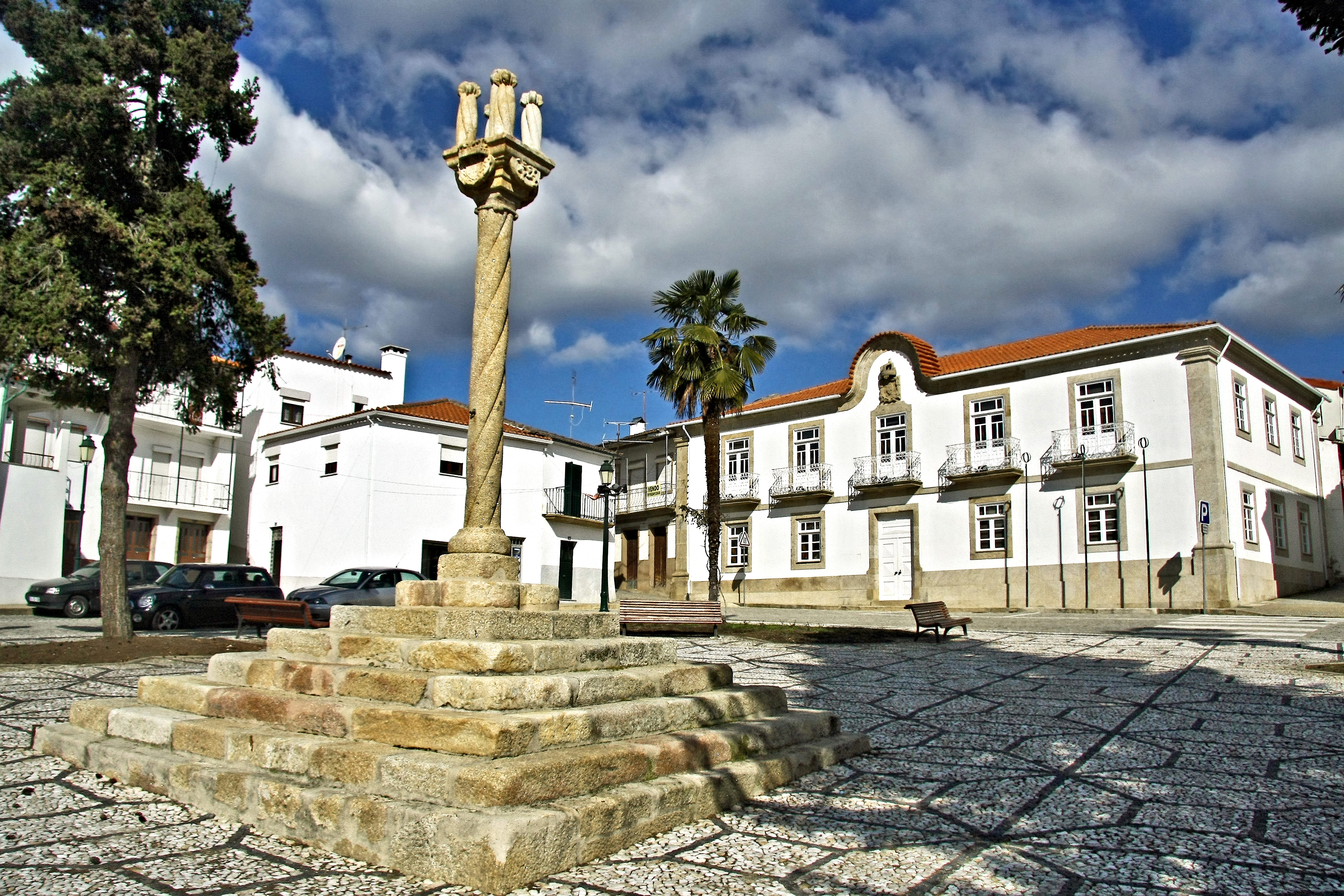
Pelourinho Classificado de monumento nacional por decreto de 16 de Junho de 1910, é um dos mais belos e bem conservados exemplares portugueses. Originários da Idade Média, os pelourinhos são a marca do Concelho, símbolos da liberdade e autonomia municipal, brasão do povo. Era junto deles que se executava a justiça municipal, muito mais isenta e branda que a dos "senhorios". Localizava se quase sempre no centro da população, geralmente em frente do Município para servirem de exemplo aos prevaricadores aquando da execução dos castigos. O actual pelourinho de Murça data do século XVI, não sendo este já o primitivo. A sua construção deve datar de 1512, data da renovação do Foral ao Concelho. Situa se no centro da praça principal da vila, mesmo em frente ao actual edifício da Câmara Municipal, da igreja matriz, e dos antigos paços do Concelho, outrora convento das freiras beneditinas. É enquadrado ainda por belos exemplares de casas senhoriais. Constitui um verdadeiro exemplar do estilo gótico. Todo feito em granito, assenta numa plataforma de sete degraus graníticos em forma piramidal, do meio dos quais se eleva uma elegante coluna em cordão. Encimada por um capitel que ostenta do lado sudoeste o brasão de D. Manuel e na face para sudeste as armas dos Guedes, donatários de Murça. Sobre este capitel assenta um triplo remate com cinco pequenas colunas idênticas à da base, em cordão. No meio da coluna, é visível ainda uma argola em ferro para prender os castigados. <a href="http://concelhos.dodouro.com/jornal/murca.asp" rel="nofollow">concelhos.dodouro.com/jornal/murca.asp</a> <a href="http://loc.alize.us/#/flickr:4367643907" rel="nofollow">See where this picture was taken.</a> <a href="https://www.flickr.com/groups/geotagging/discuss/72157594165549916/">[?]</a> |
| Date | |
| Source | Pelourinho de Murça - Portugal |
| Author | Vitor Oliveira from Torres Vedras, PORTUGAL |
| Camera location | | View this and other nearby images on: OpenStreetMap |
|---|
.jpg¶ms=041.408006_N_-007.453926_E_globe:Earth_type:camera_source:Flickr_&language=en)
Licensing
[edit].jpg&action=edit§ion=2)
- You are free:
- to share – to copy, distribute and transmit the work
- to remix – to adapt the work
- Under the following conditions:
- attribution – You must give appropriate credit, provide a link to the license, and indicate if changes were made. You may do so in any reasonable manner, but not in any way that suggests the licensor endorses you or your use.
- share alike – If you remix, transform, or build upon the material, you must distribute your contributions under the same or compatible license as the original.
| This image was originally posted to Flickr by Portuguese_eyes at https://flickr.com/photos/21446942@N00/4367643907 (archive). It was reviewed on 15 April 2019 by FlickreviewR 2 and was confirmed to be licensed under the terms of the cc-by-sa-2.0. |
File history
Click on a date/time to view the file as it appeared at that time.
| Date/Time | Thumbnail | Dimensions | User | Comment | |
|---|---|---|---|---|---|
| current | 05:04, 15 April 2019 | | 7,596 × 5,064 (13.33 MB) | Tm (talk | contribs) | Transferred from Flickr via #flickr2commons |
You cannot overwrite this file.
File usage on Commons
There are no pages that use this file.
File usage on other wikis
The following other wikis use this file:
- Usage on pt.wikipedia.org
.jpg&oldid=785606817)