File:Pelourinho de Pousaflores - Portugal (18739786303) (cropped).jpg
Original file (1,339 × 1,950 pixels, file size: 601 KB, MIME type: image/jpeg)
Captions
Captions
Summary
[edit]| Description |
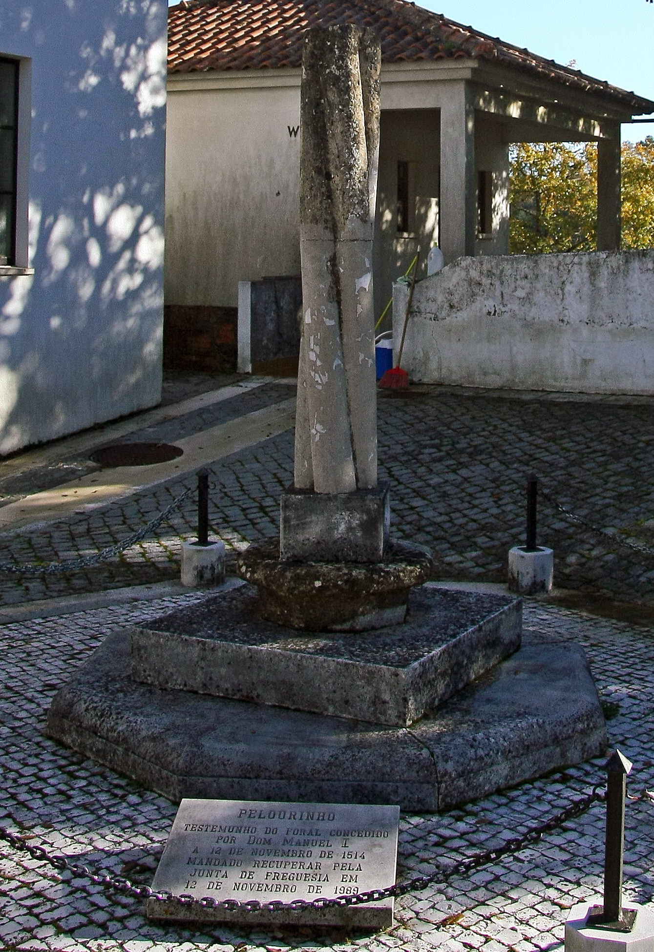
Pousaflores teve foral dado por D. Manuel, em 1514, na sequência do qual terá sido erguido o seu pelourinho. Este está infelizmente incompleto, embora ainda se erga na sua localização original, no largo da Matriz, onde igualmente se situa o edifício dos Paços do Concelho. Do monumento quinhentista resta a metade inferior, constando de soco, base, e um troço do fuste. No entanto, alguns destes elementos não serão originais, apresentando talhe moderno e pedra distinta. Assim acontece com a plataforma na qual se levanta o conjunto, oitavada e com o bordo superior boleado, e com o degrau que a encima, quadrado. Sobre este assenta um peça aparentemente quinhentista, que poderia ser a base original da coluna, igualmente oitavada, e com um largo parapeito boleado. Sustenta por sua vez um outro elemento quadrado, novamente de talhe moderno, de onde irrompe o fuste. Este é composto por quatro colunelos torsos, sem capitel ou remate. O conjunto está rodeado por pilaretes e protegido com uma corrente. É por vezes indicado que este pelourinho foi transformado em cruzeiro; no entanto, tal deve-se certamente à confusão com um cruzeiro vizinho, situado a poucos metros, no mesmo largo. SML <a href="http://www.patrimoniocultural.pt/pt/patrimonio/patrimonio-imovel/pesquisa-do-patrimonio/classificado-ou-em-vias-de-classificacao/geral/view/73863" rel="nofollow">www.patrimoniocultural.pt/pt/patrimonio/patrimonio-imovel...</a> |
| Date | |
| Source | Pelourinho de Pousaflores - Portugal |
| Author | Vitor Oliveira from Torres Vedras, PORTUGAL |
| Other versions |
.jpg)
_(cropped).jpg&action=edit§ion=1)
| Camera location | | View this and other nearby images on: OpenStreetMap |
|---|
_(cropped).jpg¶ms=039.867307_N_-008.395448_E_globe:Earth_type:camera_source:Flickr_&language=en)
Licensing
[edit]_(cropped).jpg&action=edit§ion=2)
- You are free:
- to share – to copy, distribute and transmit the work
- to remix – to adapt the work
- Under the following conditions:
- attribution – You must give appropriate credit, provide a link to the license, and indicate if changes were made. You may do so in any reasonable manner, but not in any way that suggests the licensor endorses you or your use.
- share alike – If you remix, transform, or build upon the material, you must distribute your contributions under the same or compatible license as the original.
File history
Click on a date/time to view the file as it appeared at that time.
| Date/Time | Thumbnail | Dimensions | User | Comment | |
|---|---|---|---|---|---|
| current | 16:57, 18 April 2022 | | 1,339 × 1,950 (601 KB) | Tm (talk | contribs) | File:Pelourinho de Pousaflores - Portugal (18739786303).jpg cropped 47 % horizontally, 49 % vertically using CropTool with precise mode. |
You cannot overwrite this file.
File usage on Commons
The following 2 pages use this file:
File usage on other wikis
The following other wikis use this file:
- Usage on es.wikipedia.org
- Usage on pt.wikipedia.org
- Usage on www.wikidata.org
_(cropped).jpg&oldid=785630622)