File:Pennsylvania Locator Map.PNG
跳转到导航
跳转到搜索
本预览的尺寸:800 × 460像素。 其他分辨率:320 × 184像素 | 640 × 368像素 | 964 × 554像素。
原始文件 (964 × 554像素,文件大小:13 KB,MIME类型:image/png)
说明
说明
添加一行文字以描述该文件所表现的内容
摘要
[编辑]
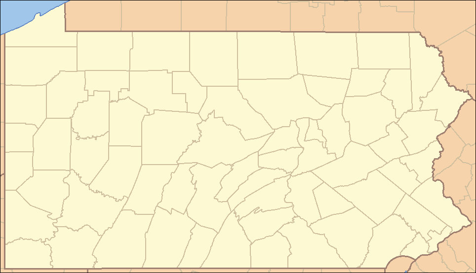
| 描述 | Locator Map of Pennsylvania, United States |
| 日期 | |
| 来源 | taken from US Census website [1] and modified by User:Ruhrfisch |
| 作者 | US Census, Ruhrfisch |
| 授权 (二次使用本文件) |
US Census / US Government work is public domain, myations licensed under the GNU Free Documentation License |
| 其他版本 |
Derivative works of this file: Location Caln Township.png four (with slightly different color schemes or smaller size), a vector version is at Image:Pennsylvania Locator Map.svg |
许可协议
[编辑]
I, Ruhrfisch,本作品著作权人,特此采用以下许可协议发表本作品:

|
已授权您依据自由软件基金会发行的无固定段落及封面封底文字(Invariant Sections, Front-Cover Texts, and Back-Cover Texts)的GNU自由文件许可协议1.2版或任意后续版本的条款,复制、传播和/或修改本文件。该协议的副本请见“GNU Free Documentation License”。 |
| 本文件采用知识共享署名-相同方式共享 3.0 未本地化版本许可协议授权。 | ||
| 署名: I, Ruhrfisch | ||
| ||
| 本许可协议标签作为GFDL许可协议更新的组成部分被添加至本文件。 |
本文件采用知识共享署名-相同方式共享 2.5 通用许可协议授权。
署名: I, Ruhrfisch
- 您可以自由地:
- 共享 – 复制、发行并传播本作品
- 修改 – 改编作品
- 惟须遵守下列条件:
- 署名 – 您必须对作品进行署名,提供授权条款的链接,并说明是否对原始内容进行了更改。您可以用任何合理的方式来署名,但不得以任何方式表明许可人认可您或您的使用。
- 相同方式共享 – 如果您再混合、转换或者基于本作品进行创作,您必须以与原先许可协议相同或相兼容的许可协议分发您贡献的作品。
您可以选择您需要的许可协议。
and
This image or file is a work of a United States Census Bureau employee, taken or made as part of that person's official duties. As a work of the U.S. federal government, the image is in the public domain.
|
 |
文件历史
点击某个日期/时间查看对应时刻的文件。
| 日期/时间 | 缩略图 | 大小 | 用户 | 备注 | |
|---|---|---|---|---|---|
| 当前 | 2009年3月22日 (日) 22:35 | | 964 × 554(13 KB) | Mahahahaneapneap(留言 | 贡献) | Compressed |
| 2007年9月5日 (三) 15:47 |  | 964 × 554(35 KB) | Ruhrfisch(留言 | 贡献) | Very minor fixes of a dozen or so incorrectly colored pixels in the body of the map (no border information pixels changed). All other information the same. | |
| 2007年4月25日 (三) 04:07 |  | 964 × 554(35 KB) | Ruhrfisch(留言 | 贡献) | {{Information| |Description= Locator Map of Pennsylvania, United States |Source= taken from US Census website [http://factfinder.census.gov/] and modified by User:Ruhrfisch |Date= April 2007 |Author= US Census, Ruhrfisch |Permission= US Census / US G | |
| 2007年4月23日 (一) 01:25 |  | 964 × 554(35 KB) | Ruhrfisch(留言 | 贡献) | {{Information| |Description= Locator Map of Pennsylvania, United States |Source= taken from US Census website [http://factfinder.census.gov/] and modified by User:Ruhrfisch |Date= APril 2007 |Author= US Census, Ruhrfisch |Permission= US Census / US G | |
| 2007年4月9日 (一) 05:07 |  | 962 × 552(35 KB) | Ruhrfisch(留言 | 贡献) | {{Information| |Description= Locator Map of Pennsylvania, United States |Source= taken from US Census website [http://factfinder.census.gov/] and modified by User:Ruhrfisch |Date= April 2007 |Author= US Census, Ruhrfisch |Permission= US Census / US G | |
| 2007年4月9日 (一) 04:50 |  | 327 × 193(8 KB) | Ruhrfisch(留言 | 贡献) | {{Information| |Description= Locator Map of Pennsylvania, United States |Source= taken from US Census website [http://factfinder.census.gov/] and modified by User:Ruhrfisch |Date= April 2007 |Author= US Census, Ruhrfisch |Permission= US Census / US G | |
| 2006年7月28日 (五) 12:59 |  | 288 × 168(26 KB) | Ruhrfisch(留言 | 贡献) | {{Information| |Description= Locator Map of Pennsylvania, United States |Source= taken from US Census website [http://factfinder.census.gov/] and modified by User:Ruhrfisch |Date= July 2006 |Author= US Census, Ruhrfisch |Permission= US Census / US Go |
您不可以覆盖此文件。
文件用途
以下页面使用本文件:
全域文件用途
以下其他wiki使用此文件:
- ceb.wikipedia.org上的用途
- de.wikipedia.org上的用途
- en.wikipedia.org上的用途
- List of Pennsylvania state parks
- User talk:Decumanus
- User talk:Bcasterline
- User:Ruhrfisch/Sandbox
- User talk:Choess/Archive4
- User talk:Tompw/archive2
- Template:State parks of Pennsylvania map
- User:Ruhrfisch/Pages
- User talk:Ruhrfisch/Archive4
- User talk:Qjuad/Archive 1
- User:IvoShandor/Recognitions
- User talk:VerruckteDan/Archive3
- User talk:Michaelas10/Archive/Archive 04
- User:Gerry D/archive2
- User talk:AceYYC/Archive2
- User talk:IvoShandor/Archive Apr 2007
- User talk:Underneath-it-All/Archive05
- User:Gerry D/archive3
- User talk:VerruckteDan/Archive4
- User:Ruhrfisch
- User talk:AndyZ/Archive 7
- User talk:Zntrip/Archive 1
- User:Sebwite/posmap
- User talk:Nationalparks/Archive 2
- es.wikipedia.org上的用途
- fa.wikipedia.org上的用途
- کربندیل، پنسیلوانیا
- چستر، پنسیلوانیا
- کوتسویل، پنسیلوانیا
- کونلسویل، پنسیلوانیا
- کاری، پنسیلوانیا
- ایری، پنسیلوانیا
- فارل، پنسیلوانیا
- هرمیتاژ، پنسیلوانیا
- مککیسپورت، پنسیلوانیا
- مادویل، پنسیلوانیا
- مانسن، پنسیلوانیا
- مونانگاهلا، پنسیلوانیا
- نیوکاسل، پنسیلوانیا
- شارون، پنسیلوانیا
- تیتوسویل، پنسیلوانیا
- انیونتاوون، پنسیلوانیا
- وارن، پنسیلوانیا
- واشینگتن، پنسیلوانیا
- الگو:Geobox locator Pennsylvania
- ناقوس آزادی
- چستربروک، پنسیلوانیا
查看此文件的更多全域用途。