File:Persia 600ad.jpg
元のファイル (1,098 × 623 ピクセル、ファイルサイズ: 644キロバイト、MIME タイプ: image/jpeg)
キャプション
キャプション
Rest

|
このhistorical map画像は、ベクターイメージである SVG ファイルとして再作成されるべきです。これにはいくつかの利点があります。詳しくはCommons:Media for cleanupを参照してください。この画像の SVG 形式がすでに利用可能である場合は、アップロードしてください。アップロード後、この画像にあるこのテンプレートを{{Vector version available|新しい画像ファイル名.svg}}テンプレートで置き換えてください。
|


概要[編集]
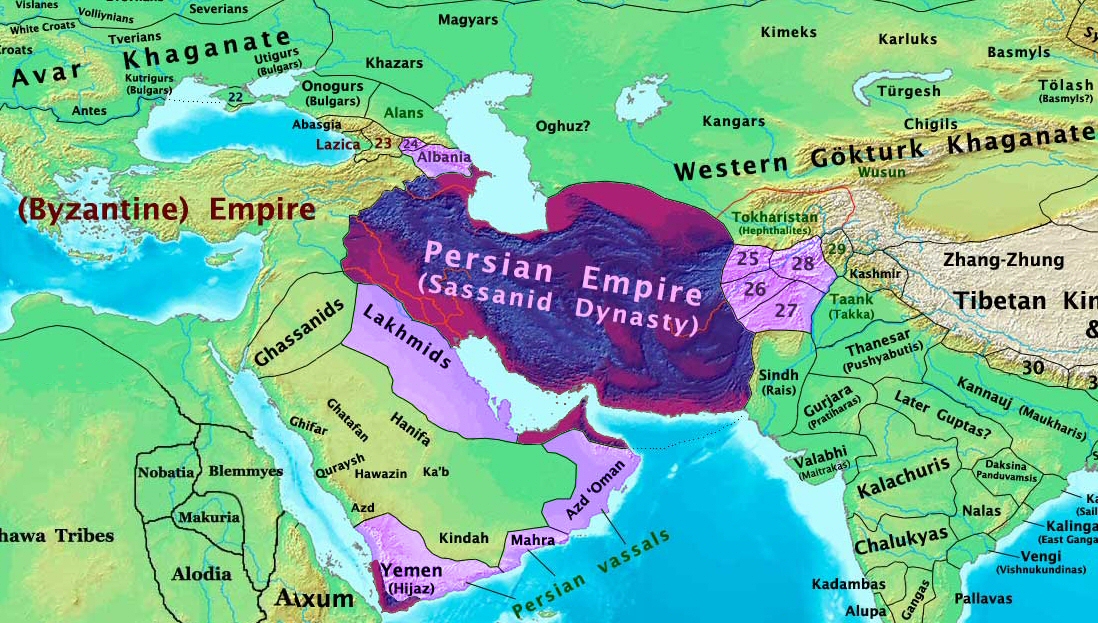
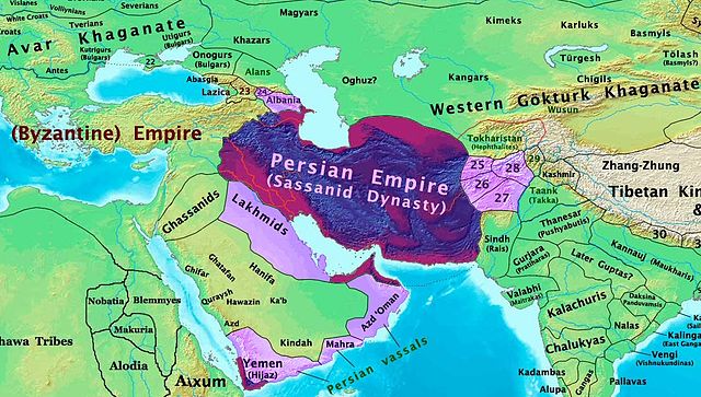
| 解説 | The Persian Sassanid Empire in 600 AD. |
| 日付 | |
| 原典 | 投稿者自身による著作物 |
| 作者 | Thomas Lessman (Contact!) |
| 許可 (ファイルの再利用) |
この作品の著作権者である私は、この作品を以下のライセンスで提供します。 このファイルはクリエイティブ・コモンズ 表示-継承 3.0 非移植ライセンスのもとに利用を許諾されています。
|
| その他のバージョン | see below |
Map Summary[編集]

Original Source URL: http://www.thomaslessman.com/History/images/East-Hem_600ad.jpg
This map is a zoomed-in version of Thomas Lessman's map of the
East-Hem_600ad.jpg (also available at www.WorldHistoryMaps.info).
The highlighted areas represent the Persian Sassanid Empire and its territories in the year 600 AD (before the Great Romano-Persian war).
Map Source References[編集]
Remember, sources often conflict with each other. This map is only as accurate as the information that is available to me. To report any errors or to help further this work, please click here, or email Thomas Lessman at talessman@yis.us
References for information contained in this map:
Other Maps by Thomas Lessman[編集]
| Maps of the eastern hemisphere showing history
Bold dates are available on Wikimedia or Wikipedia. | ||
| Primeval | ||
| Ancient
|
·| 600 BC | 550 BC | 527 BC | 500 BC |
400 BC | ·| 1 AD | 50 AD | 100 AD | 200 AD | 300 AD | | |
| Medieval |
·| 500 AD | 565 AD | 600 AD | 700 AD | | |
| Modern |
·| 1500 AD | · * For historical maps of the whole world, | |
Other Info[編集]
元のアップロードログ[編集]
- 2008-01-30 00:27 Talessman 1724×814×8 (267093 bytes) This image is a zoomed-in version of [http://en.wikipedia.org/wiki/Image:East-Hem_600ad.jpg Eastern Hemisphere in 600 AD]. The highlighted area is the Persian Sassanid Empire. [[Image:East-Hem_600ad.jpg|thumb|300px|left|Eastern Hemisphere in 600 AD.]] Author: T
ファイルの履歴
過去の版のファイルを表示するには、その版の日時をクリックしてください。
| 日付と時刻 | サムネイル | 寸法 | 利用者 | コメント | |
|---|---|---|---|---|---|
| 現在の版 | 2015年12月7日 (月) 19:44 | | 1,098 × 623 (644キロバイト) | B (トーク | 投稿記録) | Removed obnoxious label |
| 2008年8月21日 (木) 21:00 |  | 1,098 × 623 (813キロバイト) | Talessman (トーク | 投稿記録) | Updated version of the parent map. This new version features colored areas to highlight the Persian Empire and its vassal states. | |
| 2008年4月28日 (月) 17:25 |  | 1,724 × 814 (261キロバイト) | Producer (トーク | 投稿記録) | {{Information |Description={{en|This image is a zoomed-in version of [http://en.wikipedia.org/wiki/Image:East-Hem_600ad.jpg Eastern Hemisphere in 600 AD]. The highlighted area is the Sassanid Persian Empire. [[:en:Image:East-Hem_600ad.jpg|thumb|300px|lef |
このファイルは上書きできません。
ファイルの使用状況
以下の 6 ページがこのファイルを使用しています:
グローバルなファイル使用状況
以下に挙げる他のウィキがこの画像を使っています:
- ar.wikipedia.org での使用状況
- as.wikipedia.org での使用状況
- azb.wikipedia.org での使用状況
- bn.wikipedia.org での使用状況
- ca.wikipedia.org での使用状況
- cs.wikipedia.org での使用状況
- de.wikipedia.org での使用状況
- el.wikipedia.org での使用状況
- en.wikipedia.org での使用状況
- es.wikipedia.org での使用状況
- fa.wikipedia.org での使用状況
- fr.wikipedia.org での使用状況
- hi.wikipedia.org での使用状況
- hy.wikipedia.org での使用状況
- hyw.wikipedia.org での使用状況
- id.wikipedia.org での使用状況
- incubator.wikimedia.org での使用状況
- is.wikipedia.org での使用状況
- it.wikipedia.org での使用状況
- ja.wikipedia.org での使用状況
このファイルのグローバル使用状況を表示する。