File:Petit atlas pittoresque - 30. 7e arrondissement - Quartier Sainte-Avoye. No. 25 - David Rumsey.jpg
Aller à la navigation
Aller à la recherche

Taille de cet aperçu : 450 × 599 pixels. Autres résolutions : 180 × 240 pixels | 360 × 480 pixels | 577 × 768 pixels | 769 × 1 024 pixels | 1 539 × 2 048 pixels | 6 528 × 8 689 pixels.
Fichier d’origine (6 528 × 8 689 pixels, taille du fichier : 19,26 Mio, type MIME : image/jpeg)
Légendes
Légendes
Ajoutez en une ligne la description de ce que représente ce fichier
Description
[modifier]
| Titre |
Petit atlas pittoresque des quarante-huit quartiers de la ville de Paris; Par A. M. Perrot, Engenieur. A Paris, Chez E. Garnot, Libraire, Rue Pavee Saint-Andre des Arcs,No. 7. 1834. |
| Description |
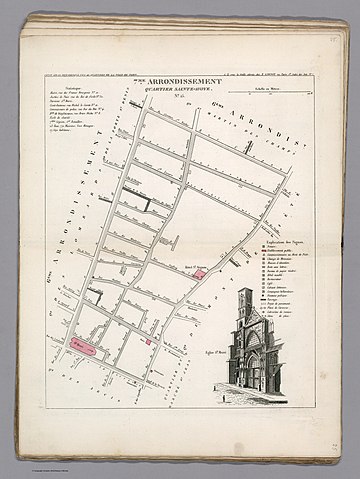
English: Engraved hand colored plan of 1 st. Borough, Faubroug du Roule, administrative district of Paris, with view of the Church of Saint -Philioppe du Roule. Shows roads, streets, monuments, city blocks, public buildings, etc. Includes explanation to symbols on the map and statistical table.
This is the first edition of an extremely uncommon atlas of the forty-eight districts of the city of Paris. Includes 50 color maps, a manuscript index and 48 pages of index to the neighborhoods and districts. Bound in green paper covers, with title "Petit atlas pittoresque des 48 quartiers de la ville de Paris, avec un tableau d'assemblage. Par A.-M. Perrot, Ingenieur." pasted on the cover. |
| Date | |
| Source | David Rumsey Historical Map Collection |
| Créé par |
Aristide-Michel Perrot |
| Données géotemporelles | |
| Lieu | Paris |
| Géoréférencement | Si c'est inapproprié, définissez warp_status = skip pour masquer. |
| Données bibliographiques | |
| Lieu de publication | Paris |
| Éditeur de publication |
E. Garnot |
| Données d'archives | |
| Collection | David Rumsey Historical Map Collection |
| Technique / matériaux | Atlas map |
Conditions d’utilisation
[modifier]
|
Cette œuvre est également dans le domaine public dans tous les pays pour lesquels le droit d’auteur a une durée de vie de 100 ans ou moins après la mort de l’auteur. | |
| Ce fichier a été identifié comme étant exempt de restrictions connues liées au droit d’auteur, y compris tous les droits connexes et voisins. | |
Historique du fichier
Cliquer sur une date et heure pour voir le fichier tel qu'il était à ce moment-là.
| Date et heure | Vignette | Dimensions | Utilisateur | Commentaire | |
|---|---|---|---|---|---|
| actuel | 18 janvier 2020 à 15:01 | | 6 528 × 8 689 (19,26 Mio) | Paris 16 (d | contributions) | User created page with UploadWizard |
Vous ne pouvez pas remplacer ce fichier.
Utilisations locales du fichier
Aucune page n’utilise ce fichier.
Utilisations du fichier sur d’autres wikis
Les autres wikis suivants utilisent ce fichier :
- Utilisation sur de.wikipedia.org
- Utilisation sur fr.wikipedia.org
Métadonnées
Catégories :
- Maps of Paris from the David Rumsey Historical Map Collection
- Petit atlas pittoresque des 48 quartiers de la ville de Paris, David Rumsey Historical Map Collection
- Paris former 7e arrondissement
- Old maps of Paris 4e arrondissement
- Street maps of Paris 4e arrondissement
- Église Saint-Merri
- Quartier Sainte-Avoye