File:Phewa Lake in Pokhara (15715573565).jpg
跳转到导航
跳转到搜索

本预览的尺寸:800 × 533像素。 其他分辨率:320 × 213像素 | 640 × 427像素 | 1,024 × 683像素 | 1,280 × 853像素 | 2,560 × 1,707像素 | 5,472 × 3,648像素。
原始文件 (5,472 × 3,648像素,文件大小:15.15 MB,MIME类型:image/jpeg)
说明
说明
添加一行文字以描述该文件所表现的内容
摘要
[编辑].jpg&action=edit§ion=1)
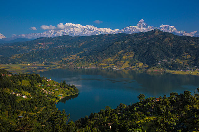
| 描述 | After a night in Kathmandu, our next stop towards Upper Mustang is Pokhara, just an half-hour flight from Katmandu with gorgeous views on the Himalayas all along (sit on the right of the aircraft). Pokhara is the second largest city of Nepal but, unlike the capital Kathmandu, it is quite loosely built up and still has much green space. The tourist district is along the north shore of Phewa lake. The Annapurna range on the north is only about 28 km away from the lake, and the lake is famous for the reflection of mount Machhapuchhre and other mountain peaks of the Annapurna and Dhaulagiri ranges on its surface. I still remember spending all the day there, back in the early eighties, just enjoying the fantastic view and feeling I was flying in the sky with the eagles after having picked the "magic mushroom omelet" on the breakfast menu Well this time has gone, but Pokhara is still one of the most enchanting place in the world and the new way to fly with the eagles is to have a tandem paraglider flight, a very popular activity these days. |
| 日期 | |
| 来源 | Phewa Lake in Pokhara |
| 作者 | Jean-Marie Hullot from France |
| 相机位置 | | 在以下服务上查看本图像和附近其他图像: OpenStreetMap |
|---|
.jpg¶ms=028.204061_N_0083.945102_E_globe:Earth_type:camera_source:Flickr_&language=zh-cn)
许可协议
[编辑].jpg&action=edit§ion=2)
| 这幅图片原始出处为Flickr的https://www.flickr.com/photos/32856635@N00/15715573565 ,作者为jmhullot 。经机器人FlickreviewR在2015年5月6日审查后确定为采用cc-by-2.0的协议授权使用。 |
文件历史
点击某个日期/时间查看对应时刻的文件。
| 日期/时间 | 缩略图 | 大小 | 用户 | 备注 | |
|---|---|---|---|---|---|
| 当前 | 2015年5月6日 (三) 20:26 | | 5,472 × 3,648(15.15 MB) | Bodhisattwa(留言 | 贡献) | Transferred from Flickr via Flickr2Commons |
您不可以覆盖此文件。
文件用途
没有页面使用本文件。
全域文件用途
以下其他wiki使用此文件:
- bcl.wikipedia.org上的用途
- bn.wikipedia.org上的用途
- cs.wikipedia.org上的用途
- dty.wikipedia.org上的用途
- en.wikipedia.org上的用途
- fa.wikipedia.org上的用途
- id.wikipedia.org上的用途
- lt.wikipedia.org上的用途
- ne.wikipedia.org上的用途
- pnb.wikipedia.org上的用途
- sat.wikipedia.org上的用途
- simple.wikipedia.org上的用途
- ta.wikipedia.org上的用途
- th.wikipedia.org上的用途
- ur.wikipedia.org上的用途
- zh.wikipedia.org上的用途
.jpg&oldid=888111822)