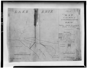
File:Photocopy of 1827 map of mouth of Cuyahoga River from Corps of Engineers files, Buffalo District. This is the earliest map of the Cleveland Harbor in the Corps' files. - HAER OHIO,18-CLEV,17-2.tif
跳转到导航
跳转到搜索

此TIF文件的JPG预览的大小:758 × 600像素。 其他分辨率:303 × 240像素 | 607 × 480像素 | 971 × 768像素 | 1,280 × 1,013像素 | 2,560 × 2,026像素 | 5,000 × 3,957像素。
原始文件 (5,000 × 3,957像素,文件大小:18.87 MB,MIME类型:image/tiff)
说明
说明
添加一行文字以描述该文件所表现的内容
摘要
[编辑]| Photocopy of 1827 map of mouth of Cuyahoga River from Corps of Engineers files, Buffalo District. This is the earliest map of the Cleveland Harbor in the Corps' files. - Cleveland Breakwater at Cleveland Harbor, Cleveland, Cuyahoga County, OH | ||||
|---|---|---|---|---|
| 标题 |
Photocopy of 1827 map of mouth of Cuyahoga River from Corps of Engineers files, Buffalo District. This is the earliest map of the Cleveland Harbor in the Corps' files. - Cleveland Breakwater at Cleveland Harbor, Cleveland, Cuyahoga County, OH |
|||
| 描绘地点 | Ohio; Cuyahoga County; Cleveland | |||
| 尺寸 | 4 x 5 in. | |||
| 现存地点 |
Library of Congress Prints and Photographs Division Washington, D.C. 20540 USA http://hdl.loc.gov/loc.pnp/pp.print |
|||
| 登录号 |
HAER OHIO,18-CLEV,17-2 |
|||
| 荣誉行 |
|
|||
| 来源 | https://www.loc.gov/pictures/item/oh0127.photos.125598p | |||
| 授权 (二次使用本文件) |
|
|||

文件历史
点击某个日期/时间查看对应时刻的文件。
| 日期/时间 | 缩略图 | 大小 | 用户 | 备注 | |
|---|---|---|---|---|---|
| 当前 | 2014年7月30日 (三) 11:26 |  | 5,000 × 3,957(18.87 MB) | Fæ(留言 | 贡献) | GWToolset: Creating mediafile for Fæ. HABS 30 July 2014 (2601:2900) |
您不可以覆盖此文件。
文件用途
全域文件用途
以下其他wiki使用此文件:
- zh.wikipedia.org上的用途