File:Piton Fournaise eruptions animated-fr.gif
跳转到导航
跳转到搜索

本预览的尺寸:514 × 600像素。 其他分辨率:206 × 240像素 | 411 × 480像素 | 720 × 840像素。
原始文件 (720 × 840像素,文件大小:678 KB,MIME类型:image/gif、循环、19帧、30秒)
说明
说明
添加一行文字以描述该文件所表现的内容
摘要
[编辑]| 描述 |
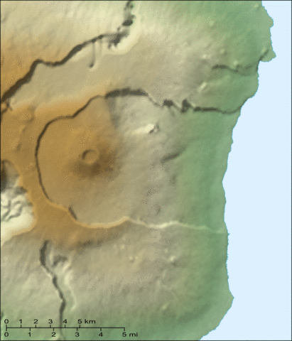
English: Animated map of the recent eruptions (1972 to 2000) of the Piton de la Fournaise shield volcano on the Réunion island.
Français : Carte animée des éruptions récentes (1972 à 2000) du volcan du Piton de la Fournaise sur l'île de la Réunion. |
||
| 日期 | |||
| 来源 |
Own work ; Topographic map : NASA Shuttle Radar Topography Mission (SRTM3 v.2) (public domain) edited with 3DEM from Visualization Software LLC ; Animation created with The GIMP ; References used : Maps from the Institut de Physique du Globe de Paris. |
||
| 作者 | Eric Gaba (Sting - fr:Sting) | ||
| 授权 (二次使用本文件) |
|
||
| 其他版本 |
|


许可协议
[编辑]
我,本作品著作权人,特此采用以下许可协议发表本作品:

|
已授权您依据自由软件基金会发行的无固定段落及封面封底文字(Invariant Sections, Front-Cover Texts, and Back-Cover Texts)的GNU自由文件许可协议1.2版或任意后续版本的条款,复制、传播和/或修改本文件。该协议的副本请见“GNU Free Documentation License”。 |
| 本文件采用知识共享署名-相同方式共享 3.0 未本地化版本许可协议授权。 | ||
| ||
| 本许可协议标签作为GFDL许可协议更新的组成部分被添加至本文件。 |
- 您可以自由地:
- 共享 – 复制、发行并传播本作品
- 修改 – 改编作品
- 惟须遵守下列条件:
- 署名 – 您必须对作品进行署名,提供授权条款的链接,并说明是否对原始内容进行了更改。您可以用任何合理的方式来署名,但不得以任何方式表明许可人认可您或您的使用。
- 相同方式共享 – 如果您再混合、转换或者基于本作品进行创作,您必须以与原先许可协议相同或相兼容的许可协议分发您贡献的作品。
您可以选择您需要的许可协议。
文件历史
点击某个日期/时间查看对应时刻的文件。
| 日期/时间 | 缩略图 | 大小 | 用户 | 备注 | |
|---|---|---|---|---|---|
| 当前 | 2007年6月13日 (三) 19:10 | | 720 × 840(678 KB) | Sting(留言 | 贡献) | Forgotten scale |
| 2007年6月13日 (三) 13:56 |  | 720 × 840(676 KB) | Sting(留言 | 贡献) | Lighter visual version (less crater names) | |
| 2007年6月12日 (二) 21:03 |  | 720 × 840(687 KB) | Sting(留言 | 贡献) | {{Information |Description=Animated map of the recent eruptions (1972 to 2000) of the ''Piton de la Fournaise'' shield volcano on the Réunion island. |Source=Own work ;<br/>Topographic map : [http://www2.jpl |
您不可以覆盖此文件。
文件用途
以下28个页面使用本文件:
- Wikimedia Conference Japan 2009/Commons写真展
- User:Miya/Introduction
- User:Sting/Gallery: Regional maps
- User:Sting/Profile
- Commons:Bu proje sayfasının diğer dil sürümleri
- Commons:Conhece os nossos ilustradores
- Commons:Conoce a nuestros ilustradores
- Commons:Descobreix els nostres il.lustradors
- Commons:Descobrètz nòstres illustrators
- Commons:Découvrez nos illustrateurs
- Commons:Meet our illustrators
- Commons:Meet our illustrators/People
- Commons:Poznaj naszych grafików
- Commons:Scopri i nostri illustratori
- Commons:Scummigghia ê nostri llustratura
- Commons:Unsere Illustratoren stellen sich vor
- Commons:Unseri Illustratore stelle sich vor
- Commons:Upoznajte naše ilustratore
- Commons:Çizerlerimizle tanışın
- Commons:Запознајте ги нашите илустратори
- Commons:Знайомтесь з нашими ілюстраторами
- Commons:Знакомьтесь с нашими иллюстраторами
- Commons:قابل رسامينا
- Commons:私達のイラストレータをご紹介します
- Commons:结识我们的插图师
- Commons:우리들의 삽화가를 만나보세요
- File:Piton Fournaise 1972-2000 eruptions-fr.svg
- File:Piton Fournaise topo map-fr.svg
全域文件用途
以下其他wiki使用此文件:
- ar.wikipedia.org上的用途
- de.wikivoyage.org上的用途
- en.wikipedia.org上的用途
- fr.wikipedia.org上的用途
- he.wikipedia.org上的用途
- pl.wikipedia.org上的用途
- sv.wikipedia.org上的用途
- zh.wikipedia.org上的用途