File:Plan-relief château Audenarde Palais des Beaux Arts Lille Dec 2018 Pierreazertyuiop.jpg
Jump to navigation
Jump to search

Size of this preview: 800 × 600 pixels. Other resolutions: 320 × 240 pixels | 640 × 480 pixels | 1,024 × 768 pixels | 1,280 × 960 pixels | 2,560 × 1,920 pixels | 4,608 × 3,456 pixels.
Original file (4,608 × 3,456 pixels, file size: 3.32 MB, MIME type: image/jpeg)
Captions
Captions
Add a one-line explanation of what this file represents
Summary
[edit]
| Description |
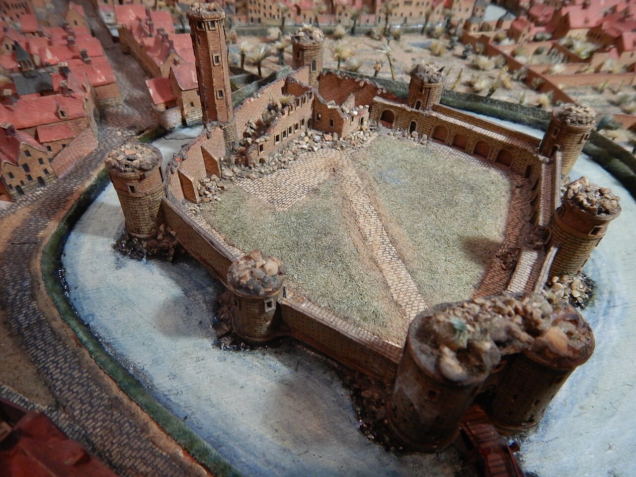
Français : Détail de l'un des plan-reliefs représentant la ville d'Audenarde, commandé par Louis XIV. Ce plan est conservé et exposé au Palais des Beaux-arts de Lille, et ici photographié en cours de restauration (le 19 décembre 2018).
Description : au premier et au deuxième plan : château fort médiéval, de plan polygonal, en ruine, situé dans la ville d’Audenarde et ceinturé de ses douves en eau. Troisième plan : maisons de briques avec toits en tuiles rouges et quelques jardins entourant l'eau qui protège le château. English: Detail of one of the Plans-reliefs representing the city of Oudenaarde, commissioned by Louis XIV. This plan is kept and exhibited at the Palais des Beaux-Arts in Lille, and here photographed during restoration (19 December 2018). Description: in the first and second plan : medieval castle in ruins, located in the city of Oudenaarde and surrounded by moats with water. Third floor: brick houses with red tiled roofs and some gardens surrounding the water that protects the castle |
| Date | |
| Source | Own work |
| Author | Pierreazertyuiop |
| Camera location | | View this and other nearby images on: OpenStreetMap |
|---|
Demande : découvrir l'emplacement de ce château (surement détruit) dans la ville d’Audenarde
Licensing
[edit]
I, the copyright holder of this work, hereby publish it under the following license:
This file is licensed under the Creative Commons Attribution-Share Alike 4.0 International license.
- You are free:
- to share – to copy, distribute and transmit the work
- to remix – to adapt the work
- Under the following conditions:
- attribution – You must give appropriate credit, provide a link to the license, and indicate if changes were made. You may do so in any reasonable manner, but not in any way that suggests the licensor endorses you or your use.
- share alike – If you remix, transform, or build upon the material, you must distribute your contributions under the same or compatible license as the original.
File history
Click on a date/time to view the file as it appeared at that time.
| Date/Time | Thumbnail | Dimensions | User | Comment | |
|---|---|---|---|---|---|
| current | 13:39, 22 December 2018 | | 4,608 × 3,456 (3.32 MB) | Embedded Data Bot (talk | contribs) | This file contains embedded data: After 3.3MiB (3478215 bytes, via Ending): Identified type: image/jpeg (JPEG image data, Exif standard: [TIFF image data, little-endian, direntries=1], baseline, precision 8, 640x480, frames 3) |
| 13:38, 22 December 2018 |  | 4,608 × 3,456 (3.68 MB) | Pierreazertyuiop (talk | contribs) | User created page with UploadWizard |
You cannot overwrite this file.
File usage on Commons
There are no pages that use this file.
File usage on other wikis
The following other wikis use this file:
- Usage on fr.wikipedia.org