File:Plan Chocz 1802 r..jpg
Jump to navigation
Jump to search

Size of this preview: 800 × 541 pixels. Other resolutions: 320 × 216 pixels | 640 × 433 pixels | 1,024 × 692 pixels | 1,280 × 865 pixels | 2,560 × 1,730 pixels | 4,345 × 2,937 pixels.
Original file (4,345 × 2,937 pixels, file size: 1.48 MB, MIME type: image/jpeg)
Captions
Captions
Add a one-line explanation of what this file represents
Summary[edit]
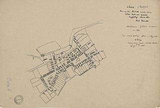
| Plan von den Streitorte zwischen den Gütern Chocz und Grodzisko
( |
||||||||||||||||||||||||
|---|---|---|---|---|---|---|---|---|---|---|---|---|---|---|---|---|---|---|---|---|---|---|---|---|
| Author |
|
|||||||||||||||||||||||
| Title |
Plan von den Streitorte zwischen den Gütern Chocz und Grodzisko |
|||||||||||||||||||||||
| Description |
plan (sporu miejsca między dobrami Chocz i Grodzisko) z roku 1802, a który to służył jako dowód w Sądzie Apelacyjnym Królestwa Polskiego w 1826 r. |
|||||||||||||||||||||||
| Medium | calque | |||||||||||||||||||||||
| Dimensions | height: 25 cm (9.8 in); width: 37 cm (14.5 in) | |||||||||||||||||||||||
| Collection |
|
|||||||||||||||||||||||
| Accession number |
53/1005/0/-/O.pl.m. 6 |
|||||||||||||||||||||||
| Notes | rękopis | |||||||||||||||||||||||
| Source/Photographer |
|
|||||||||||||||||||||||

._Ysbail.jpg)
Licensing[edit]
| This file is made available under the Creative Commons CC0 1.0 Universal Public Domain Dedication. | |
| The person who associated a work with this deed has dedicated the work to the public domain by waiving all of their rights to the work worldwide under copyright law, including all related and neighboring rights, to the extent allowed by law. You can copy, modify, distribute and perform the work, even for commercial purposes, all without asking permission.
|
File history
Click on a date/time to view the file as it appeared at that time.
| Date/Time | Thumbnail | Dimensions | User | Comment | |
|---|---|---|---|---|---|
| current | 08:17, 18 May 2015 | | 4,345 × 2,937 (1.48 MB) | Crashzeroo (talk | contribs) | VicuñaUploader 1.20 |
You cannot overwrite this file.
File usage on Commons
The following 2 pages use this file:
File usage on other wikis
The following other wikis use this file: