File:Plan de Paris en 1657.JPG

Fitxer original (5.500 × 4.605 píxels, mida del fitxer: 17,62 Mo, tipus MIME: image/jpeg)
Llegendes
Llegendes
Resum[modifica]
| Títol |
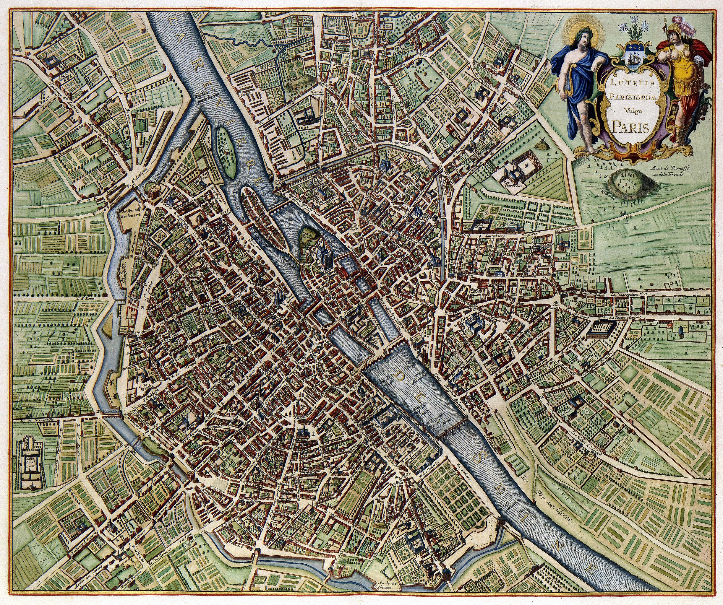
Lutetia Parisiorum vulgo Paris |
|||||||||||||||||||||||||
| Descripció | ||||||||||||||||||||||||||
| Data | published in 1657, the map depicts Paris as it appeared sometime after 1638 but before 1652 (see Talk page) | |||||||||||||||||||||||||
| Font | Geheugen van Nederland | |||||||||||||||||||||||||
| Creador |
|
|||||||||||||||||||||||||
| Geotemporal data | ||||||||||||||||||||||||||
| Bounding box |
|
|||||||||||||||||||||||||
| Georeferencing | ||||||||||||||||||||||||||
| Posició de l'objecte | | Aquesta i altres imatges properes a: OpenStreetMap |
|---|
Assessment[modifica]
|
Aquesta imatge va ser escollida imatge del dia el 21 May 2011. La seva descripció va ser la següent:
|
This digital media file - and/or the physical objects depicted on it - originates from the digital and/or physical collections of the Koninklijke Bibliotheek, national library of the Netherlands.
|
Llicència[modifica]
|
Això és una mera fotografia d'una obra d'art bidimensional en domini públic. L'obra d'art original és en domini públic pel següent motiu:
La posició oficial de la Fundació Wikimedia és que «les reproduccions fidels d'obres d'art bidimensionals de domini públic són en domini públic».
Per tant, aquesta reproducció fotogràfica també es considera en domini públic als Estats Units. En altres jurisdiccions la reutilització d'aquest contingut pot estar restringida; vegeu Reuse of PD-Art photographs per a més informació. | ||||
Historial del fitxer
Cliqueu una data/hora per veure el fitxer tal com era aleshores.
| Data/hora | Miniatura | Dimensions | Usuari/a | Comentari | |
|---|---|---|---|---|---|
| actual | 08:12, 18 feb 2010 | | 5.500 × 4.605 (17,62 Mo) | Thesupermat (discussió | contribucions) | {{Information |Description={{fr|1=Plan de Paris par Johannes Janssonius }} |Source=http://www.geheugenvannederland.nl/?/nl/items/KONB01:259/&st=Parijs&sc=(Parijs)+AND+(isPartOf+any+%22KONB01%22+) |Author=Johannes Janssonius |Date=1657 |Permission= |othe |
No podeu sobreescriure aquest fitxer.
Ús del fitxer
Les 52 pàgines següents utilitzen aquest fitxer:
- Chronologic old maps of Paris
- Maps of Paris
- Paris
- User:Paris 16/Paris
- User:Samsara/POTY 2011 overview
- User:Ö/Best/2011
- User talk:Paris 16/01
- Commons:Featured picture candidates/File:Plan de Paris en 1657.JPG
- Commons:Featured picture candidates/Log/January 2011
- Commons:Featured pictures/Non-photographic media/Maps
- Commons:Featured pictures/chronological/2011-A
- Commons:Koninklijke Bibliotheek/Reports
- Commons:Koninklijke Bibliotheek/Reports/most edited
- Commons:Koninklijke Bibliotheek/Reports/wikimedia usage
- Commons:Picture of the Year/2011/Galleries/2011-A
- Commons:Picture of the Year/2011/Galleries/A
- Commons:Picture of the Year/2011/Galleries/A/table
- Commons:Picture of the Year/2011/Galleries/ALL
- Commons:Picture of the Year/2011/Galleries/Diagrams
- Commons:Picture of the Year/2011/Galleries/Diagrams/Large
- Commons:Picture of the Year/2011/Galleries/Diagrams/Small
- Commons:Picture of the Year/2011/Galleries/Index/1
- Commons:Picture of the Year/2011/Galleries/Index/ALL
- Commons:Picture of the Year/2011/Galleries/Index/Diagrams
- Commons:Picture of the Year/2011/Galleries/JAN
- Commons:Picture of the Year/2011/Galleries/table
- Commons:Picture of the Year/2011/R1/Plan de Paris en 1657.JPG
- Commons:Picture of the Year/2011/Results/R1/ALL/table
- Commons:Picture of the Year/2011/Results/R1/Diagrams
- Commons:Picture of the Year/2011/Results/R1/Diagrams/table
- Commons:Potd/2011-05 (de)
- Commons:Potd/2011-05 (nl)
- Commons:Potd/2011-05 (pt)
- Commons talk:Picture of the Year/2011/Results/R1/ALL/table
- File:MontdeParnasse.jpg
- Template:Potd/2011-05
- Template:Potd/2011-05-21
- Template:Potd/2011-05-21 (cs)
- Template:Potd/2011-05-21 (de)
- Template:Potd/2011-05-21 (en)
- Template:Potd/2011-05-21 (es)
- Template:Potd/2011-05-21 (et)
- Template:Potd/2011-05-21 (fr)
- Template:Potd/2011-05-21 (ja)
- Template:Potd/2011-05-21 (nl)
- Template:Potd/2011-05-21 (pl)
- Template:Potd/2011-05-21 (ru)
- Template:Potd/2011-05-21 (sv)
- Template:Potd/2011-05-21 (uk)
- Template:Potd/2011-05-21 (zh-hans)
- Template:Potd/2011-05 (zh-hans)
- Category:Maps of Paris
Ús global del fitxer
Utilització d'aquest fitxer en altres wikis:
- Utilització a ba.wikipedia.org
- Utilització a be-tarask.wikipedia.org
- Utilització a bn.wikipedia.org
- Utilització a ca.wikipedia.org
- Utilització a crh.wikipedia.org
- Utilització a cv.wikipedia.org
- Utilització a da.wikipedia.org
- Utilització a el.wikipedia.org
- Utilització a en.wikipedia.org
- Utilització a fr.wikipedia.org
- Utilització a fy.wikipedia.org
- Utilització a hr.wikipedia.org
- Utilització a hu.wikipedia.org
- Utilització a ko.wikipedia.org
- Utilització a lbe.wikipedia.org
- Utilització a lb.wikipedia.org
- Utilització a mg.wikipedia.org
- Utilització a nl.wikipedia.org
- Utilització a os.wikipedia.org
- Utilització a pl.wikipedia.org
- Utilització a pt.wikipedia.org
- Utilització a ru.wikipedia.org
- Utilització a ru.wikinews.org
- Utilització a sah.wikipedia.org
- Utilització a su.wikipedia.org
- Utilització a sv.wikipedia.org
- Utilització a uk.wikipedia.org
- Utilització a ur.wikipedia.org
- Utilització a vi.wikipedia.org
- Utilització a xal.wikipedia.org
- Utilització a zh.wikipedia.org
Vegeu més usos globals d'aquest fitxer.