File:Plan de la cathedrale Amiens 1851 Archives nationales France.jpg

Original file (9,085 × 4,848 pixels, file size: 11.09 MB, MIME type: image/jpeg)
Captions
Captions
Summary[edit]
| Eugène Viollet-le-Duc: Q65008346
|
|||||||||||||||||||||
|---|---|---|---|---|---|---|---|---|---|---|---|---|---|---|---|---|---|---|---|---|---|
| Artist |
|
||||||||||||||||||||
| Title |
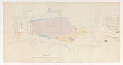
French: Démolition de maisons pour dégager les abords de la cathédrale d'Amiens label QS:Lfr,"Démolition de maisons pour dégager les abords de la cathédrale d'Amiens" |
||||||||||||||||||||
| Part of |
Sub-series F/19 of the Archives nationales |
||||||||||||||||||||
| Object type |
architectural drawing / drawing |
||||||||||||||||||||
| Description |
Démolition de maisons pour le dégagement de la cathédrale. Plan issu des dossiers de travaux de restauration des cathédrales (1802-1912), conservés aux Archives nationales (inventaire et autres documents numérisés consultables en ligne). |
||||||||||||||||||||
| Date |
1 July 1851 |
||||||||||||||||||||
| Medium |
paper and ink |
||||||||||||||||||||
| Dimensions |
height: 38.5 cm (15.1 in) dimensions QS:P2048,+38.5U174728 dimensions QS:P2049,+73U174728 |
||||||||||||||||||||
| Collection |
institution QS:P195,Q182542 |
||||||||||||||||||||
| Accession number |
CP/F/19/7602, Plan 1 (Archives nationales) |
||||||||||||||||||||
| Object location |
|
||||||||||||||||||||
| Place of creation | Amiens | ||||||||||||||||||||
| References |
http://www.siv.archives-nationales.culture.gouv.fr/siv/UD/FRAN_IR_054873/c-1ps2pppde9--1gikjm8ef1guh |
||||||||||||||||||||
| Source/Photographer |
institution QS:P195,Q182542 |
||||||||||||||||||||
| Permission (Reusing this file) |
|
||||||||||||||||||||
| Object location | 49° 53′ 40.5″ N, 2° 18′ 07.6″ E | View this and other nearby images on: OpenStreetMap |
|---|
File history
Click on a date/time to view the file as it appeared at that time.
| Date/Time | Thumbnail | Dimensions | User | Comment | |
|---|---|---|---|---|---|
| current | 14:36, 26 June 2018 |  | 9,085 × 4,848 (11.09 MB) | Archives nationales DJI (talk | contribs) | Téléversé avec ComeOn! 3.5.1 |
You cannot overwrite this file.
File usage on Commons
The following 2 pages use this file:
File usage on other wikis
The following other wikis use this file:
- Usage on www.wikidata.org
Metadata
This file contains additional information such as Exif metadata which may have been added by the digital camera, scanner, or software program used to create or digitize it. If the file has been modified from its original state, some details such as the timestamp may not fully reflect those of the original file. The timestamp is only as accurate as the clock in the camera, and it may be completely wrong.
| Short title | CP/F/19/7602 (Plan 1) |
|---|---|
| City shown | Pierrefitte-sur-Seine |
| Headline | Amiens : cathédrale Notre-Dame. - Démolition de maisons pour le dégagement de la cathédrale. [Par Eugène Viollet-le-Duc, architecte]. [1 juillet 1851] |
| Credit/Provider | Archives nationales (France) |
| Source | Puce & Plume |
| Copyright holder | Archives nationales (France) |
| Image title | Amiens : cathédrale Notre-Dame. - Démolition de maisons pour le dégagement de la cathédrale. [Par Eugène Viollet-le-Duc, architecte]. [1 juillet 1851] |
| Province or state shown | Pierrefitte-sur-Seine |
| Country shown | France |
| IIM version | 4 |
Structured data
image/jpeg
- Pages with complex technique templates
- CC-PD-Mark
- Author died more than 100 years ago public domain images
- Artworks with Wikidata item
- Artworks with accession number from Wikidata
- Artworks with known accession number
- Artworks with Wikidata item missing genre
- Artworks digital representation of 2D work
- Pages with object coordinates from SDC
- Files with coordinates missing SDC location of creation (49° N, 2° E)
- Pages with maps


