File:Plan de la retraite de Barren Hill en Pensilvanie - ou un détachement de deux mille deux cent hommes sous le G'al LaFayette étois entouré par l'Armée angloise sous les G'als Howe, Clinton et Grant le LOC 00557030.jpg
Jump to navigation
Jump to search

Size of this preview: 791 × 600 pixels. Other resolutions: 317 × 240 pixels | 633 × 480 pixels | 1,013 × 768 pixels | 1,280 × 971 pixels | 2,560 × 1,941 pixels | 6,140 × 4,656 pixels.
Original file (6,140 × 4,656 pixels, file size: 3.51 MB, MIME type: image/jpeg)
Captions
Captions
Add a one-line explanation of what this file represents
Summary
[edit]| Description |
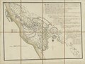
English: Covers Barren Hill and vicinity (Whitemarsh Twp., Montgomery Co., Pa.) with Chestnut Hill and Germantown. Relief shown by hachures. Place-names in English. Pen-and-ink, watercolors, wash, and lead pencil. Sectioned to 8 panels and mounted on cloth backing to fold to ca. 20 x 14 cm. Includes descriptive index of American, English, and Hessian military positions. Gift; Mr. and Mrs. H.F. Lenfest; Jan. 2000. Available also through the Library of Congress Web site as a raster image. Acquisitions control no.: 2000-49 |
||
| Title | Plan de la retraite de Barren Hill en Pensilvanie : ou un détachement de deux mille deux cent hommes sous le G'al LaFayette étois entouré par l'Armée angloise sous les G'als Howe, Clinton et Grant le 28 May 1778 | ||
| Shelf ID | G3824.B26S3 1778 .C3 | ||
| Date | |||
| Source | https://www.loc.gov/item/00557030/ | ||
| Author | Capitaine Du Chesnoy, Michel; Lafayette, Marie Joseph Paul Yves Roch Gilbert Du Motier | ||
| Permission (Reusing this file) |
|
||
| Other versions |
|
||
| Location | Chestnut Hill · Pennsylvania · Philadelphia · United States · Barren Hill Region · Germantown | ||
| Part of | France In America · Military Battles And Campaigns · Catalog · American Memory · Geography And Map Division · American Revolution And Its Era: Maps And Charts Of North America And The West Indies, 1750-1789 | ||
| Subject | Maps, Manuscript · Revolution · Chestnut Hill · Maps, Topographic · Defenses · Pennsylvania · Barren Hill Region (Pa.) · Philadelphia · Germantown (Philadelphia, Pa.) · United States · Maps · Early Works To 1800 · Chestnut Hill (Philadelphia, Pa.) · Barren Hill Region · Germantown · History |

Licensing
[edit]
|
This is a faithful photographic reproduction of a two-dimensional, public domain work of art. The work of art itself is in the public domain for the following reason:
The official position taken by the Wikimedia Foundation is that "faithful reproductions of two-dimensional public domain works of art are public domain".
This photographic reproduction is therefore also considered to be in the public domain in the United States. In other jurisdictions, re-use of this content may be restricted; see Reuse of PD-Art photographs for details. | ||||
File history
Click on a date/time to view the file as it appeared at that time.
| Date/Time | Thumbnail | Dimensions | User | Comment | |
|---|---|---|---|---|---|
| current | 11:43, 25 May 2018 | | 6,140 × 4,656 (3.51 MB) | Fæ (talk | contribs) | LOC Maps https://www.loc.gov/item/00557030/ #14883 |
You cannot overwrite this file.
File usage on Commons
The following page uses this file: