File:Plan du Fief et Seigneurie de l Isle Perrot.jpg
Original file (2,699 × 2,135 pixels, file size: 822 KB, MIME type: image/jpeg)
Captions
Captions
Summary
[edit]
| Description |
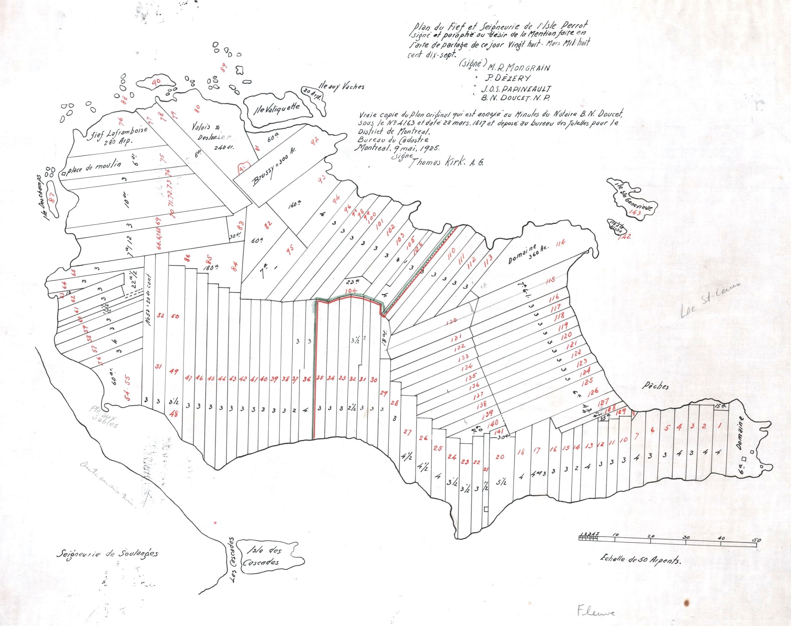
Plan du fief et seigneurie de l'Isle Perrot signé et parafé au désir de la mention faite l'acte de partage de ce jour vingt-huit mars mil huit cent dix sept / Thomas Kirk . - 50 arpents : 1 po . - Copié le 9 mai 1925, original créé le 28 mars 1817 - 1 plan(s) ; 42 x 62 cm Carte de la seigneurie de l'Île-Perrot au moment du partage en 1817. Cette mappe est annexée à l'acte de Doucet du 28 mars 1817. Le lecteur doit remarquer que certaines îles, qui faisaient partie de la seigneurie quand Talon la concéda à Perrot, n'y figurent pas. D'abord l'Ile Saint-Gilles, (aujourd'hui Girwood island), qui se trouve tout près du fief Senneville et qui fut annexée à ce dernier fief (en raison de sa proximité) vers 1705‑6. Les Iles De La Paix également n'apparaissent pas sur la mappe puisque comme nous l'avons vu, elles n'étaient pas inclues dans la vente de la seigneurie par LeMoyne à Desruisseaux en 1703. Les Iles De La Paix furent vendues avec la seigneurie de Châteauguay par les mêmes LeMoyne |
| Date | original créé le 28 mars 1817 - copié le 9 mai 1925 |
| Source | images.banq.qc.ca - pistard.banq.qc.ca |
| Author | Anonymous |
Licensing
[edit]
This work is in the public domain in the United States because it meets three requirements:
For background information, see the explanations on Non-U.S. copyrights.
Note: This tag should not be used for sound recordings. |
This Canadian work is in the public domain in Canada because its copyright has expired due to one of the following:
it was not subject to Crown copyright, and
|
 |
File history
Click on a date/time to view the file as it appeared at that time.
| Date/Time | Thumbnail | Dimensions | User | Comment | |
|---|---|---|---|---|---|
| current | 22:50, 4 June 2015 | | 2,699 × 2,135 (822 KB) | Jeangagnon (talk | contribs) | crop |
| 22:45, 4 June 2015 |  | 3,500 × 2,325 (1,003 KB) | Jeangagnon (talk | contribs) | == {{int:filedesc}} == {{Information |Description=Carte de la seigneurie de l'Île-Perrot au moment du partage en 1817. Cette mappe est annexée à l'acte de Doucet du 28 mars 1817. Le lecteur doit remarquer que certaines îles, qui faisaient partie de... |
You cannot overwrite this file.
File usage on Commons
There are no pages that use this file.
File usage on other wikis
The following other wikis use this file:
- Usage on fr.wikipedia.org