File:Plan ft st philip.jpg
ナビゲーションに移動
検索に移動
このプレビューのサイズ: 530 × 600 ピクセル。 その他の解像度: 212 × 240 ピクセル | 600 × 679 ピクセル。
元のファイル (600 × 679 ピクセル、ファイルサイズ: 75キロバイト、MIME タイプ: image/jpeg)
キャプション
キャプション
このファイルの内容を1行で記述してください
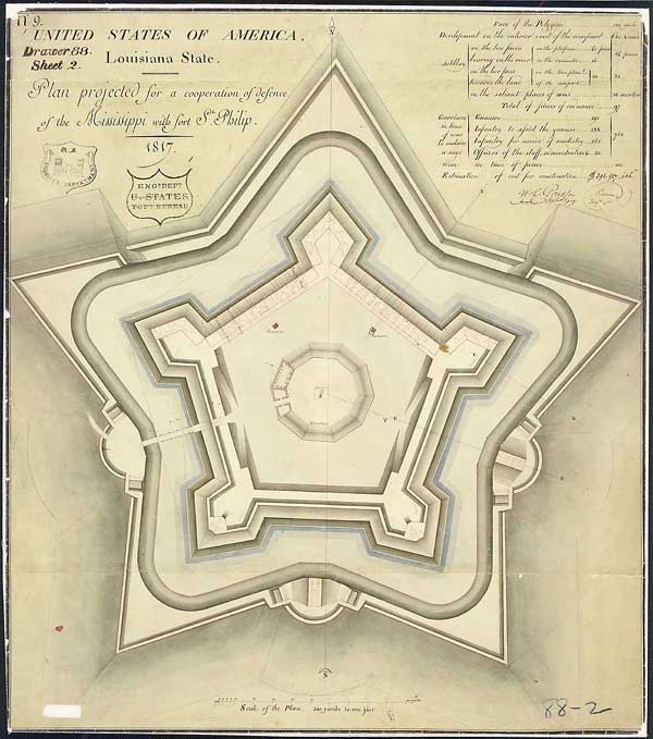
"Plan Projected for a Cooperation of Defense of the Mississippi with Ft. St. Philip" Drawn by cartographer and draftsman Guillaume Tell Poussin, 1817 Ink and wash on paper
This planned fort, to work in cooperation with the existing colonial era Fort St. Phillip on the East Bank of the Mississippi River in what is now Plaquemines Parish, Louisiana, was constructed starting in 1822 on the West Bank of the Mississippi, and named Fort Jackson.
Image previously uploaded to en:Wikipedia 12:59, 17 September 2005 by en:User:Darwinek
このファイルは、アメリカ合衆国の連邦政府と雇用関係にある公務員がその職務上作成したアメリカ合衆国政府の著作物であり、アメリカ合衆国の著作権法上パブリックドメインに属します (17 U.S.C. §105)。
注意:このライセンスは、アメリカ合衆国政府の著作物についてのみ効力を有します。アメリカ合衆国の各州、郡、その他の地方自治体が作成した著作物に対しては適用できません。
|
 | |
| このファイルは著作権法の既知の制約(隣接権や関連する権利を含む)から自由であると特定されています。 | ||
ファイルの履歴
過去の版のファイルを表示するには、その版の日時をクリックしてください。
| 日付と時刻 | サムネイル | 寸法 | 利用者 | コメント | |
|---|---|---|---|---|---|
| 現在の版 | 2007年3月28日 (水) 23:48 | | 600 × 679 (75キロバイト) | Infrogmation (トーク | 投稿記録) | "Plan Projected for a Cooperation of Defense of the Mississippi with Ft. St. Philip" Drawn by cartographer and draftsman Guillaume Tell Poussin, 1817 Ink and wash on paper This planned fort, to work in cooperation with the existing colonial era Fort S |
このファイルは上書きできません。
ファイルの使用状況
このファイルを使用しているページはありません。
グローバルなファイル使用状況
以下に挙げる他のウィキがこの画像を使っています:
- de.wikipedia.org での使用状況
- en.wikipedia.org での使用状況
- it.wikipedia.org での使用状況
- ja.wikipedia.org での使用状況
- nl.wikipedia.org での使用状況
- ru.wikipedia.org での使用状況