File:Plan of Fort Rosalia. LOC 2003627088.jpg
Jump to navigation
Jump to search

Size of this preview: 510 × 599 pixels. Other resolutions: 204 × 240 pixels | 408 × 480 pixels | 654 × 768 pixels | 872 × 1,024 pixels | 1,927 × 2,264 pixels.
Original file (1,927 × 2,264 pixels, file size: 967 KB, MIME type: image/jpeg)
Captions
Captions
Add a one-line explanation of what this file represents
Summary
[edit]| Description |
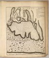
English: Oriented with North to the right. Available also through the Library of Congress web site as a raster image. |
||
| Title | Plan of Fort Rosalia. | ||
| Shelf ID | F352 .P68 G3984.N2:2F6 | ||
| Date | |||
| Source | https://www.loc.gov/item/2003627088/ | ||
| Author | Pittman, Philip | ||
| Permission (Reusing this file) |
|
||
| Other versions |
|
||
| Location | United States · Mississippi · Fort Panmure | ||
| Part of | Military Battles And Campaigns · American Memory · Catalog · Geography And Map Division | ||
| Subject | Mississippi · Fort Panmure · United States · Maps · Early Works To 1800 · Fort Panmure (Miss.) |

Licensing
[edit]
|
This is a faithful photographic reproduction of a two-dimensional, public domain work of art. The work of art itself is in the public domain for the following reason:
The official position taken by the Wikimedia Foundation is that "faithful reproductions of two-dimensional public domain works of art are public domain".
This photographic reproduction is therefore also considered to be in the public domain in the United States. In other jurisdictions, re-use of this content may be restricted; see Reuse of PD-Art photographs for details. | ||||
File history
Click on a date/time to view the file as it appeared at that time.
| Date/Time | Thumbnail | Dimensions | User | Comment | |
|---|---|---|---|---|---|
| current | 19:01, 2 June 2018 | | 1,927 × 2,264 (967 KB) | Fæ (talk | contribs) | LOC Maps https://www.loc.gov/item/2003627088/ #2669 |
You cannot overwrite this file.
File usage on Commons
The following page uses this file: