File:Plano de París.jpg
Jump to navigation
Jump to search

Size of this preview: 800 × 527 pixels. Other resolutions: 320 × 211 pixels | 640 × 422 pixels | 1,024 × 674 pixels | 1,280 × 843 pixels.
Original file (1,280 × 843 pixels, file size: 743 KB, MIME type: image/jpeg)
Captions
Captions
Add a one-line explanation of what this file represents
Summary
[edit]| Description |
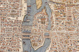
English: Plan of Paris by Truschet et Hoyau, scale ca. 1:4,500 (94 x 120 cm). Seefeld (Zurich) published this 1980 facsimile of the original map, also known as the plan de Bâle (Basel plan). Boutier gives a date of c. 1553 and estimates a scale of c. 1:7,000. The original is in color and was engraved on wood, 8 plates, 96 x 133 cm assembled.
Français : Le plan de Paris par Truschet et Hoyau, La ville, cité, université de Paris, échelle 1:4 500 environ (facsimile Seefeld, Zürich 1980). |
| References |
|
| Date | circa 1550 |
| Source | NL, Universiteitsbibliotheek Vrije Universiteit, LL.06979gk: 130/od/1550; http://imagebase.ubvu.vu.nl/getobj.php?ppn=330025988 |
| Creator |
Olivier Truschet, engraver (?) Germain Hoyau, designer (?) |
| Georeferencing | If inappropriate please set warp_status = skip to hide. |
| Other versions |
|

Licensing
[edit]
|
This work is in the public domain in its country of origin and other countries and areas where the copyright term is the author's life plus 100 years or fewer. | |
| This file has been identified as being free of known restrictions under copyright law, including all related and neighboring rights. | |
File history
Click on a date/time to view the file as it appeared at that time.
| Date/Time | Thumbnail | Dimensions | User | Comment | |
|---|---|---|---|---|---|
| current | 20:40, 10 April 2023 | | 1,280 × 843 (743 KB) | Althair (talk | contribs) | Uploaded own work with UploadWizard |
You cannot overwrite this file.
File usage on Commons
There are no pages that use this file.