File:Plano de la costa de Puerto Velo que comprehende desde el Canal de Juan Gallegos hasta la Ysla de Naranjos LOC 90680562.jpg
Jump to navigation
Jump to search

Size of this preview: 769 × 600 pixels. Other resolutions: 308 × 240 pixels | 616 × 480 pixels | 985 × 768 pixels | 1,280 × 998 pixels | 2,560 × 1,997 pixels | 5,852 × 4,564 pixels.
Original file (5,852 × 4,564 pixels, file size: 2.02 MB, MIME type: image/jpeg)
Captions
Captions
Add a one-line explanation of what this file represents
Summary
[edit]| Description |
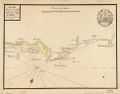
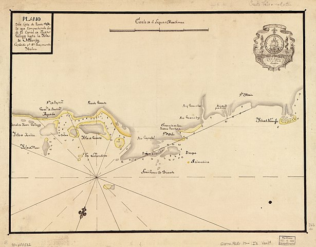
English: Shows coast of Portobelo region. Depths shown by soundings. Oriented with north toward the lower left. Watermarks: IV; and, fleur-de-lis over the characters VDL. Pen-and-ink and yellow watercolor. Mounted on cloth backing. LC Luso-Hispanic World, 674 Available also through the Library of Congress Web site as a raster image. Maggs number annotated in pencil in lower right margin: 262. Vault |
||
| Title | Plano de la costa de Puerto Velo que comprehende desde el Canal de Juan Gallegos hasta la Ysla de Naranjos | ||
| Shelf ID | G4874.P6A1 17-- .I2 | ||
| Date | |||
| Source | https://www.loc.gov/item/90680562/ | ||
| Author | Ibañez, Raymundo | ||
| Permission (Reusing this file) |
|
||
| Other versions |
|
||
| Location | Portobelo Region · Panama | ||
| Part of | American Memory · Catalog · Geography And Map Division · Cultural Landscapes | ||
| Subject | Maps, Manuscript · Panama · Coasts · Portobelo Region (Panama) · Portobelo Region · Early Works To 1800 |

Licensing
[edit]
|
This is a faithful photographic reproduction of a two-dimensional, public domain work of art. The work of art itself is in the public domain for the following reason:
The official position taken by the Wikimedia Foundation is that "faithful reproductions of two-dimensional public domain works of art are public domain".
This photographic reproduction is therefore also considered to be in the public domain in the United States. In other jurisdictions, re-use of this content may be restricted; see Reuse of PD-Art photographs for details. | ||||
File history
Click on a date/time to view the file as it appeared at that time.
| Date/Time | Thumbnail | Dimensions | User | Comment | |
|---|---|---|---|---|---|
| current | 16:13, 23 May 2018 | | 5,852 × 4,564 (2.02 MB) | Fæ (talk | contribs) | LOC Maps https://www.loc.gov/item/90680562/ #103 |
You cannot overwrite this file.
File usage on Commons
The following page uses this file: