File:Plano del puerto de Cartagena de Yndias situado en la latitud N. 10 gros 30 minutos y en la longd. 298. gros y 15 ms. segn. el meridiano de Thenerife LOC 90682781.jpg
Jump to navigation
Jump to search

Size of this preview: 730 × 600 pixels. Other resolutions: 292 × 240 pixels | 585 × 480 pixels | 935 × 768 pixels | 1,247 × 1,024 pixels | 2,494 × 2,048 pixels | 5,770 × 4,739 pixels.
Original file (5,770 × 4,739 pixels, file size: 3.25 MB, MIME type: image/jpeg)
Captions
Captions
Add a one-line explanation of what this file represents
Summary
[edit]| Description |
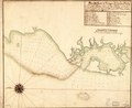
English: Shows coast of Colombia in the region of Cartagena. Relief shown pictorially. Depths shown by soundings. Prime meridian: Tenerife. Oriented with north toward the upper left. Pen-and-ink and watercolor. Mounted on cloth backing. LC Luso-Hispanic World, 281 Available also through the Library of Congress Web site as a raster image. Indexed. Signature in black ink in lower right corner: Juan Cayno. Maggs number annotated in pencil in lower right corner: 38. Vault |
||
| Title | Plano del puerto de Cartagena de Yndias situado en la latitud N. 10 gros 30 minutos y en la longd. 298. gros y 15 ms. segn. el meridiano de Thenerife | ||
| Shelf ID | G5294.C3A1 17-- .D4 | ||
| Date | |||
| Source | https://www.loc.gov/item/90682781/ | ||
| Author | Delgado Y Gonzales, Gerónimo | ||
| Permission (Reusing this file) |
|
||
| Other versions |
|
||
| Location | Cartagena Region · Atlantic Coast · Colombia | ||
| Part of | American Memory · Catalog · Geography And Map Division · Cultural Landscapes | ||
| Subject | Maps, Manuscript · Atlantic Coast (Colombia) · Coasts · Cartagena Region (Colombia) · Maps · Early Works To 1800 · Colombia · Atlantic Coast · Cartagena Region · Manuscript Maps |

Licensing
[edit]
|
This is a faithful photographic reproduction of a two-dimensional, public domain work of art. The work of art itself is in the public domain for the following reason:
The official position taken by the Wikimedia Foundation is that "faithful reproductions of two-dimensional public domain works of art are public domain".
This photographic reproduction is therefore also considered to be in the public domain in the United States. In other jurisdictions, re-use of this content may be restricted; see Reuse of PD-Art photographs for details. | ||||
File history
Click on a date/time to view the file as it appeared at that time.
| Date/Time | Thumbnail | Dimensions | User | Comment | |
|---|---|---|---|---|---|
| current | 00:23, 30 May 2018 | | 5,770 × 4,739 (3.25 MB) | Fæ (talk | contribs) | LOC Maps https://www.loc.gov/item/90682781/ #15282 |
You cannot overwrite this file.
File usage on Commons
The following page uses this file: