File:Plat book of Greene County, Missouri - compiled from county records and actual surveys LOC 2007626859-10.jpg
Jump to navigation
Jump to search

Size of this preview: 474 × 599 pixels. Other resolutions: 190 × 240 pixels | 380 × 480 pixels | 608 × 768 pixels | 810 × 1,024 pixels | 2,275 × 2,874 pixels.
Original file (2,275 × 2,874 pixels, file size: 955 KB, MIME type: image/jpeg)
Captions
Captions
Add a one-line explanation of what this file represents
Summary
[edit]| Description |
English: Available also through the Library of Congress Web site as a raster image. Includes indexes and maps of Missouri, the United States, and the world. LC copy imperfect: P. 2-35 separated from binding. Vendor: Religious Books on the Net Acquisitions control no. 2006-119 |
||
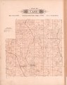
| Title | Plat book of Greene County, Missouri : compiled from county records and actual surveys | ||
| Shelf ID | G1438.G7 M5 1904 | ||
| Parent | https://www.loc.gov/resource/g4163gm.gla00018/ | ||
| Sheet title | Cass | ||
| Date | |||
| Source | https://www.loc.gov/item/2007626859/ | ||
| Author | Missouri Publishing Co.; Balliet & Volk | ||
| Permission (Reusing this file) |
|
||
| Other versions |
|
||
| Location | United States · Greene County · Missouri | ||
| Part of | American Memory · Catalog · County Landownership Maps · Geography And Map Division · Cultural Landscapes | ||
| Subject | Greene County · Greene County (Mo.) · Directories · United States · Maps · Missouri · Real Property · Landowners |

Licensing
[edit]
|
This is a faithful photographic reproduction of a two-dimensional, public domain work of art. The work of art itself is in the public domain for the following reason:
The official position taken by the Wikimedia Foundation is that "faithful reproductions of two-dimensional public domain works of art are public domain".
This photographic reproduction is therefore also considered to be in the public domain in the United States. In other jurisdictions, re-use of this content may be restricted; see Reuse of PD-Art photographs for details. | ||||
File history
Click on a date/time to view the file as it appeared at that time.
| Date/Time | Thumbnail | Dimensions | User | Comment | |
|---|---|---|---|---|---|
| current | 08:57, 13 June 2018 | | 2,275 × 2,874 (955 KB) | Fæ (talk | contribs) | LOC Maps multisheet https://www.loc.gov/item/2007626859/ sheet 10 of 40 #15762 |
You cannot overwrite this file.
File usage on Commons
The following page uses this file: