File:Point 7762 ft 28115.JPG
Jump to navigation
Jump to search

Size of this preview: 800 × 600 pixels. Other resolutions: 320 × 240 pixels | 640 × 480 pixels | 1,024 × 768 pixels | 1,280 × 960 pixels | 2,560 × 1,920 pixels.
Original file (2,560 × 1,920 pixels, file size: 1.43 MB, MIME type: image/jpeg)
Captions
Captions
Add a one-line explanation of what this file represents
Summary[edit]
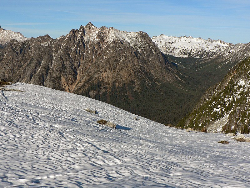
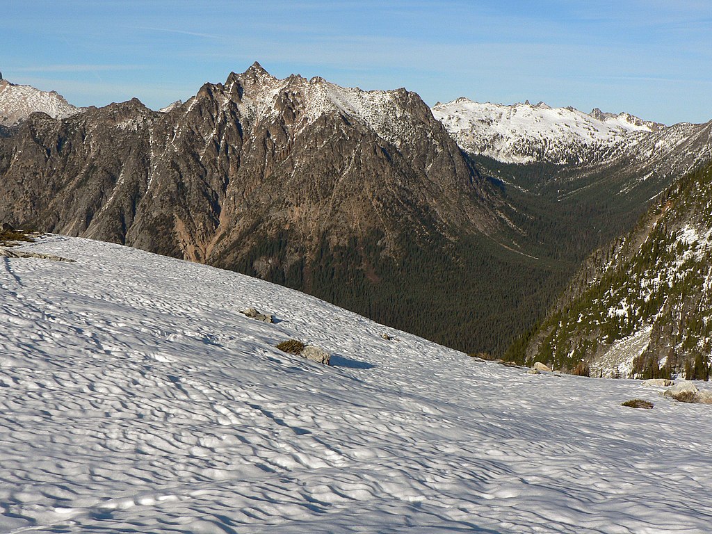
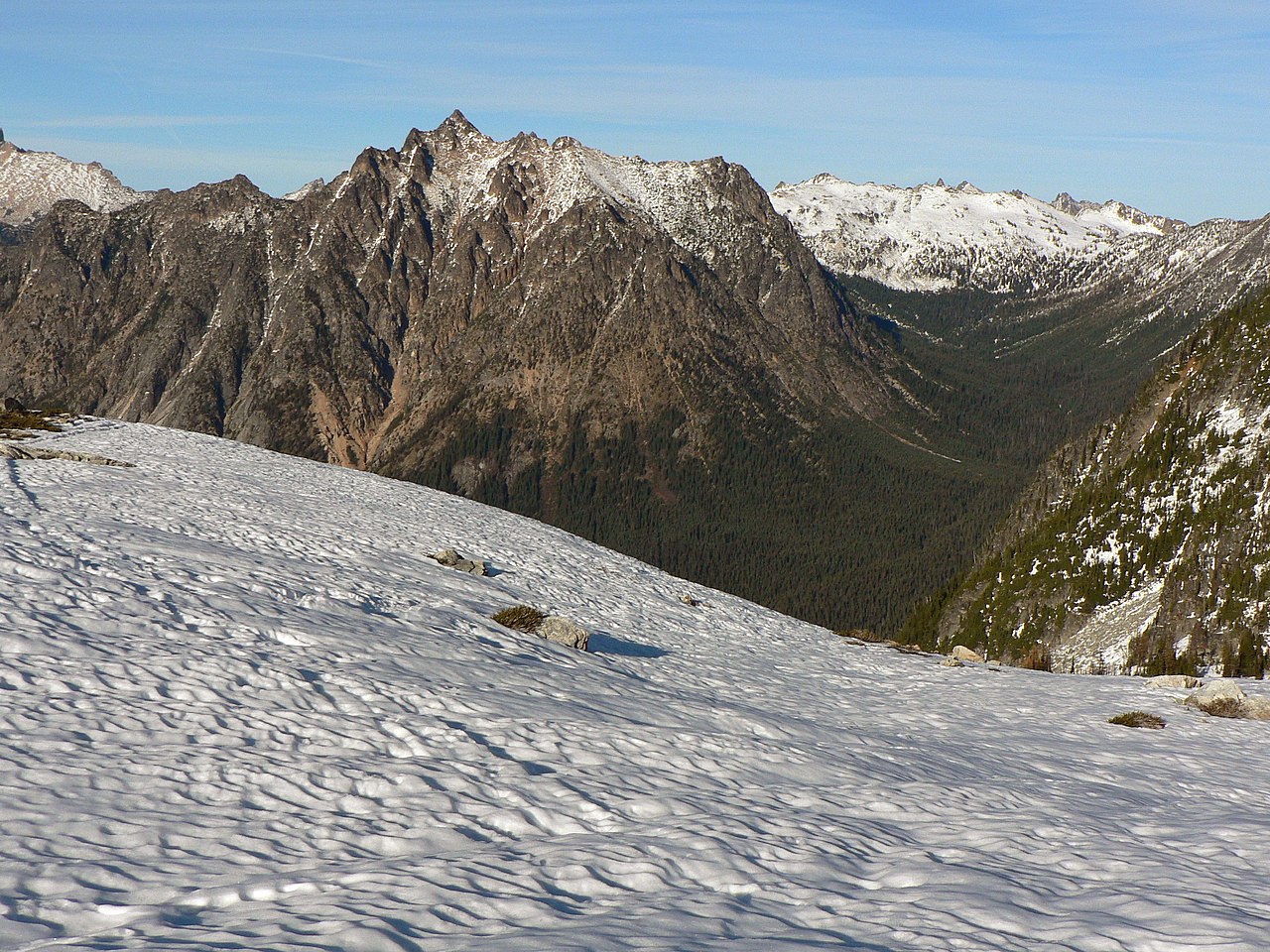
Point 7762 ft
| Description |
English: Point 7762 ft (left center), Porcupine Creek Valley (right, the route of the Pacific Crest Trail) with Point 7552 feet behind. |
| Date | 23 October 2007, 16:08:12 −07:00 |
| Source | Own work |
| Author | Walter Siegmund (talk) |
| Camera location | | View this and other nearby images on: OpenStreetMap |
|---|
- Location Datum: WGS84
- Viewpoint location: Lake Ann - Maple Pass Trail # 740 North Cascades National Park
- Viewpoint elevation: 2027 meter (6651 ft)
- View direction: North-northeast
- Camera: Panasonic DMC-FZ5
- Exposure Time: 1/1000
- F Number: f/5.0
- Focal Length: 9.8
- Focal Length In 35mm Film: 59
- ISO Speed Rating: 80
©2007 Walter Siegmund
Licensing[edit]
I, the copyright holder of this work, hereby publish it under the following licenses:

|
Permission is granted to copy, distribute and/or modify this document under the terms of the GNU Free Documentation License, Version 1.2 or any later version published by the Free Software Foundation; with no Invariant Sections, no Front-Cover Texts, and no Back-Cover Texts. A copy of the license is included in the section entitled GNU Free Documentation License. |
| This file is licensed under the Creative Commons Attribution-Share Alike 3.0 Unported license. | ||
| ||
| This licensing tag was added to this file as part of the GFDL licensing update. |
This file is licensed under the Creative Commons Attribution 2.5 Generic license.
- You are free:
- to share – to copy, distribute and transmit the work
- to remix – to adapt the work
- Under the following conditions:
- attribution – You must give appropriate credit, provide a link to the license, and indicate if changes were made. You may do so in any reasonable manner, but not in any way that suggests the licensor endorses you or your use.
You may select the license of your choice.
| Annotations | This image is annotated: View the annotations at Commons |
File history
Click on a date/time to view the file as it appeared at that time.
| Date/Time | Thumbnail | Dimensions | User | Comment | |
|---|---|---|---|---|---|
| current | 05:19, 21 November 2009 | | 2,560 × 1,920 (1.43 MB) | Wsiegmund (talk | contribs) | Photoshop Elements 4.0 levels, autosmartfix and autocontrast tools. |
| 00:18, 18 November 2007 |  | 2,560 × 1,920 (1.9 MB) | Wsiegmund (talk | contribs) | PE autofix & levels | |
| 02:00, 16 November 2007 |  | 2,560 × 1,920 (1.74 MB) | Wsiegmund (talk | contribs) | '''Point 7762 ft''' {{Information |Description = {{en|Point 7762 ft (left center), Porcupine Creek Valley (right) with Point 7552 feet behind.}} |Source = Own work |Date = 2007:10:23T16:08:12-7.00 |Author = [[User:Wsiegmund|Walter Siegmun |
You cannot overwrite this file.
File usage on Commons
The following 2 pages use this file: