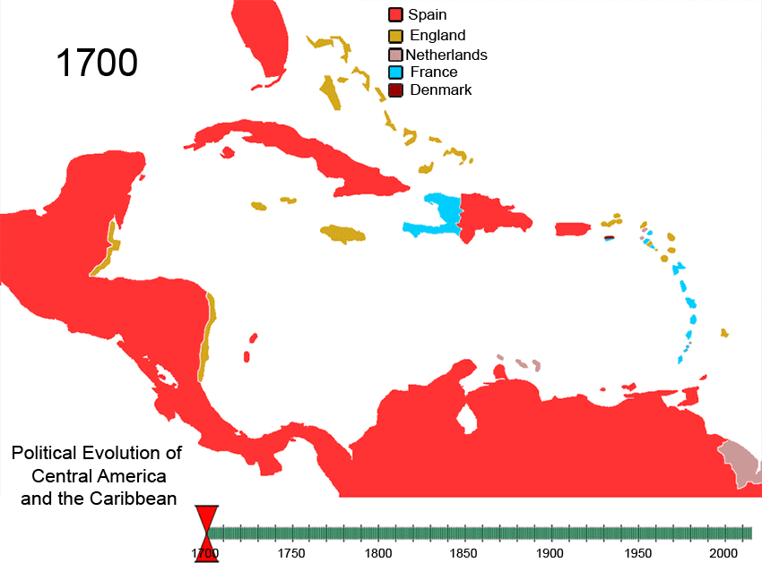
File:Political Evolution of Central America and the Caribbean 1700 and on.gif
پرش به ناوبری
پرش به جستجو
اندازهٔ این پیشنمایش: ۷۹۹ × ۶۰۰ پیکسل. کیفیتهای دیگر: ۳۲۰ × ۲۴۰ پیکسل | ۶۴۰ × ۴۸۰ پیکسل | ۸۵۰ × ۶۳۸ پیکسل.
پروندهٔ اصلی (۸۵۰ × ۶۳۸ پیکسل، اندازهٔ پرونده: ۳۴۸ کیلوبایت، نوع MIME پرونده: image/gif، چرخشدار، ۷۵ قاب، ۳ دقیقه ۳ ثانیه)
گزینهها
عنوان
شرحی یکخطی از محتوای این فایل اضافه کنید

|
این historical map نگاره میبایست با استفاده از گرافیک برداری اسویجی فایل بازسازی شوند. این چند مزیت دارد؛ Commons:Media for cleanup را برای اطلاعات بیشتر ببینید. اگر حالت برداری آن در حال حاضر موجود است، لطفاً آن را بار کنید. پس از بارکردن یک اسویجی، این الگو را با {{vector version available|new image name.svg}} جایگزین کنید.
|
| Caribbean | |||
|---|---|---|---|
| Antigua and Barbuda | |||
| Bahamas | |||
| Barbados | |||
| Belize | |||
| Cuba | |||
| Denmark | |||
| Dominica | |||
| Dominican Republic | |||
| Grenada | |||
| Haiti | |||
| Netherlands | |||
| Jamaica | |||
| Saint Kitts and Nevis | |||
| Saint Lucia | |||
| Saint Vincent and the Grenadines | |||
| Sweden | |||
| Trinidad and Tobago | |||
| United Kingdom | |||
| Spain | |||
| France | |||
| West Indies Federation | |||
| Central America | |||
| Costa Rica | |||
| El Salvador | |||
| Guatemala | |||
| Honduras | |||
| Nicaragua | |||
| Panama | |||
| Spain | |||
| Federal Republic of Central America | |||
| North America | |||
| Viceroyalty of New Spain | |||
| Yucatán (Republic of Yucatan) | |||
| Mexico | |||
| United States of America | |||
| South America | |||
| Viceroyalty of New Granada | |||
| Gran Colombia | |||
| Colombia | |||
| Venezuela | |||
| Guyana | |||
| *Flags used are flags of present day countries or the last flag used by a now-defunct nation. | |||
To recreate this animated gif you can use the following slides:


See Also
[ویرایش]-
 North America
 -
 Central America
 -
 Balkans
 -
 South America


Italic text
References
[ویرایش]
| توضیح | Political_Evolution_of_Central_America_and_the_Caribbean_1700_and_on | ||
| تاریخ | |||
| منبع | اثر شخصی | ||
| پدیدآور | Esemono | ||
| اجازهنامه (استفادهٔ مجدد از این پرونده) |
|
تاریخچهٔ پرونده
روی تاریخ/زمانها کلیک کنید تا نسخهٔ مربوط به آن هنگام را ببینید.
| تاریخ/زمان | بندانگشتی | ابعاد | کاربر | توضیح | |
|---|---|---|---|---|---|
| کنونی | ۲۷ فوریهٔ ۲۰۱۰، ساعت ۱۰:۳۰ | | ۸۵۰ در ۶۳۸ (۳۴۸ کیلوبایت) | Esemono (بحث | مشارکتها) | Fix dominica occuaption |
| ۵ مهٔ ۲۰۰۹، ساعت ۰۱:۵۵ |  | ۱٬۰۰۰ در ۷۵۰ (۴۱۴ کیلوبایت) | Esemono (بحث | مشارکتها) | Small date error | |
| ۵ مهٔ ۲۰۰۹، ساعت ۰۰:۰۲ |  | ۱٬۰۰۰ در ۷۵۰ (۴۲۲ کیلوبایت) | Esemono (بحث | مشارکتها) | CSA Belize Panama Zone correction USA Netherlands | |
| ۲۹ آوریل ۲۰۰۹، ساعت ۰۳:۲۳ |  | ۱٬۰۰۰ در ۷۵۰ (۳۹۶ کیلوبایت) | Esemono (بحث | مشارکتها) | eng to uk | |
| ۲ آوریل ۲۰۰۹، ساعت ۰۶:۰۸ |  | ۱٬۰۰۰ در ۷۵۰ (۳۹۷ کیلوبایت) | Esemono (بحث | مشارکتها) | Update add panama zone | |
| ۲ آوریل ۲۰۰۸، ساعت ۱۱:۲۲ |  | ۱٬۰۰۰ در ۷۵۰ (۳۹۲ کیلوبایت) | Esemono (بحث | مشارکتها) | {| align="right" border="0" style="border:1px solid #000000;" |+'''Nations past and present of the Caribbean''' |- ! colspan="4" | '''Caribbean''' |- | bgcolor="cc9933" width="30"| | width="10"| |Antigua and Barbuda |{{flagico |
نمیتوانید این پرونده را رونویسی کنید.
کاربرد پرونده
صفحههای زیر از این تصویر استفاده میکنند:
- Atlas of colonialism
- User:Esemono
- User:Mattes/Favorite files/Images/B
- File:Non-Native-American-Nations-Territorial-Claims-over-NAFTA-countries-1750-2008.gif
- File:Non-Native American Nations Control over N America 1750-2008.gif
- File:Non-Native American Nations Control over South America 1700 and on.gif
- File:Non-Native American Nations Control over South America 1700 and on.ogv
- File:Political Evolution of Central America and the Caribbean 1700 and on.gif
کاربرد سراسری پرونده
ویکیهای دیگر زیر از این پرونده استفاده میکنند:
- کاربرد در af.wikipedia.org
- کاربرد در ar.wikipedia.org
- کاربرد در ast.wikipedia.org
- کاربرد در ba.wikipedia.org
- کاربرد در bg.wikipedia.org
- کاربرد در bn.wikipedia.org
- کاربرد در ca.wikipedia.org
- کاربرد در cs.wikipedia.org
- کاربرد در cv.wikipedia.org
- کاربرد در de.wikipedia.org
- کاربرد در el.wikipedia.org
- کاربرد در en.wikipedia.org
- History of the Americas
- History of Jamaica
- History of the Caribbean
- History of Central America
- Portal:Caribbean
- List of conflicts in North America
- Portal:Jamaica
- List of land borders with dates of establishment
- Caribbean
- Territorial evolution of the Caribbean
- Talk:Latin America/Archive 3
- Invasion of Jamaica
- Colony of Jamaica
- List of conflicts in the Americas
- کاربرد در es.wikipedia.org
- کاربرد در eu.wikipedia.org
- کاربرد در fa.wikipedia.org
- کاربرد در fiu-vro.wikipedia.org
- کاربرد در fi.wikipedia.org
- کاربرد در fr.wikipedia.org
نمایش استفادههای سراسری از این پرونده.
ردهها:
- Animated maps of North America
- Animated maps of South America
- Territorial evolution of the Caribbean
- Maps of the history of Central America
- Maps of the history of North America
- Territorial evolution of South America
- Caribbean in the 18th century
- Caribbean in the 19th century
- Central America in the 18th century
- Central America in the 19th century
- North America in the 18th century
- North America in the 19th century
- South America in the 18th century
- South America in the 19th century
- Cuba in the 18th century
- Cuba in the 19th century
- Panama in the 18th century
- Venezuela in the 18th century
- Animated maps showing changing boundaries over time
- Maps of the Viceroyalty of New Spain
- Maps of the Viceroyalty of New Granada