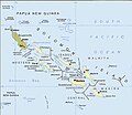
File:Political map of the Solomon Islands archipelago in 1989.jpg

Fitxer original (748 × 650 píxels, mida del fitxer: 72 Ko, tipus MIME: image/jpeg)
Llegendes
Llegendes

|
Aquesta imatge (de tipus mapa) s'hauria de tornar a crear utilitzant gràfics vectorials com ara un fitxer SVG. Això té diversos avantatges; en trobareu més informació a Commons:Media for cleanup. Si ja disposeu d'una versió d'aquesta imatge en format SVG, us preguem que la pengeu; després, reemplaceu aquesta plantilla amb la plantilla {{Vector version available|nom nou de la imatge.svg}} en aquesta imatge.
|
 | Aquesta imatge, o les imatges d'aquest article o categoria, ha estat carregada en format JPEG. Tanmateix, conté informació que es podria emmagatzemar més eficaçment o més acuradament en el format PNG o SVG. Si és possible, us preguem que carregueu una versió PNG o SVG d'aquesta imatge sense algoritmes de compressió, derivada d'una font no JPEG o sense codificació de compressió. |
Resum[modifica]
| DescripcióPolitical map of the Solomon Islands archipelago in 1989.jpg |
English: Solomon Islands map, modified and cropped from PCL map collection Courtesy of the University of Texas Libraries, The University of Texas at Austin.
According to the University of Texas, "most of the maps scanned by the University of Texas Libraries and served from this web site are in the public domain. No permissions are needed to copy them. You may download them and use them as you wish. A few maps are copyrighted, and are clearly marked as such.". As the image, when downloaded from here was no tagged, the map is PD. For a small map of the Solomon Islands, see: Image:SolomonIslandsMap.png Note that provincial borders are pre-1995; Rennell and Bellona has separated from Central Province, and Choiseul Province has separated from Western Province. Originally uploaded to En-Wikipedia by Darwinek on 13:39, 29 December 2004. |
| Data | |
| Font | Modified version of Solomon Islands (Political) 1989 from Perry-Castañeda Library Map Collection: Solomon Islands Maps. |
| Autor | U.S. Central Intelligence Agency |
| Permís (Com reutilitzar aquest fitxer) |
Public domain |
| Altres versions | File:Caste Solomon islands.jpg |
| This image is a copy or a derivative work of solomon_islands_pol89.jpg, from the map collection of the Perry–Castañeda Library (PCL) of the University of Texas at Austin.
This tag does not indicate the copyright status of the attached work. A normal copyright tag is still required. See Commons:Licensing for more information. |
Llicència[modifica]
| Public domainPublic domainfalsefalse |
| This image is a work of a Central Intelligence Agency employee, taken or made as part of that person's official duties. As a Work of the United States Government, this image or media is in the public domain in the United States.
čeština ∙ Deutsch ∙ eesti ∙ English ∙ español ∙ français ∙ italiano ∙ português ∙ polski ∙ sicilianu ∙ slovenščina ∙ suomi ∙ Tiếng Việt ∙ български ∙ македонски ∙ русский ∙ українська ∙ বাংলা ∙ മലയാളം ∙ 한국어 ∙ 日本語 ∙ 中文 ∙ 中文(简体) ∙ 中文(繁體) ∙ العربية ∙ پښتو ∙ +/− |

|
Historial del fitxer
Cliqueu una data/hora per veure el fitxer tal com era aleshores.
| Data/hora | Miniatura | Dimensions | Usuari/a | Comentari | |
|---|---|---|---|---|---|
| actual | 02:06, 12 abr 2016 |  | 748 × 650 (72 Ko) | Nimbosa (discussió | contribucions) | Reverted to version as of 02:02, 12 April 2016 (UTC) |
| 02:05, 12 abr 2016 |  | 748 × 650 (72 Ko) | Nimbosa (discussió | contribucions) | restored to original color as on print, corrected color map | |
| 02:02, 12 abr 2016 |  | 748 × 650 (72 Ko) | Nimbosa (discussió | contribucions) | restored to original color as on print, corrected color map | |
| 21:09, 1 març 2007 |  | 748 × 650 (72 Ko) | Pibwl (discussió | contribucions) |
No podeu sobreescriure aquest fitxer.
Ús del fitxer
Les 6 pàgines següents utilitzen aquest fitxer:
Ús global del fitxer
Utilització d'aquest fitxer en altres wikis:
- Utilització a als.wikipedia.org
- Utilització a ami.wikipedia.org
- Utilització a ast.wikipedia.org
- Utilització a bg.wikipedia.org
- Utilització a bn.wikipedia.org
- Utilització a ca.wikipedia.org
- Utilització a ceb.wikipedia.org
- Utilització a cs.wikipedia.org
- Utilització a da.wikipedia.org
- Utilització a el.wikipedia.org
- Utilització a en.wikipedia.org
- Utilització a en.wiktionary.org
- Utilització a es.wikipedia.org
- Utilització a fa.wikipedia.org
- Utilització a fi.wikipedia.org
- Utilització a fr.wikipedia.org
- Utilització a gl.wikipedia.org
- Utilització a hu.wikipedia.org
- Utilització a hy.wikipedia.org
- Utilització a hyw.wikipedia.org
- Utilització a id.wikipedia.org
- Utilització a it.wikipedia.org
- Utilització a ja.wikipedia.org
- Utilització a ka.wikipedia.org
- Utilització a kk.wikipedia.org
Vegeu més usos globals d'aquest fitxer.
Metadades
Aquest fitxer conté informació addicional, probablement afegida per la càmera digital o l'escàner utilitzat per a crear-lo o digitalitzar-lo. Si s'ha modificat posteriorment, alguns detalls poden no reflectir les dades reals del fitxer modificat.
| Autor | Picasa |
|---|---|
| Dia i hora de generació de les dades | 09:51, 12 abr 2016 |
| Resolució horitzontal | 72 ppp |
| Resolució vertical | 72 ppp |
| Programari utilitzat | GIMP 2.8.14 |
| Data i hora de modificació del fitxer | 10:01, 12 abr 2016 |
| Posició YCbCr | Centrat |
| Versió Exif | 2 |
| Significat de cada component |
|
| Versió Flashpix admesa | 1.01 |
| Espai de color | sRGB |
| Identificador únic de la imatge | 78d2cf04904f1c46b9582f5de975eac6 |
| Amplada de la imatge | 748 px |
| Alçària de la imatge | 650 px |
