File:Polska 1333 - 1370.png
跳至導覽
跳至搜尋

預覽大小:630 × 599 像素。 其他解析度:252 × 240 像素 | 505 × 480 像素 | 808 × 768 像素 | 1,077 × 1,024 像素 | 2,153 × 2,048 像素 | 2,636 × 2,507 像素。
原始檔案 (2,636 × 2,507 像素,檔案大小:1.28 MB,MIME 類型:image/png)
說明
說明
添加單行說明來描述出檔案所代表的內容
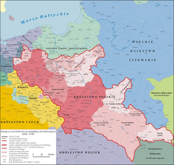
(En) Map of Poland and territorial borders during the reign of Casimir III the Great
| 描述 |
English: Map of Poland and territorial borders during the reign of Casimir III the Great (1333 - 1370) |
| 日期 | |
| 來源 | 自己的作品 na podstawie "Ilustrowany atlas historii Polski, wyd. Demart, Warszawa 2006" |
| 作者 | Poznaniak |
| 授權許可 (重用此檔案) |
我,本作品的著作權持有者,決定用以下授權條款發佈本作品: 此檔案採用創用CC 姓名標示-相同方式分享 3.0 未在地化版本授權條款。
|
| 其他版本 |
.png) |

|
本圖片是以PNG、GIF或JPEG格式上傳。然而,其中包含的資料或訊息,應該重新建立成可縮放向量圖形(SVG)檔案,以更有效率或更準確的方式儲存。如有可能,請上傳本圖片的SVG格式版本。在上傳之後,請修改維基各姊妹計畫中所有使用舊版圖片的條目(列在圖像連結章節中),替換為新版圖片,並在舊圖片的描述頁中加入{{Vector version available|新圖片名稱.svg}}模板,同時移除本模板。
|
檔案歷史
點選日期/時間以檢視該時間的檔案版本。
| 日期/時間 | 縮圖 | 尺寸 | 使用者 | 備註 | |
|---|---|---|---|---|---|
| 目前 | 2020年12月11日 (五) 08:16 | | 2,636 × 2,507(1.28 MB) | ElCet(留言 | 貢獻) | one of the bigger cities in Silesia back then |
| 2020年6月18日 (四) 17:16 |  | 2,636 × 2,507(1.39 MB) | Poznaniak(留言 | 貢獻) | Reverted to version as of 13:59, 7 October 2012 (UTC) nie po polsku, anachronizm | |
| 2020年6月12日 (五) 17:02 |  | 2,636 × 2,507(1.35 MB) | Claude Zygiel(留言 | 貢獻) | Ziemia Pokucie ([http://digi.ub.uni-heidelberg.de/diglit/skw1996/0457?sid=2c1eb70d8bde66653b23d0ee2a80832a] + [http://dir.icm.edu.pl/pl/Slownik_geograficzny/tom VIII/pp.550-555]) | |
| 2012年10月7日 (日) 13:59 |  | 2,636 × 2,507(1.39 MB) | Poznaniak(留言 | 貢獻) | popr. | |
| 2009年12月29日 (二) 20:58 |  | 2,636 × 2,507(1.42 MB) | Poznaniak(留言 | 貢獻) | popr. | |
| 2008年9月4日 (四) 11:15 |  | 2,637 × 2,507(1.44 MB) | Poznaniak(留言 | 貢獻) | {{Information |Description= |Source= |Date= |Author= |Permission= |other_versions= }} | |
| 2008年8月11日 (一) 18:59 |  | 2,636 × 2,507(1.39 MB) | Poznaniak(留言 | 貢獻) | ||
| 2008年8月3日 (日) 14:48 |  | 2,636 × 2,507(1.39 MB) | Poznaniak(留言 | 貢獻) | ||
| 2008年7月9日 (三) 13:05 |  | 2,636 × 2,507(1.47 MB) | Poznaniak(留言 | 貢獻) | {{Information |Description= |Source= |Date= |Author= |Permission= |other_versions= }} | |
| 2008年6月29日 (日) 16:29 |  | 2,636 × 2,507(1.45 MB) | Poznaniak(留言 | 貢獻) | {{Information |Description=Mapa Polski za panowania Kazimierza III Wielkiego (1333 - 1370) |Source=własna praca |Date=29.06.2008 |Author=Poznaniak |Permission={{self2|GFDL|cc-by-sa-2.5,2.0,1.0}} }} [[Category:Maps of the history of P |
無法覆蓋此檔案。
檔案用途
下列4個頁面有用到此檔案:
全域檔案使用狀況
以下其他 wiki 使用了這個檔案:
- af.wikipedia.org 的使用狀況
- ar.wikipedia.org 的使用狀況
- ba.wikipedia.org 的使用狀況
- be.wikipedia.org 的使用狀況
- br.wikipedia.org 的使用狀況
- ca.wikipedia.org 的使用狀況
- cs.wikipedia.org 的使用狀況
- da.wikipedia.org 的使用狀況
- de.wikipedia.org 的使用狀況
- el.wikipedia.org 的使用狀況
- en.wikipedia.org 的使用狀況
- Casimir III the Great
- Kingdom of Poland
- Galicia (Eastern Europe)
- Treaty of Kalisz (1343)
- Territorial evolution of Poland
- Lithuania–Poland relations
- Galicia–Volhynia Wars
- Treaty of Trentschin
- History of Poland during the Piast dynasty
- Lithuania–Poland border
- Polish irredentism
- User talk:2804:214:85D5:66E2:9433:EE28:15B8:C4F3
- Draft:Warsaw Trial 1339
- User:Falcaorib/Poland-Lithuania
- eo.wikipedia.org 的使用狀況
- es.wikipedia.org 的使用狀況
- et.wikipedia.org 的使用狀況
檢視此檔案的更多全域使用狀況。