File:Polska 1939-1941.png
Jump to navigation
Jump to search

Size of this preview: 441 × 599 pixels. Other resolutions: 176 × 240 pixels | 353 × 480 pixels | 565 × 768 pixels | 753 × 1,024 pixels | 2,482 × 3,373 pixels.
Original file (2,482 × 3,373 pixels, file size: 915 KB, MIME type: image/png)
Captions
Captions
Add a one-line explanation of what this file represents
Summary
[edit]| Description |
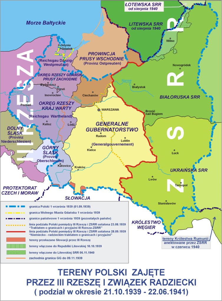
Polski: Tereny Polski zajęte przez III Rzeszę i ZSRR (21.10.1939 - 22.06.1941) (Polski)
English: Poland occupied by Nazi Germany (Third Reich) and the USSR (21/10/1939-22/06/1941) (Polish) |
| Date | |
| Source | Own work |
| Author | Lonio17 |
| Other versions |
[]
|

.png)


|
This historical map image could be re-created using vector graphics as an SVG file. This has several advantages; see Commons:Media for cleanup for more information. If an SVG form of this image is available, please upload it and afterwards replace this template with
{{vector version available|new image name}}.
It is recommended to name the SVG file “Polska 1939-1941.svg”—then the template Vector version available (or Vva) does not need the new image name parameter. |
Licensing
[edit]
I, the copyright holder of this work, hereby publish it under the following licenses:

|
Permission is granted to copy, distribute and/or modify this document under the terms of the GNU Free Documentation License, Version 1.2 or any later version published by the Free Software Foundation; with no Invariant Sections, no Front-Cover Texts, and no Back-Cover Texts. A copy of the license is included in the section entitled GNU Free Documentation License. |
This file is licensed under the Creative Commons Attribution-Share Alike 4.0 International, 3.0 Unported, 2.5 Generic, 2.0 Generic and 1.0 Generic license.
- You are free:
- to share – to copy, distribute and transmit the work
- to remix – to adapt the work
- Under the following conditions:
- attribution – You must give appropriate credit, provide a link to the license, and indicate if changes were made. You may do so in any reasonable manner, but not in any way that suggests the licensor endorses you or your use.
- share alike – If you remix, transform, or build upon the material, you must distribute your contributions under the same or compatible license as the original.
You may select the license of your choice.
File history
Click on a date/time to view the file as it appeared at that time.
| Date/Time | Thumbnail | Dimensions | User | Comment | |
|---|---|---|---|---|---|
| current | 21:19, 17 October 2021 | | 2,482 × 3,373 (915 KB) | Kamilhrub (talk | contribs) | +pierwotna granica GG |
| 17:49, 23 November 2015 |  | 2,482 × 3,373 (696 KB) | Poeticbent (talk | contribs) | marked the difference in hue between the old and new divisions following the invasion | |
| 07:00, 19 October 2009 |  | 2,482 × 3,373 (627 KB) | Lonio17 (talk | contribs) | {{Information |Description={{pl|1=Tereny Polski zajęte przez III Rzeszę i ZSRR (21.10.1939 - 22.06.1941)}} {{en|1=''translation:'' Polish lands occupied by the 3rd Reich and the USSR}} |Source={{own}} |Author=Lonio17 |Date=2009-10-19 |P | |
| 12:50, 30 May 2009 |  | 1,961 × 2,665 (1.82 MB) | Lonio17 (talk | contribs) | {{Information |Description={{pl|1=Tereny Polski zajęte przez III Rzeszę i ZSRR (21.10.1939 - 22.06.1941)}} |Source=Praca własna osoby przesyłającej (own work by uploader) |Author=Lonio17 |Date=2009-05-30 |Permission= |other_versions= | |
| 07:45, 30 April 2009 |  | 1,961 × 2,665 (1.82 MB) | Lonio17 (talk | contribs) | {{Information |Description=Tereny Polski zajęte przez III Rzeszę i ZSRR (21.10.1939 - 22.06.1941) |Source=Praca własna osoby przesyłającej (own work by uploader) |Date=2009-04-30 |Author=Lonio17 |Permission={{GFDL-self}} {{Cc-by-sa-3 | |
| 10:46, 29 April 2009 |  | 1,961 × 2,665 (1.82 MB) | Lonio17 (talk | contribs) | {{Information |Description=Tereny Polski zajęte przez III Rzeszę i ZSRR (21.10.1939 - 22.06.1941) |Source=Praca własna osoby przesyłającej (own work by uploader) |Date=2009-04-29 |Author=Lonio17 |Permission={{GFDL-self}} {{Cc-by-sa-3 | |
| 10:02, 24 April 2009 |  | 2,031 × 2,666 (1.82 MB) | Lonio17 (talk | contribs) | {{Information |Description=Tereny Polski zajęte przez III Rzeszę i ZSRR (21.10.1939 - 22.06.1942) |Source=Praca własna osoby przesyłającej (own work by uploader) |Date=2009-04-24 |Author=Lonio17 |Permission={{Cc-by-sa-3.0,2.5,2.0,1.0 | |
| 10:29, 21 April 2009 |  | 2,011 × 2,533 (1.75 MB) | Lonio17 (talk | contribs) | {{Information |Description=Tereny Polski zajęte przez III Rzeszę i ZSRR (21.10.39 - 22.06.1941) |Source=Praca własna osoby przesyłajacej (own work by uploader) |Date=2009-04-21 |Author=Lonio17 |Permission={{Cc-by-sa-3.0,2.5,2.0,1.0}} | |
| 10:40, 17 April 2009 |  | 2,099 × 2,404 (1.46 MB) | Lonio17 (talk | contribs) | {{Information |Description=Tereny Polski zajęte przez III Rzeszę i ZSRR (21.10.1939 - 21.06.1941) |Source=Praca własna osoby przesyłającej (own work by uploader) |Date=2009.04.17 |Author=Lonio17 |Permission={{Cc-by-sa-3.0,2.5,2.0,1.0 | |
| 09:47, 7 April 2009 |  | 1,833 × 2,764 (1.02 MB) | Lonio17 (talk | contribs) | {{Information |Description=Tereny Polski zajęte przez III Rzeszę i ZSRR (21.10.1939 - 22.06.1941) |Source=Praca własna osoby przesyłającej (own work by uploader) |Date=2009-04-07 |Author=Lonio17 |Permission={{Cc-by-sa-3.0,2.5,2.0,1.0 |
You cannot overwrite this file.
File usage on Commons
The following 10 pages use this file:
- User:Lonio17
- User:Magog the Ogre/Maps of conflicts/2015 November
- User:Magog the Ogre/Maps of conflicts/2021 October
- User:Stolbovsky/Recent uploads/Moscow/2015 November 21-30
- Commons:Graphic Lab/Map workshop/Archive/2014
- File:Occupation of Poland 1939-es.svg
- File:Occupation of Poland 1939.png
- File:Occupation of Poland 1939 (b&w).png
- File:Polska 1939-1941.png
- Template:Other versions/Occupation of Poland 1939
File usage on other wikis
The following other wikis use this file:
- Usage on ar.wikipedia.org
- Usage on ca.wikipedia.org
- Usage on de.wikipedia.org
- Usage on fr.wikipedia.org
- Usage on id.wikipedia.org
- Usage on krc.wikipedia.org
- Usage on lt.wikipedia.org
- Usage on ms.wikipedia.org
- Usage on pl.wikipedia.org
- II Rzeczpospolita
- Terytoria Polski anektowane przez III Rzeszę
- Kresy Wschodnie
- Podział administracyjny terenów II Rzeczypospolitej podczas II wojny światowej
- Wikipedysta:Lonio17
- Historia Polski (1939–1945)
- Dyskusja wikipedysty:Lonio17
- Wikipedysta:Rynio55/brudnopis/Garnizon Przasnysz/2
- Wikipedysta:Zmechowiec 75/brudnopis/Garnizon Przasnysz
- Usage on pt.wikipedia.org
- Usage on ro.wikipedia.org
- Usage on ru.wikipedia.org
- Usage on sq.wikipedia.org
- Usage on uk.wikipedia.org
- Usage on vi.wikipedia.org