File:Pont du Gard BLS.jpg
Siirry navigaatioon
Siirry hakuun

Tämän esikatselun koko: 800 × 309 kuvapistettä. Muut resoluutiot: 320 × 124 kuvapistettä | 640 × 247 kuvapistettä | 1 024 × 395 kuvapistettä | 1 280 × 494 kuvapistettä | 2 560 × 988 kuvapistettä | 12 648 × 4 882 kuvapistettä.
Alkuperäinen tiedosto (12 648 × 4 882 kuvapistettä, 18,75 MiB, MIME-tyyppi: image/jpeg)
Kuvatekstit
Kuvatekstit
Lisää yhden rivin pituinen kuvaus tästä tiedostosta
Der Pont du Gard in Südfrankreich
|
Yhteenveto[muokkaa]
| Kuvaus |
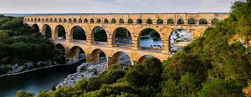
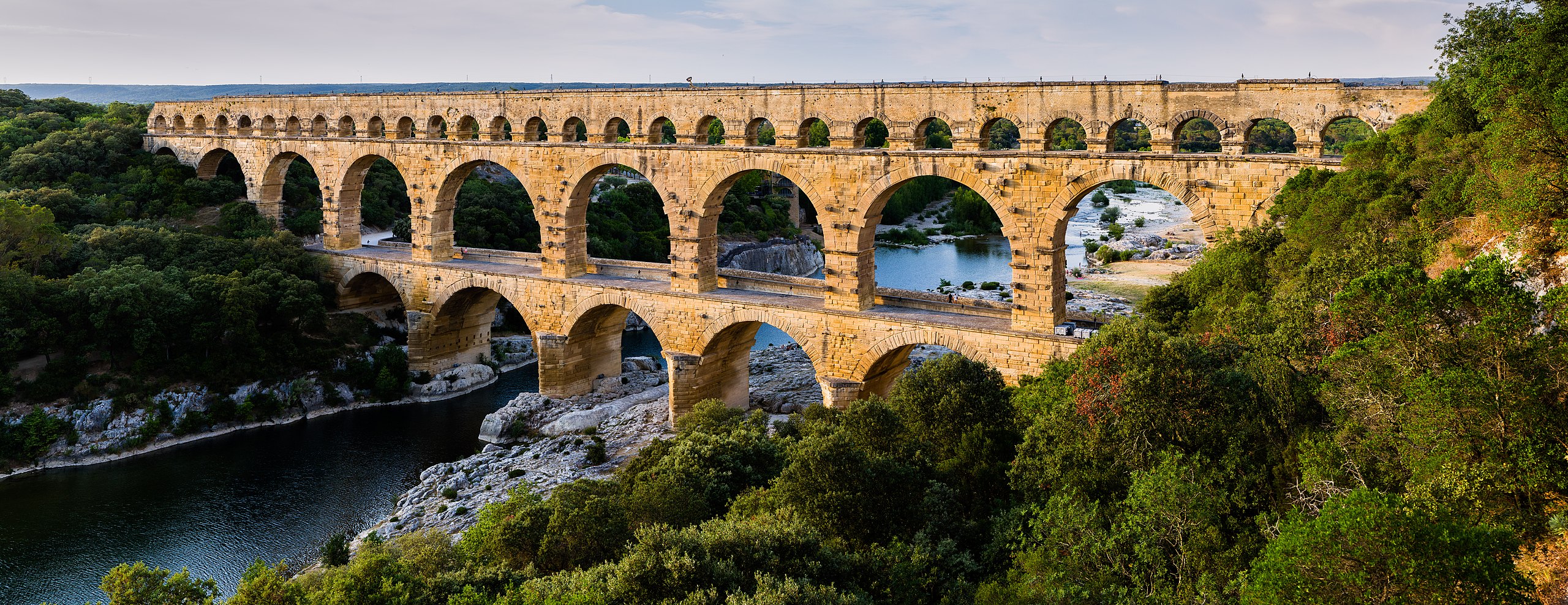
English: Pont du Gard, in Vers-Pont-du-Gard, Gard department, South France. The Pont du Gard is the most famous part of the roman aqueduct which carried water from Uzès to Nîmes until roughly the 9th century when maintenance was abandoned. The monument is 49m high and now 275m long (it was 360m when intact) at its top. It's the highest roman aqueduct, but also one of the best preserved (with the aqueduct of Segovia). The Pont du Gard has been a UNESCO world heritage site since 1985.
Français : Le Pont du Gard, à Vers-Pont-du-Gard, département du Gard, région Languedoc-Roussillon, France. Le Pont du Gard (1er siècle C.E.) est la partie la plus célèbre de l'aqueduc romain qui conduisait l'eau d'Uzès à Nîmes, jusqu'au 9ème siècle où l'on cessa de l'entretenir. Le monument fait 49 mètres de haut et aujourd'hui 275 mètres de long (360 mètres quand il était intact). C'est l'aqueduc roman le plus haut, mais aussi, avec celui de Ségovie, l'un des mieux préservés. Le Pont du Gard est un site du patrimoine mondial de l'humanité de l'UNESCO depuis 1985.
Español: El Pont du Gard (puente del Gard), en Vers-Pont-du-Gard, departamento de Gard, en la región de Languedoc-Rosellón, sur de Francia, es la parte más conocida del acueducto romano que conducía el agua desde Uzès a Nîmes hasta el siglo IX, cuando cesó su actividad. El puente mide 49 metros de alto y 275 metros de largo (360 m cuando se encontraba intacto en la antigüedad). Es el acueducto romano más alto y también, junto al de Segovia, en España, uno de los mejor conservados. El Pont du Gard fue declarado Patrimonio Mundial de la Humanidad por la UNESCO en 1985. |
| Päiväys | |
| Lähde | Pont du Gard |
| Tekijä | Benh LIEU SONG (Flickr) |
| Kameran sijainti | | Tämä ja muut kuvat kartalla: OpenStreetMap |
|---|
Lisenssi[muokkaa]
Minä, tämän teoksen tekijänoikeuksien haltija, julkaisen täten tämän teoksen seuraavalla lisenssillä:
Tämä tiedosto on lisensoitu Creative Commons Nimeä-JaaSamoin 3.0 Ei sovitettu -lisenssillä.
- Voit:
- jakaa – kopioida, levittää ja esittää teosta
- remiksata – valmistaa muutettuja teoksia
- Seuraavilla ehdoilla:
- nimeäminen – Sinun on mainittava lähde asianmukaisesti, tarjottava linkki lisenssiin sekä merkittävä, mikäli olet tehnyt muutoksia. Voit tehdä yllä olevan millä tahansa kohtuullisella tavalla, mutta et siten, että annat ymmärtää lisenssinantajan suosittelevan sinua tai teoksen käyttöäsi.
- jaa samoin – Jos muutat tai perustat tähän työhön, voit jakaa tuloksena syntyvää työtä vain tällä tai tämän kaltaisella lisenssillä.
| Annotations | This image is annotated: View the annotations at Commons |
Tiedoston historia
Päiväystä napsauttamalla näet, millainen tiedosto oli kyseisellä hetkellä.
| Päiväys | Pienoiskuva | Koko | Käyttäjä | Kommentti | |
|---|---|---|---|---|---|
| nykyinen | 19. kesäkuuta 2014 kello 17.57 | 12 648 × 4 882 (18,75 MiB) | Benh (keskustelu | muokkaukset) | Verticals. | |
| 19. kesäkuuta 2014 kello 10.55 | 12 648 × 4 771 (18,78 MiB) | Benh (keskustelu | muokkaukset) | User created page with UploadWizard |
Et voi tallentaa uutta tiedostoa tämän tilalle.
Tiedoston käyttö
Seuraavat 27 sivua käyttävät tätä tiedostoa:
- User:Benh
- User:Benh/sandbox
- User:Beria/POTY per date
- User:JPxG/Favorites
- User:JWilz12345/Cities-Europe
- User:Miya/POTY/2014
- User:Pechristener/Bridges/2014 June 11-20
- User:Zyephyrus/2015
- User:Ö/Best/2014
- User talk:Benh/Archive/2014
- Commons:Featured picture candidates/File:Pont du Gard BLS.jpg
- Commons:Featured picture candidates/Log/July 2014
- Commons:Featured pictures/Places/Architecture/Bridges
- Commons:Featured pictures/chronological/2014-B
- Commons:Picture of the Year/2014/Candidates
- Commons:Picture of the Year/2014/R1/Gallery/2014-B
- Commons:Picture of the Year/2014/R1/Gallery/ALL
- Commons:Picture of the Year/2014/R1/Gallery/Infrastructure
- Commons:Picture of the Year/2014/R1/Gallery/M07
- Commons:Picture of the Year/2014/R1/Results/Candidates
- Commons:Picture of the Year/2014/R1/Results/Candidates/Infrastructure
- Commons:Picture of the Year/2014/R1/Results/Infrastructure
- Commons:Picture of the Year/2014/R1/v/Pont du Gard BLS.jpg
- Commons:Quality images/Subject/Architecture/Transport Infrastructure/Bridges/Archive
- Commons:Quality images candidates/Archives July 02 2014
- Category:Pont du Gard
- Category:Views from Pont du Gard
Tiedoston järjestelmänlaajuinen käyttö
Seuraavat muut wikit käyttävät tätä tiedostoa:
- Käyttö kohteessa af.wikipedia.org
- Käyttö kohteessa ar.wikipedia.org
- Käyttö kohteessa ast.wikipedia.org
- Käyttö kohteessa ban.wikipedia.org
- Käyttö kohteessa bg.wikipedia.org
- Käyttö kohteessa bh.wikipedia.org
- Käyttö kohteessa bn.wikipedia.org
- Käyttö kohteessa bn.wikibooks.org
- Käyttö kohteessa bxr.wikipedia.org
- Käyttö kohteessa ca.wikipedia.org
- Käyttö kohteessa ceb.wikipedia.org
- Käyttö kohteessa cs.wikipedia.org
- Käyttö kohteessa cy.wikipedia.org
- Käyttö kohteessa da.wikipedia.org
- Käyttö kohteessa de.wikipedia.org
- Käyttö kohteessa de.wikivoyage.org
Näytä lisää tämän tiedoston järjestelmänlaajuista käyttöä.