File:Portable Atlas, or, the New Theater of War in Europe WDL39.png
Jump to navigation
Jump to search

Size of this preview: 800 × 561 pixels. Other resolutions: 320 × 225 pixels | 640 × 449 pixels | 1,024 × 719 pixels | 1,280 × 898 pixels | 1,459 × 1,024 pixels.
Original file (1,459 × 1,024 pixels, file size: 3.2 MB, MIME type: image/png)
Captions
Captions
Add a one-line explanation of what this file represents
Summary[edit]
| Author |
Русский: Ла Фей, Даниэль де
Français : La Feuille, Daniel de
English: La Feuille, Daniel de
中文:千叶, 丹尼尔
Português: La Feuille, Daniel de
العربية: لا فيل, دانيال دي
Español: La Feuille, Daniel de |
| Title |
Русский: Портативный атлас, или Новый театр военных действий в Европе
Français : Atlas portatif, ou le nouveau théâtre de la guerre en Europe
English: Portable Atlas, or, the New Theater of War in Europe
中文:便携式地图集,或,欧洲的新战场
Português: Atlas portátil ou o Novo Teatro de Guerra na Europa
العربية: الأطلس المحمول، أو، المسرح الجديد للحرب في أوروبا
Español: Atlas portátil, o el Nuevo teatro de la guerra en Europa |
| Description |
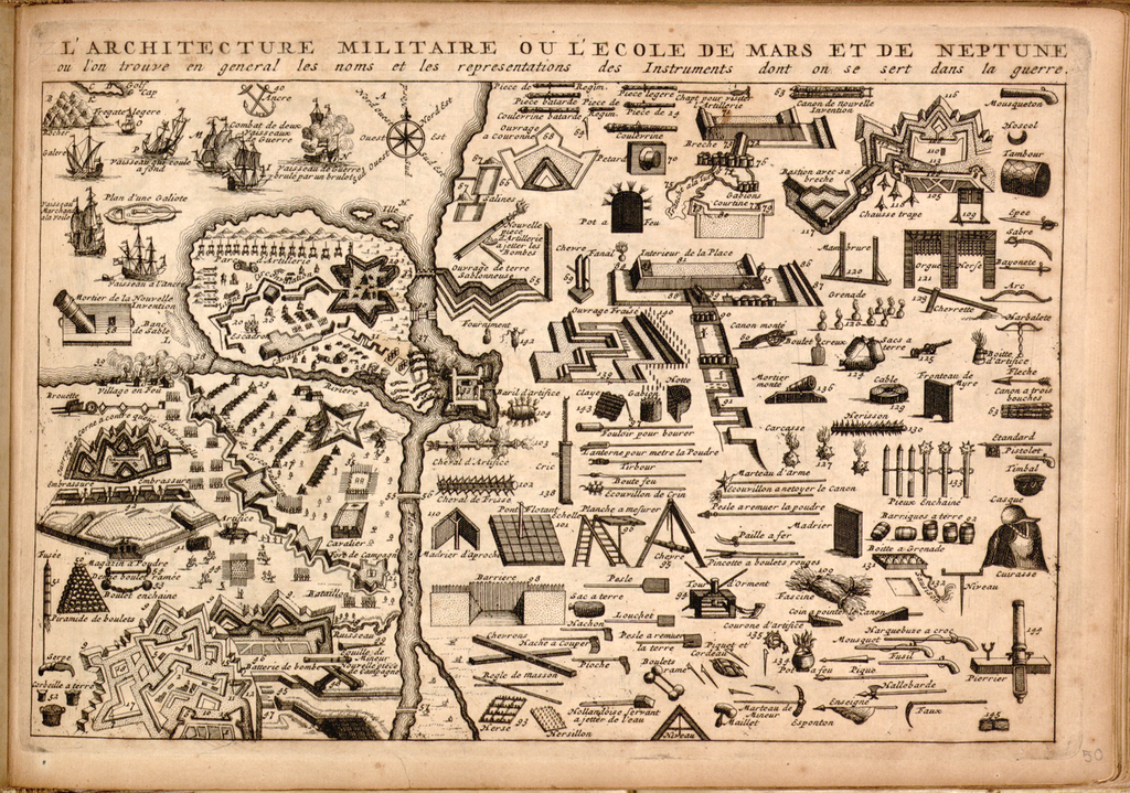
Русский: Даниэль де ла Фейиль был часовщиком, ювелиром, гравером и продавцом книг в Амстердаме в конце XVII – начале XVIII веков. Он также был составителем множества карт. В своем "переносном атласе" де ла Фейиль отразил все перепитии Войны за испанское наследство (1701-14 гг.), начавшейся после смерти короля Испании Карла II, который завещал королевство Филиппу, герцогу Анжуйскому, и внуку короля Франции из династии Бурбонов, Луи XIV. Обеспокоенные намерением французского Короля-Солнца утвердить свое доминирующее положение в Европе за счет могущественного франко-испанского государства под управлением дома Бурбонов, соперничающие между собой европейские государства объединились в военный союз под предводительством Англии и начали превентивную войну в целях недопущения установления гегемонии Франции. На данной карте представлен обзор военной архитектуры того времени, в том числе военных укреплений, фрегатов и парусных судов, оружия и военного имущества, которые использовались в новом театре военных действий в Европе.
Города и поселки; Война за испанское наследство, 1701-1714 гг. Français : Daniel de la Feuille était horloger, orfèvre, graveur et libraire à Amsterdam à la fin du XVIIe siècle et au début du XVIIe siècle. C'était aussi un cartographe prolifique. Dans cet « atlas portatif », il documente les complexités de la guerre de Succession d'Espagne (1701-1714), qui commença après la mort du roi d'Espagne, Charles II de Habsbourg, qui laissa son royaume à Philippe, duc d'Anjou et petit-fils du roi de France, Louis XIV de Bourbon. Inquiète que le Roi de France n'ait l'intention de dominer l'Europe en consolidant son pouvoir dans un État Bourbon franco-espagnol, une alliance concurrente de puissances européennes, dirigée par la Grande-Bretagne, déclencha une guerre préventive pour s’opposer à la perspective de l'hégémonie française. Cette carte présente une vue d'ensemble de l'architecture militaire de l'époque, dont des fortifications, des frégates et des navires à voiles, des armes et du matériel de guerre utilisés dans le nouveau théâtre européen des hostilités.
Petites et grandes villes; Succession d'Espagne, Guerre de, 1701-1714 English: Daniel de la Feuille was a watchmaker, goldsmith, engraver, and bookseller in Amsterdam in the late 17th and early 18th centuries. He was also a prolific mapmaker. In this “portable atlas,” de la Feuille documented the intricacies of the War of Spanish Succession (1701-14), which began after the Habsburg king of Spain, Charles II, died and left his kingdom to Philip, the Duke of Anjou and the grandson of the French Bourbon king, Louis XIV. Worried that France’s Sun King intended to dominate Europe by consolidating his power in a Bourbon Franco-Spanish state, a competing alliance of European powers, led by Great Britain, launched a preventive war to challenge the prospect of French hegemony. This map presents a survey of the military architecture of the day, including fortifications, frigates and sailing vessels, weaponry, and war matériel used in the new European theater of war.
Cities and towns; Spanish Succession, War of, 1701-1714 中文:Daniel de la Feuille 是 17 世纪末 18 世纪初阿姆斯特丹的一位钟表师、金匠、雕刻师和书商。 同时他还是一位多产的地图制图师。 在这份“便携式地图集”中,de la Feuille 记载了错综复杂的西班牙王位继承战争(1701-14 年),这场战争始于西班牙哈布斯堡国王查尔斯二世的去世,他把西班牙留给了法国波旁王朝国王路易十四的孙子安茹公爵菲利普。 因为担心法国的路易十四国王通过联盟波旁法国和西班牙国家以巩固自己的权利统治欧洲,所以欧洲各国在英国的领导下形成联盟,发动了一场先发制人、挑战法国霸权的战争。 这幅地图显示了制图人对当时军事架构的研究,包括防御工事、护卫舰和船舶、武器装备以及在新欧洲战场中使用的战争物资。
城镇; 西班牙王位继承战争,1701-1714 年 Português: Daniel de la Feuille foi um relojoeiro, ourives, gravador e livreiro em Amesterdã no final do século XVII e início do século XVIII. Foi, também, um prolífico cartógrafo. Neste "atlas portátil", de la Feuille documentou a complexidade da Guerra da Sucessão Espanhola (1701-1714), que se iniciou depois que o rei da Espanha (da Casa dos Habsburgos), Carlos II, morreu e deixou seu reino para Filipe, o Duque de Anjou e neto do rei Bourbon francês, Luís XIV. Preocupados com a intenção do Rei-Sol da França em dominar a Europa, consolidando o seu poder em um Estado Bourbon Franco-Espanhol, uma aliança de potências europeias concorrentes, liderada pela Grã-Bretanha, lançou uma guerra preventiva para desafiar a perspectiva de hegemonia francesa. Este mapa apresenta um levantamento da arquitetura militar do período, incluindo fortificações, fragatas e embarcações à vela, armamentos e material bélico utilizados no novo campo de batalha europeu.
Cidades e vilas; Sucessão Espanhola, Guerra da, 1701-1714 العربية: كان دانيال دي لا فاي ساعاتيا ونقاشا وصاحب مكتبة في أمستردام في أواخر القرن السابع عشر وبداية القرن الثامن عشر.
كما كان أيضا رساما للخرائط وفير الإنتاج. في هذا "الأطلس المتنقل"، وثّق دي لا فاي التعقيدات التي اتسمت بها حرب الخلافة الأسبانية (1701-14)، والتي بدأت بعد أن توفي ملك أسبانيا الهابسبورغي شارل الثاني، وترك مملكته إلى فيليب، دوق آنجو وحفيد الملك البوربوني الفرنسي لويس الرابع عشر.
ونتيجة للقلق من أن الملك الشمس في فرنسا عازم على بسط هيمنته على أوروبا من خلال توطيد سلطته في دولة اسبانية فرنسية بوربونية، شن تحالف منافس يتألف من قوى أوروبية منافسة للبوربون حربا وقائية للتحدي في وجه إمكانية الهيمنة الفرنسية.
تعرض هذه الخريطة نظرة شاملة للهندسة المعمارية العسكرية في ذلك الوقت، بما فيها من التحصينات والفرقاطات والسفن الشراعية، والأسلحة والمعدات الحربية الجديدة المستخدمة في المسرح الأوروبي الجديد للحرب.
المدن والبلدات; الوراثة الإسبانية، حرب 1701-1714 Español: Daniel de la Feuille fue relojero, orfebre, grabador y librero en Ámsterdam a finales del siglo XVII y principios del XVIII. También fue un prolífico cartógrafo. En este «atlas portátil», de la Feuille documentó las complejidades de la Guerra de Sucesión española (1701-1714), que comenzó después de que el rey Habsburgo de España, Carlos II, muriera dejando su reino a Felipe, duque de Anjou y nieto del rey Borbón francés, Luis XIV. Preocupado por la posibilidad de que el rey francés intentara dominar Europa consolidando su poder en un estado franco-español borbón, una alianza de poderes europeos liderada por Gran Bretaña, lanzó una guerra preventiva para enfrentarse a la perspectiva de una hegemonía francesa. Este mapa presenta un estudio de la arquitectura militar de la época, incluyendo fortificaciones, fragatas y veleros, armamento y material bélico utilizado en el nuevo teatro europeo de la guerra.
Ciudades y pueblos; Sucesión española, Guerra de, 1701-1714 |
| Date | 1708 |
| Medium |
Русский: Карты
Français : Cartes
English: Maps
中文:地图
Português: Mapas
العربية: خرائط
Español: Mapas |
| Dimensions |
English: 1 engraved map ; 17 x 26 centimeters |
| Collection |
Русский: Библиотека Конгресса
Français : Bibliothèque du Congrès
English: Library of Congress
中文:国会图书馆
Português: Biblioteca do Congresso
العربية: مكتبة الكونغرس
Español: Biblioteca del Congreso |
| Place of creation |
Русский: Европа
Français : Europe
English: Europe
中文:欧洲
Português: Europa
العربية: أوروبا
Español: Europa |
| Notes | Original language title: Atlas portatif, ou, le nouveau théâtre de la guerre en Europe |
| References | http://hdl.loc.gov/loc.wdl/dlc.39 |
| Source/Photographer |
|
Licensing[edit]
|
This is a faithful photographic reproduction of a two-dimensional, public domain work of art. The work of art itself is in the public domain for the following reason:
The official position taken by the Wikimedia Foundation is that "faithful reproductions of two-dimensional public domain works of art are public domain".
This photographic reproduction is therefore also considered to be in the public domain in the United States. In other jurisdictions, re-use of this content may be restricted; see Reuse of PD-Art photographs for details. | ||||
File history
Click on a date/time to view the file as it appeared at that time.
| Date/Time | Thumbnail | Dimensions | User | Comment | |
|---|---|---|---|---|---|
| current | 15:27, 11 March 2014 | | 1,459 × 1,024 (3.2 MB) | Fæ (talk | contribs) | =={{int:filedesc}}== {{Artwork |artist = |author ={{ru|1=Ла Фей, Даниэль де}} {{fr|1=La Feuille, Daniel de}} {{en|1=La Feuille, Daniel de}} {{zh|1=千叶, 丹尼尔}} {{pt|1=La Feuille, Daniel de}} {{ar|1=لا فيل, دانيال دي}}... |
You cannot overwrite this file.
File usage on Commons
The following page uses this file: