File:Portuguese Simbor 1911.png
Jump to navigation
Jump to search

Size of this preview: 516 × 600 pixels. Other resolutions: 206 × 240 pixels | 413 × 480 pixels | 661 × 768 pixels | 1,222 × 1,420 pixels.
Original file (1,222 × 1,420 pixels, file size: 2.37 MB, MIME type: image/png)
Captions
Captions
Add a one-line explanation of what this file represents
Summary[edit]
| Description |
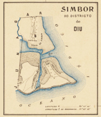
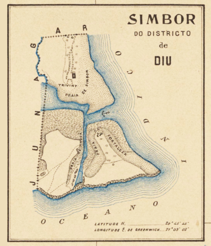
English: Basic map of the territory of Simbor, an exclave of the District of Diu located 25 km east of the city of Diu. This 1 sq. km territory comprised an island on which was built Fort St. Anthony of Simbor and, on the mainland bordering the Princely State of Junagadh (British India), two small strips of land on each side of the mouth of a small river. One end of the channel separating the island from the mainland appears to be blocked. That map is an insert of a Portuguese map of the District of Diu (Portuguese India) titled Carta topographico-agricola do districto de Diu. Published in 1911 by the Cartography Commission (Commissăo de cartographia). |
|||||||||
| Date | ||||||||||
| Source | Portuguese old colonial maps site | |||||||||
| Creator |
Comissão de cartographia |
|||||||||
| Geotemporal data | ||||||||||
| Bounding box |
|
|||||||||
| Georeferencing | ||||||||||
Licensing[edit]
|
This work is in the public domain in its country of origin and other countries and areas where the copyright term is the author's life plus 100 years or fewer. | |
| This file has been identified as being free of known restrictions under copyright law, including all related and neighboring rights. | |
File history
Click on a date/time to view the file as it appeared at that time.
| Date/Time | Thumbnail | Dimensions | User | Comment | |
|---|---|---|---|---|---|
| current | 19:52, 4 July 2019 | | 1,222 × 1,420 (2.37 MB) | Lubiesque (talk | contribs) | User created page with UploadWizard |
You cannot overwrite this file.
File usage on Commons
There are no pages that use this file.
File usage on other wikis
The following other wikis use this file:
- Usage on de.wikipedia.org
- Usage on en.wikipedia.org
- Usage on uk.wikipedia.org