File:Post-medieval lead dice shaker (FindID 518911).jpg
Jump to navigation
Jump to search

Size of this preview: 431 × 599 pixels. Other resolutions: 172 × 240 pixels | 345 × 480 pixels | 552 × 768 pixels | 736 × 1,024 pixels | 1,473 × 2,048 pixels | 3,975 × 5,527 pixels.
Original file (3,975 × 5,527 pixels, file size: 1.15 MB, MIME type: image/jpeg)
Captions
Captions
Add a one-line explanation of what this file represents
Summary
[edit]| Post-medieval lead dice shaker | |||
|---|---|---|---|
| Photographer |
Lincolnshire County Council, Adam Daubney, 2012-09-03 10:57:36 |
||
| Title |
Post-medieval lead dice shaker |
||
| Description |
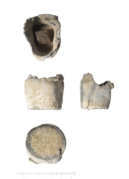
English: A post-medieval lead dice shaker and lead dice. The lead dice was found inside the shaker. The shaker is cylindrical, crudely made and damaged at the top. The top edge is torn and irregular. The base is smooth. The shaker has the size and appearance of other lead containers often recorded as bird feeders or powder-flask caps.
The dice is a rectangular cube measuring 13mm x 11mm and would therefore present a bias in the roll. The wider faces are numbered 1, 3, 5 and six, while the two narrower ends are numbered 2 and 4. The numbers are designed in negative relief with single circular holes. This object is difficult to date, but might be circa 1600-1800 (See: Egan, G. 'Dice', Finds Research Group 700-1700 Datasheet 23). |
||
| Depicted place | (County of findspot) Lincolnshire | ||
| Date | between 1600 and 1800 | ||
| Accession number |
FindID: 518911 Old ref: LIN-47EE46 Filename: LIN2012-737.jpg |
||
| Credit line |
|
||
| Source |
https://finds.org.uk/database/ajax/download/id/394951 Catalog: https://finds.org.uk/database/images/image/id/394951 Artefact: https://finds.org.uk/database/artefacts/record/id/518911 |
||
| Permission (Reusing this file) |
Attribution-ShareAlike License | ||
| Other versions |
|
||
.jpg)
.jpg&action=edit§ion=1)
| Object location | | View this and other nearby images on: OpenStreetMap |
|---|
.jpg¶ms=053.158600_N_0000.260044_E_globe:Earth_class:object_type:object__&language=en)
Licensing
[edit].jpg&action=edit§ion=2)
This file is licensed under the Creative Commons Attribution-Share Alike 2.0 Generic license.
Attribution: The Portable Antiquities Scheme/ The Trustees of the British Museum
- You are free:
- to share – to copy, distribute and transmit the work
- to remix – to adapt the work
- Under the following conditions:
- attribution – You must give appropriate credit, provide a link to the license, and indicate if changes were made. You may do so in any reasonable manner, but not in any way that suggests the licensor endorses you or your use.
- share alike – If you remix, transform, or build upon the material, you must distribute your contributions under the same or compatible license as the original.
File history
Click on a date/time to view the file as it appeared at that time.
| Date/Time | Thumbnail | Dimensions | User | Comment | |
|---|---|---|---|---|---|
| current | 12:09, 30 January 2017 | | 3,975 × 5,527 (1.15 MB) | Fæ (talk | contribs) | Portable Antiquities Scheme, LIN, FindID: 518911, post medieval, page 2321, batch count 8490 |
You cannot overwrite this file.
File usage on Commons
The following 2 pages use this file:
.jpg)
.jpg&oldid=544894251)