File:Post-rain Greening in Queensland (MODIS 2022-06-12).jpg

Original file (4,384 × 3,334 pixels, file size: 7.48 MB, MIME type: image/jpeg)
Captions
Captions
Summary
[edit].jpg&action=edit§ion=1)
| Description |
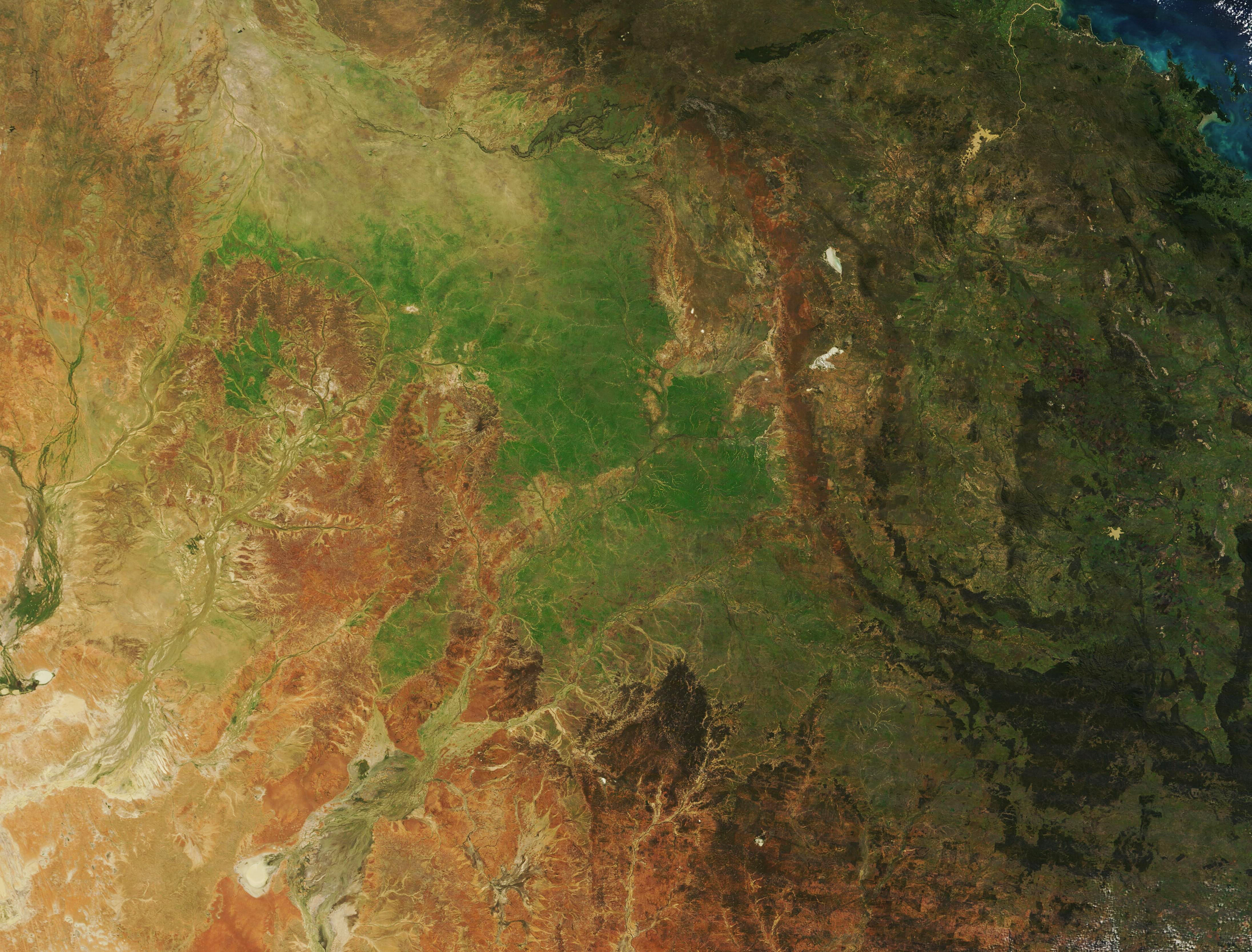
English: Much of Queensland, Australia, took a drenching in May 2022, with many locations reporting record-setting daily or monthly rainfall totals. According to the Australian Bureau of Meteorology (BOM), exceptional rainfall over large parts of Queensland during May resulted in the state experiencing its wettest May since 1989. With the month’s rainfall measuring 148.5 percent above average for Queensland overall, May 2022 also comes in at the fifth-wettest May ever recorded. In addition, temperatures were warm, especially at night, with parts of southeastern Queensland experiencing the warmest May nights on record since 1910.
While rain fell most of the month, heaviest rainfall was clustered near mid-month, especially between May 11 and 14. For example, on May 9, a severe weather update on local media forecast that the town of Longreach, in the hot, dry Outback, could receive 100 mm (3.9 inches) by the end of May 10. They also reported that the average rainfall for the entire month of May in Longreach was only 23 mm (0.9 inches). The region near that town has been suffering from drought, so the repetitive rains in May, despite short-lived flooding, were welcome in the Outback. Cattlemen have also been pleased that the May rains have brought a widespread flush of new, green grass across much of the state, allowing their herds to find food more easily. On June 10, 2022, the Moderate Resolution Imaging Spectroradiometer (MODIS) on board NASA’s Terra satellite acquired a true-color image of a verdant Australian outback following a wet April and wetter May. The image centers on the Central West region of Queensland. The town of Longreach sits roughly halfway between two of the salt flats seen in this image: the round Lake Yamma Yamma seen near the southwest (lower left) corner and the small, bright white oval of Lake Buchanan near the northeast corner (upper right). |
||
| Date | Taken on 10 June 2022 | ||
| Source |
Post-rain Greening in Queensland (direct link)
|
||
| Author | MODIS Land Rapid Response Team, NASA GSFC |
| This media is a product of the Terra mission Credit and attribution belongs to the mission team, if not already specified in the "author" row |
Licensing
[edit].jpg&action=edit§ion=2)
| This file is in the public domain in the United States because it was solely created by NASA. NASA copyright policy states that "NASA material is not protected by copyright unless noted". (See Template:PD-USGov, NASA copyright policy page or JPL Image Use Policy.) | ||
 |
Warnings:
|
File history
Click on a date/time to view the file as it appeared at that time.
| Date/Time | Thumbnail | Dimensions | User | Comment | |
|---|---|---|---|---|---|
| current | 22:01, 9 January 2024 | | 4,384 × 3,334 (7.48 MB) | OptimusPrimeBot (talk | contribs) | #Spacemedia - Upload of http://modis.gsfc.nasa.gov/gallery/images/image06122022_250m.jpg via Commons:Spacemedia |
You cannot overwrite this file.
File usage on Commons
There are no pages that use this file.
.jpg&oldid=909384539)